Nainital
| Nainital नैनीताल | |
|---|---|
| Hill station | |
|
View of Nainital Lake City | |
 Nainital | |
| Coordinates: 29°14′N 79°16′E / 29.23°N 79.27°ECoordinates: 29°14′N 79°16′E / 29.23°N 79.27°E | |
| Country | India |
| State | Uttarakhand |
| District | Nainital |
| Elevation | 2,084 m (6,837 ft) |
| Population (2011) | |
| • Total | 87,000 |
| Languages | |
| • Official | Hindi |
| • Other | Garhwali, Kumauni |
| Time zone | IST (UTC+5:30) |
| PIN | 263001/263002 |
| Telephone code | +91 - 5942 |
| Vehicle registration | UK 04 |
| Website |
nainital |

Nainital ![]() pronunciation is a popular hill station in the Indian state of Uttarakhand and headquarters of Nainital district in the Kumaon foothills of the outer Himalayas. Situated at an altitude of 2,084 metres (6,837 ft) above sea level, Nainital is set in a valley containing a pear-shaped lake, approximately two miles in circumference, and surrounded by mountains, of which the highest are Naina (2,615 m (8,579 ft)) on the north, Deopatha (2,438 m (7,999 ft)) on the west, and Ayarpatha (2,278 m (7,474 ft)) on the south. From the tops of the higher peaks, "magnificent views can be obtained of the vast plain to the south, or of the mass of tangled ridges lying north, bounded by the great snowy range which forms the central axis of the Himalayas.".[1]
pronunciation is a popular hill station in the Indian state of Uttarakhand and headquarters of Nainital district in the Kumaon foothills of the outer Himalayas. Situated at an altitude of 2,084 metres (6,837 ft) above sea level, Nainital is set in a valley containing a pear-shaped lake, approximately two miles in circumference, and surrounded by mountains, of which the highest are Naina (2,615 m (8,579 ft)) on the north, Deopatha (2,438 m (7,999 ft)) on the west, and Ayarpatha (2,278 m (7,474 ft)) on the south. From the tops of the higher peaks, "magnificent views can be obtained of the vast plain to the south, or of the mass of tangled ridges lying north, bounded by the great snowy range which forms the central axis of the Himalayas.".[1]
Geography and climate


Nainital is located at 29°23′N 79°27′E / 29.38°N 79.45°E.[2] The slopes of the nearby mountains are most populated, with an elevation ranging from 1,940–2,100 m (6,360–6,890 ft). The highest point nearby is Naina Peak or China Peak, with an elevation of 2,619 m (8,593 ft).
Nainital has temperate summers, maximum temperature 27 °C (81 °F); minimum temperature 7 °C (45 °F), during which its population increases more than fivefold with an annual influx of tourists predominantly from the plains of northern India. In winter, Nainital receives snowfall between December and February with the temperatures varying between a maximum of 15 °C (59 °F) and a minimum of −3 °C (27 °F).
Its climate is classified as subtropical highland (Cwb) according to Köppen-Geiger system.
| Climate data for Nainital | |||||||||||||
|---|---|---|---|---|---|---|---|---|---|---|---|---|---|
| Month | Jan | Feb | Mar | Apr | May | Jun | Jul | Aug | Sep | Oct | Nov | Dec | Year |
| Average high °C (°F) | 9.4 (48.9) |
11.2 (52.2) |
15.5 (59.9) |
19.9 (67.8) |
23.2 (73.8) |
22.9 (73.2) |
20.1 (68.2) |
19.6 (67.3) |
19.3 (66.7) |
18 (64) |
15.4 (59.7) |
12.4 (54.3) |
17.24 (63) |
| Daily mean °C (°F) | 5.2 (41.4) |
6.8 (44.2) |
10.6 (51.1) |
15 (59) |
18.2 (64.8) |
18.6 (65.5) |
17.2 (63) |
16.8 (62.2) |
15.9 (60.6) |
13.6 (56.5) |
10.6 (51.1) |
7.8 (46) |
13.03 (55.45) |
| Average low °C (°F) | 1.1 (34) |
2.4 (36.3) |
5.7 (42.3) |
10.1 (50.2) |
13.3 (55.9) |
14.4 (57.9) |
14.3 (57.7) |
14 (57) |
12.6 (54.7) |
9.3 (48.7) |
5.9 (42.6) |
3.2 (37.8) |
8.86 (47.92) |
| Average precipitation mm (inches) | 64 (2.52) |
56 (2.2) |
60 (2.36) |
35 (1.38) |
67 (2.64) |
178 (7.01) |
443 (17.44) |
381 (15) |
241 (9.49) |
76 (2.99) |
8 (0.31) |
27 (1.06) |
1,636 (64.4) |
| Source: Climate-Data.org[3] | |||||||||||||
Another uncited chart since June 2012.
| Climate data for Nainital | |||||||||||||
|---|---|---|---|---|---|---|---|---|---|---|---|---|---|
| Month | Jan | Feb | Mar | Apr | May | Jun | Jul | Aug | Sep | Oct | Nov | Dec | Year |
| Average high °C (°F) | 10.0 (50) |
13.0 (55.4) |
17.5 (63.5) |
21.0 (69.8) |
24.0 (75.2) |
24.0 (75.2) |
21.5 (70.7) |
21.5 (70.7) |
20.0 (68) |
16.0 (60.8) |
13.0 (55.4) |
11.5 (52.7) |
17.75 (63.95) |
| Average low °C (°F) | −4.5 (23.9) |
−2.0 (28.4) |
6.0 (42.8) |
11.5 (52.7) |
15.0 (59) |
17.5 (63.5) |
17.5 (63.5) |
16.0 (60.8) |
15.0 (59) |
10.0 (50) |
6.0 (42.8) |
1.5 (34.7) |
9.13 (48.43) |
| Average precipitation mm (inches) | 70 (2.76) |
80 (3.15) |
50 (1.97) |
30 (1.18) |
80 (3.15) |
380 (14.96) |
720 (28.35) |
700 (27.56) |
320 (12.6) |
50 (1.97) |
20 (0.79) |
30 (1.18) |
2,530 (99.62) |
| Average snowfall cm (inches) | 20 (8) |
8 (3) |
0.8 (.3) |
0 (0) |
0 (0) |
0 (0) |
0 (0) |
0 (0) |
0 (0) |
0 (0) |
2 (.8) |
23 (9) |
53.8 (21.1) |
Demographics
As of the 2001 Indian census,[4] Nainital had a population of 38,559. Males constitute 54% of the population and females 46%. Nainital has an average literacy rate of 91%, higher than the national average of 59.5%: male literacy is 98%, and female literacy is 96%. In Nainital, 1% of the population is under 6 years of age. Kumaonies form the major part of the town's population along with people from all over India.
Mythology
It is believed that Nainital figures in some ancient myths of India. In the Manas Khand of the Skand Puranas, Nainital Lake is called Tri-Rishi-Sarovar, hinting at the story of three sages (or rishis), Atri, Pulastya and Pulaha, who, upon finding no water in Nainital, dug a large hole at the location of the present day lake (sarovar = lake) and filled it with water from the holy lake Manasarovar in Tibet. According to lore, a dip in Naini Lake, "the lesser Manasarovar," earns merit equal to a dip in the great lake.
It is also believed that The Naini Lake is one of the 64 Shakti Peeths, or religious sites where parts of the charred body of Sati (Parvati) fell on earth while being carried by Lord Shiva. The spot where Sati's eyes (or Nain) fell, came to be called Nain-tal or lake of the eye. The goddess Shakti is worshipped at the Naina Devi Temple on the north shore of the present day lake.[5][6]
History

Early construction
The Kumaon Hills came under British rule after the Anglo-Nepalese War (1814–16), but the hill station town of Naini Tal was founded only in 1841, with the construction of the first European house (Pilgrim Lodge) by P. Barron, a sugar trader from Shahjahanpur. In his memoir, he wrote: "It is by far the best site I have witnessed in the course of a 1,500 miles (2,400 km) trek in the Himalayas."[7] In 1846, when a Captain Madden of the Bengal Artillery visited Naini Tal, he recorded that "houses were rapidly springing up in most parts of the settlement: some towards the crest of the limitary ranges were nearly 7,500 ft (2,300 m) above sea level: the rugged and woody Anyarpatta (Anyar-patt – in Kumaoni means – complete blackout. The reason for this nomenclature by the localites was because there were minimal sun rays due to its location and dense forests) was being gradually planted and that the favourite sites were on the undulating tract of forest land which stretched back from the head of the lake to the base of China and Deopatta (Camel's Hump). The church, St. John in the Wilderness, had been built, ..."[8] Soon, the town became a health resort favoured both by British soldiers and by colonial officials and their families trying to escape the heat of the plains. Later, the town also became the summer residence of the Governor of the United Provinces.
The landslip of 1880


In September 1880 a landslide (the landslip of 1880) occurred at the north end of the town, burying 151 people. The first known landslide had occurred in 1866, and in 1879 there was a larger one at the same spot, Alma Hill, but "the great slip occurred in the following year, on Saturday 18 September 1880."[8] "Two days preceding the slip there was heavy rain, ... 20 inches (510 mm) to 35 in (890 mm) fell during the 40 hours ending on Saturday morning, and the downpour still lasted and continued for hours after the slip. This heavy fall naturally brought down streams of water from the hill side, some endangering the Victoria Hotel, ... (which) was not the only building threatened ... Bell's shop, the Volunteer Orderly Room and the Hindu (Naina Devi) temple were scenes of labour with a view to diverting streams. At a quarter to two the landslip occurred burying those in and around the buildings mentioned above." The total number of dead and missing were 108 Indian and 43 British nationals. (See poem by Hannah Battersby on the page Literary references to Nainital). The Assembly Rooms and the Naina Devi Temple were both destroyed in the disaster. A recreation area known as 'The Flats' was later built on the site and a new temple was also erected. To prevent further disasters, storm water drains were constructed and building bylaws were made stricter.
Establishment of schools
.jpg)

In the latter half of the 19th century a number of "European" schools for boys and girls were founded in Nainital. During the Victorian and Edwardian eras, students in these schools consisted largely of children of British colonial officials or soldiers. The Diocesan Girls' High School, now known as All Saints' College, was established in 1869, near to where the High Court of Uttarakhand stands today. By 1906, there were over half a dozen such schools,[8] including the Diocesan Boys' School (later renamed Sherwood College) and the Philander Smith's college (later renamed halett war school, currently Birla Vidya Mandir). St. Joseph's College, Nainital, a day-boarding and residential school built by Irish brothers in 1888, celebrates its 125th anniversary in 2013. St. Joseph's College is popularly known as SEM. Another school established was St.Mary's Convent, popularly known as Ramnee, in 1878.
Transition

By the 1880s, a mere 42 years after its founding, Nainital had become something of an exclusive English preserve, with the Indian presence in the town confined largely to a behind-the-scenes labour and service industry, or to the occasional prince. This state of affairs lasted for much of the Victorian era. The first signs of change came early in the 20th century, when Indian bureaucrats and professionals began arriving in town as part of the annual migration of the state government of the United Provinces to Nainital every summer. By 1901 its population had risen to 7,609.[9]
The next big change came in 1925, when British civil servants began to receive subsidies for taking their annual vacations in England,[10] and, consequently, many stopped going to the hill stations in the summers. From then on until 1947 (excepting the war years), the British presence in Nainital (measured, for example, by home ownership) continued to decline and was gradually replaced by a burgeoning Indian presence.
Tourism

Tourism is the most significant segment of the Nainital's economy. Following are the places most visited by tourists :
Nainital Lake- Also known as Naini Lake, it is situated in the heart of the city and it is owing to this lake that Nainital earned its name. The eye-shaped lake is a tourist hotspot and acts as a magnet for all those visiting the hill resort. Here, a person can either take a leisurely stroll or indulge in boating and enjoy the surrounding beauty. The northern end of the lake is called Mallital, while the southern one is called Tallital. The Lake Bridge that connects the two banks has quite a few shops as well as a post office, the only one in the world to be located on a bridge.
Naina Devi Temple- The temple is located on the northern shore of Naini lake. The presiding deity of the temple is Maa Naina Devi represented by two Netras or eyes. Flanking Naina Devi are the deities of Mata Kali and Lord Ganesha. Nainital is believed to be one of the 64 Shaktipeeths, where one of the body parts of Goddess Sati fell, when Lord Shiva carried her body. In Nainital, the eyes (naina) of the Goddess are assumed to have fallen. The shrine of Naina Devi is a must visit for devout Hindus. and was reconstructed after being destroyed in the 1880 landslide. One can also get an amazing view of the hill station, overlooking the lake, from the temple.
St. John in the Wilderness, a church established in 1844 and is located on the north end of town (Mallital), about half a mile north-west of the Naina Devi temple. The church was so named by Daniel Wilson, the Bishop of Calcutta, who, after falling ill during a visit to Nainital in 1844 to lay the foundation of the church, was obliged to sleep in an unfinished house on the edge of the forest. (See excerpt from Josiah Bateman on the Literary references to Nainital page.) A brass plaque on the altar is inscribed with names of the victims of the Landslip of 1880.
Governor's House also known Raj Bhavan and formerly, Government House was built in 1899 and designed in the Victorian Gothic domestic style (also called "domestic Gothic") by the architect F.W. Stevens. Originally built as the summer residence of the governor of the North West Province, it later became the summer residence for the Lieutenant Governor of the United Provinces. Currently, Raj Bhavan is the official guest house for the governor of Uttarakhand and for visiting state guests. The complex consists of a two-storied mansion with 113 rooms, a large garden, a swimming pool, and golf links. Obtaining prior permission is a "must" for visiting.

Snow View is situated at an altitude of 2,270 m (7,450 ft) and located atop the Sher-ka-danda Ridge (north by north-east of the town centre), is easily reachable by cable car.Charges for cable car is Rs. 150 per person, Rs. 75 for child. Charges are for stay for one hour at the point. Timings are 10.00 am to 5.00 pm on a clear day, it offers spectacular views of the snowbound high Himalaya, including Nanda Devi, Trisul, and Nanda Kot. The best time of the year for viewing the mountains is late October and November. (See excerpts from Joseph Fayrer on the Literary references to Nainital page.)
Naini Peak also known as China or Cheena Peak or Naina Peak is the highest peak in the town, with an altitude of 2,615 m (8,579 ft). and at a walking distance of 6 km (3.7 mi) from the north end of the town (Mallital). From atop the peak, one can not only see a broad swath of the snow clad high Himalaya, but also obtain a panoramic view of Nainital town itself. The summit is an invigorating hike from Nainital town; in addition, for the less energetic visitors, ponies can be hired in Mallital or on Snow View and the Great Wall of China
Tiffin Top also known as Dorothy's Seat This terraced hill top (2,292 m (7,520 ft)) on Ayarpatta hill is a 4 km (2.5 mi) hike from the town centre and commands a nice view of the neighbouring country side. Dorothy's Seat is a stonework picnic perch on Tiffin Top built as a memorial to a British Army Officer's wife, Dorothy Kellet, by her husband Col J.P. Kellett DSO MC, City of London Regiment, and admirers after her death from septicaemia aboard a ship bound for England to be with her 4 children, Elizabeth, Joan, Barbara and Richard. She was buried at sea in The Red Sea in 1936.
The High Court of Uttarakhand building formerly known as the 'Old Secretariat', when Nainital was the summer capital of United Provinces.

Pt. G.B. Pant High Altitude Zoo: Opened in 1994, it is one of the two High altitude Zoo in India, Second is in Darjeeling, West Bengal. It houses various Phesants e.g. Kaleej Phesant etc.; high altitude endangered Mammals like Siberian Tiger, Snow Leopard, Goat Antelope-Ghooral and Serao etc. The animals are according to their habitat altitude, e.g. Snow Leopard is kept on the highest point.
Gurney House, the former residence, of Jim Corbett, is located on Ayarpatta Hill. Before leaving for Kenya, Jim and his sister Maggie sold the house to a zamindari family in Bihar. It is a private residence but is open to visitors as a museum of Corbett memorabilia.
Eco Cave Gardens is a natural garden which is situated just next to Kumaon University Campus. It is just 1 km away from Sukhatal and 2 km from Mallital. It has six caves along with a musical fountain.[11]
Others: Laria Kanta, Land's End and Sukhatal. The surrounding hillside is rich with deodar, oak, pine and rhododendron.
Places near Nainital

Bhimtal Lake – Situated 22 km from the city centre, Bhimtal Lake is the biggest lake of Nainital. It is named after the second Pandava brother Bhima in the Mahābhārata who was known for his prodigious strength. The lake, which is larger than Naini Lake, is approximately 22 km (14 mi) from Nainital at an altitude of 1,370 m (4,490 ft). There is an island in the lake with a popular restaurant on it. There is also a 17th-century temple complex, the Bhimeshwar, alongside a 40 ft (12 m) high dam at one end of the lake.
Sattal, literally Seven Lakes, is at a distance of about 23 km (14 mi) from Nainital in the Lower Himalayan Range at an altitude of 1,370 m (4,490 ft). It is a cluster of small interconnected lakes in the midst of an old oak forest. On approaching Sattal, the first lake encountered is the Nal-Damyanti Lake; next it is the Panna or Garude lake; and finally there is a cluster of three lakes: Ram, Laxman and Sita lakes.
Khurpa Tal, literally Trowel Lake, is an attractive lake about 10 km (6.2 mi) by road (or a 5 km (3.1 mi) hike) from Nainital at an altitude of 1,635 m (5,364 ft). It is popular with anglers and is surrounded by terraced fields (or farms), from which it presumably gets its name.

Naukuchia Tal, literally, Nine-Cornered Lake, is 26 km (16 mi) from Nainital and 4 km from Bhimtal at an altitude of 1,220 m (4,000 ft). The lake is almost 1 km (0.62 mi) long, 0.5 km (0.31 mi) wide and approximately 40 m (130 ft) deep. It is the deepest of the lakes in the greater Naintal area. According to legend, if one takes in all nine corners in one glimpse, one can disappear in a cloud of smoke. (See excerpts from J. W. M'Crindle on the Literary references to Nainital page.)
Hanumangarhi, also known as Hanuman Garh, is located at an altitude 1,951 m (6,401 ft). The temple complex is about 3.5 km (2.2 mi) from the Tallital (South End) bus stop. The presiding deity of the temple is Lord Hanuman, the vanara god of the Ramayana, and he is depicted tearing open his chest to reveal Rama and Sita in his heart. It is connected saint Neem Karoli Baba, who had his ashram at Kainchi. Hanuman Garhi is also known for its spectacular views.
Mahesh Khan FRH Mahesh Khan is near Bhowali. Bhowali is 40 km from Haldwani or 10 km from Nainital you can contact at forest range office at Bhowali for booking. It is situated in quite and dense forest and this FRH is recently renovated.
Ghorakhal- Ghorakhal is the place situated in the Nainital district of the Uttarakhand state of India. Ghorakhal means pond for water to horses. It is the picturesque site at the height of more than 2,000 metres. This place is famous for the prestigious sainik school ghorakhal which is considered one of the top boarding schools in India & temple of Lord Golu which is worshiped by the hill people.[12]
Educational and research institutions
The schools

For well over a century, Nainital has been known for its many schools. Four schools from the British period continue to exist today: Sherwood College,[13] established 1869; All Saints' College,[14] established 1869; St. Mary's Convent High School established 1878; St. Joseph's College established 1888. In addition, a number of new schools have been established since independence: Birla Vidya Mandir, established 1947; Sanwal Public School, established in the 1952 in Mallital; St. Amtul's Public School, established 1983; Parvati Prema Jagati Saraswati Vihar, established 1983; and Oakwood School, established 1989. Chait Ram Sah Thulgharya Inter College (CRST) Nainital Mallital; Government Inter College, Tallital; Government Girls Inter College, Tallital; Bhartiya Saheed Sainik Vidhlay (BSSV) Nainital, Sainik School, established 1966, in Gorhkhal, Bhowali; St. Xavier's School, established 1991, Upper Ayyarpatta,Nainital,.,[15] HGS, Bhimtal, Lakes International,Bhimtal and many more.
Kumaon University (also spelt Kumaun University)
Nainital is home to one of the two campuses of Kumaon University[16] (the other being Almora 'SSJ Campus'). The university was founded in 1973 when it incorporated the Dev Singh Bisht (DSB) Government College (commonly called "the Degree College"), which had been founded in 1951 by Dan Singh Bist in memory of his late father, Dev Singh Bist.
Noted environmentalist and member of Kumaon University Professor Ajay Singh Rawat who is responsible for preserving many heritage buildings and lakes in Nainital, has called setting the setting up by Dan Singh Bist of DSB college, as the pioneer step for higher education in Kumaon in his book "Nainital Beckons' and also in the journal 'Udaan' for Uttrakhand Open University where he was the Chief editor. Thus was set the stage for Nainital to emerge as a destination educational hub from a place where the post independence generation was the first to be educated. Kumaun University has been awarded FOUR Stars status by the National Assessment and Accreditation Council (NAAC).
ARIES (State Observatory)
The 50-year old State Observatory at Nainital was reborn in 2004 as ARIES, the Aryabhatta Research Institute of Observational Sciences, an autonomous institute under the Department of Science and Technology, Government of India. The observatory, which had come into existence in Varanasi in 1954, was moved the following year to Nainital, under its more transparent skies. In 1961 it was moved once again to its present location, Manora Peak (1,951 m (6,401 ft)) — a few km south of the Nainital town. ARIES's main objective is to provide national optical observing facilities for research in astronomy, astrophysics and the atmospheric sciences.
Libraries
There are a number of libraries in the Nainital area. Among them are the Durga Lal Shah Municipal Public Library, on the Mall, founded in 1934;[17] the Uttarakhand Academy of Administration, Library and Documentation Center, Mallital;[18] the ARIES Observatory Library;[19] and the Kumaon University Library, Nainital.[20]
Environmental degradation

In recent years, academics, geologists, concerned citizens and the judiciary have become alarmed at the rate of new construction in Nainital and its effect on the Naini Lake. As a result, efforts have been undertaken to check the deterioration of the lake and its surrounding ecosystem. De-silting of the lake and afforestation of the catchment area have been initiated; however, these measures have not been sufficient to cope with the ever increasing pressure on its fragile ecosystem. The number of tourists, and with them the number of vehicles entering the town, is rapidly increasing and this, if not checked, could turn Nainital into a disfigured and despoiled town.
For example, it has been noticed that hundreds of fish die in Naini Lake every winter, the last such event having occurred in January 2006. Naini Lake is 20 m (66 ft) deep, but, according to experts, the level of oxygen in the hypolimnic layer (the bottom, colder, stagnant and constant temperature layer) is much lower than is required to sustain fish—and this is mostly due to pollution, which includes illegal dumping of rubbish. The problem is exacerbated during winters when the polluted and nearly anoxic (i.e. lacking oxygen) water from the bottom moves up to the surface on account of the lower temperature of the surface water. Fish die due to low oxygen content in this altered surface water. According to Rakesh Kumar, once District Magistrate of Nainital, "The main problem is trying to syphon off the water from the hypolimnic layer, 6 m (20 ft) from the bottom of the lake. Once that is done, we can increase the oxygen content in the lake using aeration methods. That is the only permanent solution."
In recent times some enlightened citizens have come forward to halt the degradation of this beautiful town. Since 2007 every 18 September is now observed as 'Clean up Nainital Day', in rememembrance of devastating landslide of 18 September 1880, which consumed 151 lives. On this historic day students and other sections of society join hands to clean the town. Further, a women's group 'Maitri', does this cleaning work voluntarily now on every 18th. Taking cue from this, the Municipality and District administration have started the scheme of 'Mission Butterfly' for the solid waste management and have appointed 'Lake Wardens' from the civil society to keep an eye on the polluters.
In recent years with the help of government and local environmental groups the lake Aeration Project was started. The primary aim of the project was to decrease the BOD (biological oxygen demand) of the lake water. Anaerobic digestion of lake sediments is a much slower process than with aerobic digestion. Where aerobic digestion can result in the control or reduction of organic sediment levels, anaerobic digestion almost always allows organic sediments levels to increase. During anaerobic digestion, bacterial enzymes and lack of oxygen make the nutrients in the bottom sediments soluble. Then the nutrients return to the water column and are available to support new weed and algae growth. Anaerobic conditions at the lake bottom have a damaging effect on the food chain that supports fish populations as well as reducing or eliminating fish habitat, ultimately resulting in a reduction of the fish quality, size and quantity.
To resolve this problem and improve the quality of the lake water, many underground high pressure jets were laid near the lake bed at various places throughout the lake. The jets are supplied with highly pressurised air through a compressor located near the Golu Devta temple. This compressed air is released via a net of jets near the lake bed, the air bubbles through the water. In the process aeration the water and improving the quality of water. Today one can see the results of hard work and efforts of the past few years.
The lake water has become visibly cleaner and BOD levels have reduced dramatically. To complement the lake aeration project, with the help of scientist from the Govind Ballabh Pant University of Agriculture and Technology, Pantnagar. A number of plankton and algae eating fishes were introduced in the lake. This has resulted in speeding up the cleaning up process. Now unlike in the past no more dead fishes on the lake's surface. In fact now the large number of colourful healthy fishes are a beautiful sight to see for tourists and local alike.

Nainital in literature
Among the major authors who referred to Nainital in their writings were Rudyard Kipling, Munshi Premchand, Yashpal, Jainendra Kumar, Rahul Sankrityayan and Jim Corbett.
Media
Nainital has an All India Radio Relay station known as Akashvani Nainital. It broadcasts on FM frequencies.
Famous people with links to Nainital
- Elsie Inglis, physician and social reformer
- Jim Corbett, hunter of man-eating tigers, author, conservationist and namesake of Jim Corbett National Park
- Govind Ballabh Pant, statesman and leader of India's independence movement, first Indian Premier of British India, the first Chief Minister of Uttar Pradesh and the first Home Minister of India
- Hastings Ismay, 1st Baron Ismay, first secretary general of NATO
- Percy Hobart, British major general and military engineer
- Orde Charles Wingate, British general and commander of the Chindits in Burma during World War II
- Soham Swami, guru and yogi
- Niralamba Swami, guru and yogi
- Swami Sri Lilashahji Maharaj, guru and yogi, guru of Sant Sri Asaramji Bapu
- Swami Swarupananda, first president of Advaita Ashrama and direct disciple of Swami Vivekananda
- Sam Manekshaw, Indian Army Chief of Staff during Indo-Pakistani War of 1971
- Som Nath Sharma, India's first Param Vir Chakra award winner
- Narayan Dutt Tiwari, Indian leader and politician, former Governor of Andhra Pradesh, former Chief Minister of Uttarakhand and Uttar Pradesh, and former Finance Minister of India.
- Krishna Chandra Pant, former Deputy Chairman of the Planning Commission of India
- Rajendra K. Pachauri, chairman of the Intergovernmental Panel on Climate Change
- Vandana Shiva, philosopher, environmental activist and eco feminist
- Sudhir Kakar, renowned psychoanalyst
- Anup Jalota, singer
- Amitabh Bachchan, Bollywood actor
- Naseeruddin Shah, Bollywood actor
- Kabir Bedi, Bollywood Actor
- Ruskin Bond, writer and novelist
- Danny Denzongpa, Bollywood actor
- Nirmal Pandey, Bollywood actor and singer
- Dilip Tahil, Bollywood actor
- Manish Pandey, cricketer who plays for Karnataka and Bangalore
- Eric Maturin, British actor
- Lalit Modi, Indian Premier League (IPL) chairman
- Manasvi Mamgai, Miss India World 2010
- Shivani, Famous Hindi poet
Gallery
-
.jpg)
Naini Lake after snowfall (2007)
-

Nainital in May 2011
-

Boats on the Lake.
-

The Mall Road, 2006.
-

Ramlila Bhawan, Mallital, Nainital.
-

A view from Hotel Naini Retreat's Balcony.
-

Nainital Lake in 2009.
-

Statue of Govind Ballabh Pant, at Mall Road, Nainital.
-
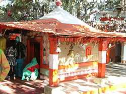
Golu Devta temple, at Ghorakhal near Nainital.
-

Naini Lake
-

Yachts in Naini Lake in March 2011
-

Urban areas
-

Gurney House-the home of Jim Corbett
Notes and references
- ↑ Nainital District The Imperial Gazetteer of India, volume 18, pp. 322–323. 1908
- ↑ Falling Rain Genomics, Inc – Nainital. Fallingrain.com.
- ↑ "Climate: Nainital – Climate graph, Temperature graph, Climate table". Climate-Data.org. Retrieved 27 August 2013.
- ↑ Census of India. Censusindia.gov.in (14 May 2012).
- ↑ File:View of Mallital, without the present Naina Devi Temple, Nainital, 1865.jpg British Library.
- ↑ File:View of Nainital, from the South East (Tallital side), 1865.jpg British Library.
- ↑ (Pilgrim 1844)
- ↑ 8.0 8.1 8.2 (Murphy 1906)
- ↑ Naini Tal
 This article incorporates text from a publication now in the public domain: Chisholm, Hugh, ed. (1911). Encyclopædia Britannica (11th ed.). Cambridge University Press..
 - ↑ (Kennedy 1996)
- ↑ Cave Gardens. eNainital.com.
- ↑ NAINITAL TOURISM 1000 + Pages Since 1999 – Ghorakhal | Ghorakhal Temple | Golu Devta – The God of Justice |. Nainitaltourism.com.
- ↑ Old Sherwoodians. Old Sherwoodians.
- ↑ All Saint's College, Nainital. Allsaintscollege.org.
- ↑ St. Xavier's School, Nainital. Stxavierntl.com.
- ↑ Kumaun University
- ↑ Singh, Sarina (2005). Lonely Planet: India (Nainital). ISBN 1-74059-694-3. Page 425.
- ↑ The World Bank India: Depository Libraries, 2006.
- ↑ Astronomical Networking Libraries
- ↑ Kumaon University
- Bateman, Josiah (1860), The Life of The Right Rev. Daniel Wilson, D.D., Late Lord Bishop of Calcutta and Metropolitan of India, Volume II, John Murray, Albemarle Street, London.
- Corbett, SAYUJ (2000 (2002)), Inter H.G.S – Indian Culture in Daily Life., Oxford India Reprint Check date values in:
|date=(help) - Corbett, Jim (1948 (2002)), The Man Eating Leopard of Rudraprayag, Oxford India Reprint Check date values in:
|date=(help) - Corbett, Jim (1954 (2002)), The Temple Tigers and More Man-Eaters of Kumaon, Oxford India Reprint Check date values in:
|date=(help) - Fayrer, Joseph (1900), Recollections of my life, William Blackwood and Sons, Edinburgh and London
- Imperial Gazeteer of India (1908), Imperial Gazeteer of India, Volume 18, pp. 322–323., Oxford University Press, Oxford and London
- Kennedy, Dane (1996), The Magic Mountains: Hill Stations and the British Raj, University of California Press, Berkeley, Los Angeles, and Oxford. 264 pages.
- Kipling, Rudyard (1889), The Story of the Gadsbys, Macmillan and Company, London
- Kipling, Rudyard (1895), Under the Deodars, Macmillan and Company, London
- McLaren, Eva Shaw (1920), Elsie Inglis: The Woman with the Torch, Macmillan and Company, New York
- M'Crindle, J.W. (1901), Ancient India: As Described in Classical Literature, Archibald ConstaHble & Company, Westminster
- Murphy, C.W. (1906), Notes on Wanderings in the Himmala, containing descriptions of some of the grandest scenery of the snowy range, among others of Naini Tal, Agra Akhbaar Press, Agra
External links
| Wikimedia Commons has media related to Nainital. |
| Wikisource has the text of the 1911 Encyclopædia Britannica article Naini Tal. |
- Nainital Information and Pictures
- Official website
- Official web-site of Uttarakhand Government
-
 Nainital travel guide from Wikivoyage
 - Nainital Facebook Page
- Nainital Google+ Page
- Nainital Website & Blog
| ||||||||||
| ||||||||||
| ||||||||||||||