Nahal Qana
Coordinates: 32°7′37.32″N 34°53′43.48″E / 32.1270333°N 34.8954111°E Nahal Qana (Hebrew: נחל קנה) is an intermittent stream in Israel, the northernmost tributary of the Yarkon River.
Geography
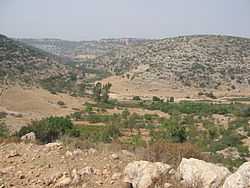
Nahal Qana begins in the hills of Mount Gerizim, reaches the Sharon plain near Jaljulia and empties into the Yarkon just west of the Yarkon interchange (32°7′16.7″N 34°54′13″E / 32.121306°N 34.90361°E on Highway 5). It runs south of Immanuel, Karnei Shomron, Ma'ale Shomron, Alfei Menashe, Nirit, Kfar Saba, and Hod HaSharon and north of Yakir, Nofim, Etz Efraim, Sha'arei Tikva, Oranit, and Horshim.
History
Nahal Qana served as the boundary between the Tribe of Ephraim and the Tribe of Manasseh.[1] In the 1980s, a cave was discovered in the wadi.[2]
Nature reserve
As of 2006, the area around Nahal Qana is being considered as a nature reserve, as requested by the Israel Nature and Parks Authority. [3]
References
- ↑ Joshua 16:8
- ↑ Gopher, Avi. "The Nahal Qanah Cave: Earliest Gold in the Southern Levant". Tel Aviv University. Retrieved May 9, 2011.
- ↑ "Nahal Qana" (in Hebrew). Israel Nature and Parks Authority. Retrieved May 9, 2011.
External links
- Eldad, Karni (October 16, 2011). נחל קנה: דו-קיום תיירותי בשמורת טבע בשומרון (in Hebrew).