Nagatinsky Zaton District
| Nagatinsky zaton District | |
|---|---|
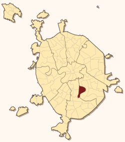
 Location of Nagatinsky zaton District on the map of Moscow | |
.png) | |
|
| |
| Location | |
| Country | Russia |
| Federal subject | Moscow |
| Statistics | |
| Time zone | MSK (UTC+03:00)[1] |
| Nagatinsky zaton District on WikiCommons | |
Nagatinsky zaton District (Russian: район Нагатинский затон) is a district in Southern Administrative Okrug of Moscow, Russia, located on the right bank of the Moskva River. The name Nagatino comes from a former village, known since the 14th century, which was engulfed by Moscow in 1960. District authorities control Kolomenskoye park, four permanently uninhabited islands on Moskva River and the peninsula of Nagatino Poima on its opposite, northern bank.
Nagatino-Sadovniki is a different district, east from Nagatinsky Zaton.
History
See Kolomenskoye for the history of this area
References
- ↑ Правительство Российской Федерации. Федеральный закон №107-ФЗ от 3 июня 2011 г. «Об исчислении времени», в ред. Федерального закона №248-ФЗ от 21 июля 2014 г. «О внесении изменений в Федеральный закон "Об исчислении времени"». Вступил в силу по истечении шестидесяти дней после дня официального опубликования (6 августа 2011 г.). Опубликован: "Российская газета", №120, 6 июня 2011 г. (Government of the Russian Federation. Federal Law #107-FZ of June 31, 2011 On Calculating Time, as amended by the Federal Law #248-FZ of July 21, 2014 On Amending Federal Law "On Calculating Time". Effective as of after sixty days following the day of the official publication.).
External links
- Russian: Official site www.uao.mos.ru
- Russian: "Official" site www.nzaton.ru
| ||||||||||||||||||||||||||||||||||||||||||||||||||||
Coordinates: 55°41′05″N 37°41′14″E / 55.68472°N 37.68722°E
