Nachikatsuura, Wakayama
| Nachikatsuura 那智勝浦町 | ||
|---|---|---|
| Town | ||
|
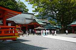
Kumano Nachi Taisha, one of World Heritage site in Japan | ||
| ||
 Location of Nachikatsuura in Wakayama Prefecture | ||
 Nachikatsuura Location in Japan | ||
| Coordinates: 33°38′N 135°56′E / 33.633°N 135.933°ECoordinates: 33°38′N 135°56′E / 33.633°N 135.933°E | ||
| Country | Japan | |
| Region | Kansai | |
| Prefecture | Wakayama Prefecture | |
| District | Higashimuro | |
| Area | ||
| • Total | 183.45 km2 (70.83 sq mi) | |
| Population (February 1, 2012) | ||
| • Total | 17,261 | |
| • Density | 94/km2 (240/sq mi) | |
| Time zone | Japan Standard Time (UTC+9) | |
| Symbols | ||
| - Tree | Live oak | |
| - Flower | Azalea | |
| Address |
Oji Tsukiji 7-1-1, Nachi-Katsuura Town, Nishimuro District, Wakayama Prefecture (和歌山県西牟婁郡那智勝浦町大字築地7丁目1番1号) 649-53921 | |
| Phone number | 81-(0)735-52-0555 | |
| Website | Town of Nachikatsuura | |

Nachikatsuura (那智勝浦町 Nachikatsuura-chō) is a town located in Higashimuro District, Wakayama Prefecture, Japan.
As of February 1, 2012, the town has an estimated population of 17,261, with 8,359 households, and a density of 94.09 persons per km². The total area is 183.45 km².
The Kumano Nachi Taisha, one of the three Kumano Shrines, is in Nachi Katsuura. These shrines form part of the "Sacred Sites and Pilgrimage Routes in the Kii Mountain Range" UNESCO World Heritage Site.
-

Nanki-Katsuura Onsen: Japanese open air hot spring in Nachikatsuura, Wakayama
-

Pagoda in Seiganto Temple and Kumano Nachi Water Fall
External links
![]() Media related to Nachikatsuura, Wakayama at Wikimedia Commons
Media related to Nachikatsuura, Wakayama at Wikimedia Commons