Nabinagar Upazila
| Nabinagar নবীনগর | |
|---|---|
| Upazila | |
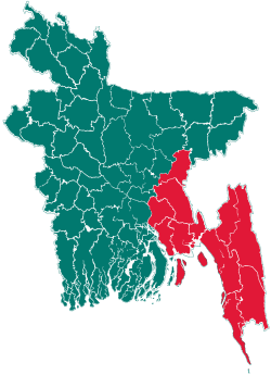
 Nabinagar Location in Bangladesh | |
| Coordinates: 23°53′N 90°59′E / 23.883°N 90.983°ECoordinates: 23°53′N 90°59′E / 23.883°N 90.983°E | |
| Country |
|
| Division | Chittagong Division |
| District | Brahmanbaria District |
| Area | |
| • Total | 350.32 km2 (135.26 sq mi) |
| Population (2011) | |
| • Total | 493,518 |
| • Density | 1,409/km2 (3,650/sq mi) |
| Time zone | BST (UTC+6) |
| Website | Official Map of Nabinagar |
Nabinagar (Bengali: নবীনগর ) is an Upazila of Brahmanbaria District in the Division of Chittagong, Bangladesh.
Geography
Nabinagar is located at 23°53′00″N 90°59′00″E / 23.8833°N 90.9833°E. It has 94,871 households and a total area of 86,568 acres (350.328 km²).
Demographics
According to the 2011 Bangladesh census, Nabinagar had a population of 493,518. This comprised 230,227 males and 263,291 females, with males constituting 46.65% of the population, and females 53.35%. Nabinagar has an average literacy rate of 43.60%, comprising 42.80% among males and 44.30% among females. Bangladesh Bureau of Statistics
Administration
Nabinagar Thana was turned into an upazila in 1983. Nabinagar has 1 pouroshova, 21 Unions/Wards, 261 Mauzas/Mahallas, and 217 villages.Current Member of Parliament : Fayzur Rahman ( Brahmanbaria-5)
Educational Institutions
There are 4 colleges, 25 high schools, 8 Madrasas, 144 government primary schools and 55 non-government primary schools. The noted educational institutions are Nabinagar Pilot High School (1896) and Bidyakut Amar High School (1913).
Media
The Weekly Malaya is a local newspaper serving the Nabinagar Upazila region.
See also
References
External links
| |||||||||||||||||||||||||||||||||||||||||||||||||||||