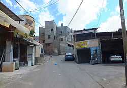
Nabi Ilyas
| an Nabi Elyas | |
|---|---|
| Other transcription(s) | |
| • Arabic | خربة النبي الياس |
| • Also spelled |
Nabi Ilyas (official) Kherbit an-Nabi al-Yas (unofficial) |
 | |
 an Nabi Elyas Location of an Nabi Elyas within Palestine | |
| Coordinates: 32°10′21.11″N 35°02′00.00″E / 32.1725306°N 35.0333333°ECoordinates: 32°10′21.11″N 35°02′00.00″E / 32.1725306°N 35.0333333°E | |
| Governorate | Qalqilya |
| Government | |
| • Type | Village council |
| Population (2006) | |
| • Jurisdiction | 1,214 |
| Name meaning | The prophet Elias[1] |
Nabi Ilyas (Arabic: خربة النبي الياس; Hebrew: נבי אליאס) is a Palestinian village in the Qalqilya Governorate in the western West Bank, located two kilometers east of Qalqilya. According to the Palestinian Central Bureau of Statistics, an Nabi Ilyas had a population of approximately 1,214 inhabitants in mid-year 2006.[2] 25.6% of the population of an Nabi Ilyas were refugees in 1997.[3]
The health care facilities for an Nabi Ilyas are in Qalqilya designated as MoH level 4 there are also two clinics one run by the UNRWA and one run by the Palestinian Ministry of Health.[4]
Although security concerns during a Palestinian uprising that began in 2000 kept Israeli shoppers away for years, with attacks by militants on Israelis now rare in the West Bank, Israeli consumers are venturing back to an area once known as a bargain-hunter's paradise. Nabi Elyas is profiting from an influx of Jewish shoppers drawn by cheap prices and still kept out of the main Palestinian cities by Israeli security regulations. Groceries, furniture and even dental treatment are on offer in Nabi Elyas, which is packed with cars from Israel, especially during weekends.[5][6]
History
In 1882 the Palestine Exploration Fund's Survey of Western Palestine described Neby Elyas (under "Archæology") as: "Walls and wells, with a ruined kubbeh."[7]
Footnotes
- ↑ Palmer, 1881, p. 188
- ↑ Projected Mid -Year Population for Qalqilya Governorate by Locality 2004- 2006 Palestinian Central Bureau of Statistics.
- ↑ Palestinian Population by Locality and Refugee Status Palestinian Central Bureau of Statistics
- ↑ Health care Facilities West Bank
- ↑ Mohammed Assadi (Apr 26, 2009). "Palestinian village welcomes Israeli shoppers". Reuters.
- ↑ Palestinian village profits from influx of Israeli shoppers Haaretz
- ↑ Conder and Kitchener, 1882, p. 210
Bibliography
- Conder, Claude Reignier; Kitchener, H. H. (1882). The Survey of Western Palestine: Memoirs of the Topography, Orography, Hydrography, and Archaeology 2. London: Committee of the Palestine Exploration Fund.
- Hadawi, Sami (1970), Village Statistics of 1945: A Classification of Land and Area ownership in Palestine, Palestine Liberation Organization Research Center
- Palmer, E. H. (1881). The Survey of Western Palestine: Arabic and English Name Lists Collected During the Survey by Lieutenants Conder and Kitchener, R. E. Transliterated and Explained by E.H. Palmer. Committee of the Palestine Exploration Fund.
External links
- SWP map 11, IAA
- SWP map 11, Wikimedia commons
- An Nabi Elyas Village (Fact Sheet), ARIJ
- An Nabi Elyas Village Profile, ARIJ
- An Nabi Elyas, areal photo, ARIJ
| ||||||||||||||||
