Mynydd Moel
| Mynydd Moel | |
|---|---|
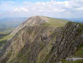 Mynydd Moel from Cadair Idris | |
| Elevation | 863 m (2,831 ft) |
| Prominence | 67 m (220 ft) |
| Parent peak | Cadair Idris |
| Listing | Hewitt, Nuttall |
| Translation | Bare Mountain (Welsh) |
| Location | |
| Location | Gwynedd, Wales |
| Range | Cadair Idris |
| OS grid | SH711130 |
| Topo map | OS Landranger 124, Explorer OL23 |
| Climbing | |
| Easiest route | Hike |
Mynydd Moel is a subsidiary summit of Cadair Idris in the Snowdonia National Park, in Gwynedd, northwest Wales. It lies to the east of Cadair Idris and is often climbed as a horseshoe along with Craig Cwm Amarch and Cadair Idris.
The summit bare an rocky and marked with a cairn. The north face like Cadair Idris has large cliffs. To the east is a lower broad plateau topped by the summit of Gau Graig.[1]
References
- ↑ Nuttall, John & Anne (1999). The Mountains of England & Wales - Volume 1: Wales (2nd edition ed.). Milnthorpe, Cumbria: Cicerone. ISBN 1-85284-304-7.
External links
Coordinates: 52°41′58″N 3°54′25″W / 52.699428°N 3.907032°W