Murray Valley Highway
| Murray Valley Highway New South Wales – Victoria | |
|---|---|
 | |
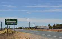
| Murray Valley Highway at Nathalia | |
 | |
| General information | |
| Type | Highway |
| Length | 663 km (412 mi) |
| Route number(s) |
|
| Former route number |
|
| Major junctions | |
| NW end | |
| |
| SE end |
|
| Location(s) | |
| Major settlements | Robinvale, Swan Hill, Kerang, Echuca, Yarrawonga, Wodonga, Tallangatta |
| Highway system | |
|
Highways in Australia National Highway • Freeways in Australia Highways in New South Wales Highways in Victoria | |
The Murray Valley Highway[1][2] is a state highway that is located in Victoria and New South Wales, Australia.
Route
The Murray Valley Road was built in the late 1920s and early 1930s by the Country Roads Board of Victoria as part of a program of rural roads to facilitate development of the more remote parts of the state and provide connections between communities in addition to the roads and railways radiating out from Melbourne. It is one of a number of roads designated as a State Highway in 1933.[3] At that time, the highway ran from Corryong to the South Australian border. The western end of this route is now part of the Sturt Highway.
The popular tourist route follows the south side of the Murray River and effectively acts as the northern-most highway in Victoria. The western end of route B400 is the Murray River bridge at Robinvale, although the Murray Valley Highway crosses that bridge without the B400 designation (formerly as National Route 16[4]) to connect with the Sturt Highway 2 kilometres (1.2 mi) further north. Historically, the Murray Valley Highway continued west to connect with the Calder Highway at Hattah instead of crossing the river. The eastern end is in the foothills of the Great Dividing Range at Corryong. There has also been a contemporary re-alignment of the eastern end; whereby the highway used to go through Thologogong, Walwa and Towong (the current Murray River Road C546).
The route also extends further east and crosses the border into New South Wales as the Alpine Way.
Most of the highway is fairly straight and flat, much of it through irrigated farmland. It becomes hillier and more winding east of Wodonga, with a moderately steep mountain pass near Koetong, between Tallangatta and Corryong.
The major towns along the route are Robinvale, Swan Hill, Kerang, Cohuna, Echuca, Nathalia, Strathmerton, Cobram, Yarrawonga, Rutherglen, Wodonga, Tallangatta and Corryong.
Major intersections and towns
| Murray Valley Highway | |||
| Northbound | Distance to Mildura (km) |
Distance to Melbourne (km) |
Southbound |
| Sturt Highway Sturt Highway | |||
| End Murray Valley Highway | 81 | 475 | Start Murray Valley Highway |
| Murray River | 84 | 472 | Murray River |
| NEW SOUTH WALES STATE BORDER VICTORIA | |||
| End |
84 | 472 | Start |
| Robinvale | 85 | 471 | Robinvale |
| Manangatang, Sea Lake Robinvale-Sea Lake Road |
87 | 469 | Manangatang, Sea Lake Robinvale-Sea Lake Road |
| Hattah Hattah-Robinvale Road |
102 | 454 | Hattah Hattah-Robinvale Road |
| continues as |
175 | 381 | Tooleybuc, Balranald, Sydney Tooleybuc Road |
| Tooleybuc, Balranald, Sydney Tooleybuc Road |
| ||
| |
177 | 379 | Ouyen, Adelaide Mallee Highway |
| Ouyen, Adelaide Mallee Highway |
continues as | ||
| Nyah | 192 | 364 | Nyah |
| Northbound | Distance to Swan Hill (km) |
Distance to Melbourne (km) |
Southbound |
| Town Centre, Sea Lake Sea Lake-Swan Hill Road Moulamein, Deniliquin Moulamein Road |
0 | 337 | Swan Hill |
| Swan Hill | Moulamein, Deniliquin Moulamein Road Town Centre, Sea Lake Sea Lake-Swan Hill Road | ||
| Wycheproof, Donald Donald-Swan Hill Road |
5 | 332 | Wycheproof, Donald Donald-Swan Hill Road |
| Lake Boga | 16 | 321 | Lake Boga |
| To Quambatook, Donald Kerang-Quambatook Road |
57 | 280 | To Quambatook, Donald Kerang-Quambatook Road |
| To Town Centre, Koondrook Kerang-Koondrook Road |
59 | 278 | Kerang |
| Kerang | To Town Centre, Koondrook Kerang-Koondrook Road | ||
| Bendigo, Melbourne Loddon Valley Highway |
62 | 275 | Bendigo, Melbourne Loddon Valley Highway |
| Westbound | Distance to Swan Hill (km) |
Distance to Echuca (km) |
Eastbound |
| Koondrook, Barham Cohuna-Koondrook Road |
89 | 63 | Koondrook, Barham Cohuna-Koondrook Road |
| Leitchville Cohuna-Leitchville Road |
91 | 61 | Cohuna |
| Cohuna | Leitchville, Pyramid Hill Cohuna-Leitchville Road | ||
| Leitchville, Pyramid Hill Kerang-Leitchville Road |
106 | 46 | Leitchville, Pyramid Hill Kerang-Leitchville Road |
| Town Centre, Moama Warren Street |
152 | 0 | Echuca |
| Town Centre, Moama Warren Street | |||
| Westbound | Distance to Swan Hill (km) |
Distance to Wodonga (km) |
Eastbound |
| continues as |
154 | 236 | Rochester, Bendigo, Melbourne Northern Highway |
| Rochester, Bendigo, Melbourne Northern Highway |
| ||
| |
156 | 234 | Town Centre, Moama, Deniliquin Northern Highway |
| Town Centre, Moama, Deniliquin Northern Highway |
continues as | ||
| Westbound | Distance to Echuca (km) |
Distance to Wodonga (km) |
Eastbound |
| Kyabram Echuca-Kyabram Road |
0 | 233 | Kyabram Echuca-Kyabram Road |
| Echuca | |||
| Tongala, Kyabram Kyabram-Tongala Road |
18 | 215 | Tongala, Kyabram Kyabram-Tongala Road |
| Kyabram John Allen Road |
28 | 205 | Kyabram John Allen Road |
| To Shepparton Echuca-Mooroopna Road |
30 | 203 | To Shepparton Echuca-Mooroopna Road |
| GOULBURN RIVER | 36 | 197 | GOULBURN RIVER |
| Shepparton, Barmah Barmah-Shepparton Road |
51 | 182 | Barmah, Shepparton Barmah-Shepparton Road |
| Numurkah, Katamatite Katamatite-Nathalia Road |
54 | 179 | Numurkah, Katamatite Katamatite-Nathalia Road |
| Nathalia | 55 | 178 | Nathalia |
| continues as |
89 | 144 | Numurkah, Shepparton, Melbourne Goulburn Valley Highway |
| Numurkah, Shepparton, Melbourne Goulburn Valley Highway |
| ||
| Strathmerton | 93 | 140 | Strathmerton |
| |
103.2 | 129.8 | Tocumwal, Brisbane Goulburn Valley Highway |
| Tocumwal, Brisbane Goulburn Valley Highway |
continues as | ||
| Benalla Benalla-Tocumwal Road |
103.3 | 129.7 | Katamatite, Benalla Benalla-Tocumwal Road |
| Katamatite, Benalla Cobram South Road |
107 | 126 | Benalla Cobram South Road |
| To Town Centre, Tocumwal Cobram-Koonoomoo Road |
108 | 125 | Cobram |
| Cobram | To Town Centre, Tocumwal Cobram-Koonoomoo Road | ||
| continues as |
144 | 89 | To Benalla Benalla-Yarrawonga Road |
| To Benalla Benalla-Yarrawonga Road |
| ||
| |
145 | 88 | Yarrawonga |
| Town Centre, Mulwala, Corowa Belmore Street |
Town Centre, Mulwala, Corowa Belmore Street | ||
| Yarrawonga | continues as | ||
| Wangaratta Wangaratta-Yarrawonga Road |
164 | 69 | Wangaratta Wangaratta-Yarrawonga Road |
| Wangaratta, Corowa Three Chain Road |
186 | 47 | Wahgunyah, Corowa, Wangaratta Three Chain Road |
| continues as |
190 | 43 | Rutherglen |
| Wahgunyah, Corowa Rutherglen-Wahgunyah Road |
Wahgunyah, Corowa Rutherglen-Wahgunyah Road | ||
| | |||
| |
191 | 42 | Springhurst, Chiltern Chiltern-Rutherglen Road |
| Springhurst, Chiltern Chiltern-Rutherglen Road | |||
| Rutherglen | continues as | ||
| Chiltern, Howlong Chiltern-Howlong Road |
206 | 27 | Howlong, Chiltern Chiltern-Howlong Road |
| Howlong Barnawartha-Howlong Road |
212 | 21 | Howlong Barnawartha-Howlong Road |
| Murray Valley Highway continues from Hume Freeway |
218 | 15 | Wangaratta, Melbourne Hume Freeway |
| continues as Hume Freeway to Wodonga | |||
| Westbound | Distance to Melbourne (km) |
Distance to Corryong (km) |
Eastbound |
| continues as Hume Freeway to Melbourne |
319 | 123 | Murray Valley Highway duplexes with Old Hume Highway and continues from Hume Freeway |
| Albury Old Hume Highway Bandiana Link Sydney Hume Freeway | |||
| |
320 | 122 | Wodonga |
| Town Centre, Beechworth Old Hume Highway |
Town Centre, Beechworth Old Hume Highway | ||
| Wodonga | continues as | ||
| Albury, Sydney Bandiana Link |
324 | 118 | Albury, Sydney Bandiana Link |
| Mount Beauty, Falls Creek Kiewa Valley Highway |
326 | 116 | Mount Beauty, Falls Creek Kiewa Valley Highway |
| Hume Dam Bonegilla Road |
333 | 109 | Hume Dam Bonegilla Road |
| To Tangambalanga Kiewa East Road |
349 | 93 | Tangambalanga, Yackandandah Kiewa East Road |
| Tallangatta | 361 | 81 | Tallangatta |
| Omeo, Bairnsdale Omeo Highway |
367 | 75 | Omeo, Bairnsdale Omeo Highway |
| Granya Murray River Road |
377 | 65 | Granya Murray River Road |
| Walwa, Jingellic Shelley-Jingellic Road |
404 | 38 | Walwa, Jingellic Shelley-Jingellic Road |
| Cudgewa, Tintaldra Cudgewa-Tintaldra Road |
425 | 17 | Cudgewa, Tintaldra Cudgewa-Tintaldra Road |
| Benambra, Omeo, Mount Hotham, Bairnsdale Benambra-Corryong Road |
435 | 7 | Benambra, Omeo Benambra-Corryong Road |
| Corryong | 442 | 0 | Corryong |
| Westbound | Distance to Melbourne (km) |
Distance to Jindabyne (km) |
Eastbound |
| Towong, Tintaldra Murray River Road |
449 | 129 | Towong, Tintaldra Murray River Road |
| Start Murray Valley Highway from Alpine Way |
456 | 122 | End Murray Valley Highway |
| VICTORIA STATE BORDER NEW SOUTH WALES | |||
| Murray River | 456 | 122 | Murray River |
| continues as Alpine Way to Jindabyne and Cooma | |||
Sources
Murray Valley Highway on Google Maps
See also
| Wikimedia Commons has media related to Murray Valley Highway. |
- Highways in Australia
- Highways in New South Wales
- Highways in Victoria
References
- ↑ Australian Towns, Cities & Highways: Murray Valley Highway, Hotkey. Retrieved on 11 May 2008.
- ↑ Murray Valley Highway, ExplorOz. Retrieved on 11 May 2008.
- ↑ Twentieth Annual Report for year ended 30th June 1933, Country Roads Board, p. 4
- ↑ National Route 16 – Murray Valley Highway, Ozroads. Retrieved on 22 September 2013.
| ||||||||||||||||||||