Muret
| Muret | |
|---|---|
|
Town hall | |
 Muret | |
|
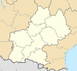
Location within Midi-Pyrénées region  Muret | |
| Coordinates: 43°27′40″N 1°19′36″E / 43.4611°N 1.3267°ECoordinates: 43°27′40″N 1°19′36″E / 43.4611°N 1.3267°E | |
| Country | France |
| Region | Midi-Pyrénées |
| Department | Haute-Garonne |
| Arrondissement | Muret |
| Canton | Muret |
| Intercommunality | Muretain |
| Government | |
| • Mayor (2001–2008) | Alain Barrès |
| Area1 | 57.84 km2 (22.33 sq mi) |
| Population (2008)2 | 23,297 |
| • Density | 400/km2 (1,000/sq mi) |
| INSEE/Postal code | 31395 / 31600 |
| Elevation |
152–305 m (499–1,001 ft) (avg. 169 m or 554 ft) |
|
1 French Land Register data, which excludes lakes, ponds, glaciers > 1 km² (0.386 sq mi or 247 acres) and river estuaries. 2 Population without double counting: residents of multiple communes (e.g., students and military personnel) only counted once. | |
Muret (French pronunciation: [my.ʁɛ] ; in Occitan Murèth) is a commune in the Haute-Garonne department in southwestern France.
It is an outer suburb of the city of Toulouse, even though it does not belong to Greater Toulouse, which it has declined to join. It lies southwest of Toulouse and is the largest component of the intercommunality of Muretain.
History
On September 12, 1213 the Battle of Muret took place between Simon de Montfort and a coalition force under the control of Count Raymond of Toulouse, and King Pere II of Aragon.
De Montfort had been fighting Albigensian heretics during the Albigensian Crusade, when he was besieged by the vastly superior coalition army. Refusing to surrender or be starved into submission, de Montfort went on the offensive. Leading his knights out of the town, he proceeded to position them in a wide arc, then fell upon the Toulouse cavalry with a noise like a whole forest going down under the axe. Next to fall before the Crusader army was the Aragonian cavalry, where King Pere himself fell to the sword. After this, all that was left was to scatter the remaining cavalry defending the coalition camp before turning on the infantry that had been besieging Muret's walls. Despite their overwhelming advantage in numbers,the coalition army numbering almost 34,000 men was destroyed by de Montfort's army of only 2,100. The siege of Muret was lifted.
7,000-20,000 coalition troops were killed compared to a handful of casualties for de Monfort's army.
Population
| Historical population | ||
|---|---|---|
| Year | Pop. | ±% |
| 1793 | 3,000 | — |
| 1800 | 3,258 | +8.6% |
| 1806 | 3,284 | +0.8% |
| 1821 | 3,286 | +0.1% |
| 1831 | 3,787 | +15.2% |
| 1836 | 3,972 | +4.9% |
| 1841 | 4,000 | +0.7% |
| 1846 | 4,308 | +7.7% |
| 1851 | 4,196 | −2.6% |
| 1856 | 4,125 | −1.7% |
| 1861 | 4,130 | +0.1% |
| 1866 | 4,050 | −1.9% |
| 1872 | 3,852 | −4.9% |
| 1876 | 3,956 | +2.7% |
| 1881 | 4,056 | +2.5% |
| 1886 | 4,145 | +2.2% |
| 1891 | 4,142 | −0.1% |
| 1896 | 4,064 | −1.9% |
| 1901 | 3,911 | −3.8% |
| 1906 | 3,712 | −5.1% |
| 1911 | 3,654 | −1.6% |
| 1921 | 3,218 | −11.9% |
| 1926 | 3,482 | +8.2% |
| 1931 | 3,725 | +7.0% |
| 1936 | 4,013 | +7.7% |
| 1946 | 4,368 | +8.8% |
| 1954 | 5,204 | +19.1% |
| 1962 | 6,693 | +28.6% |
| 1968 | 13,039 | +94.8% |
| 1975 | 14,778 | +13.3% |
| 1982 | 15,844 | +7.2% |
| 1990 | 18,134 | +14.5% |
| 1999 | 20,735 | +14.3% |
| 2008 | 23,297 | +12.4% |
Sights
The Château de Rudelle is a 16th and 17th century castle. Privately owned, it is listed as a historic site by the French Ministry of Culture.[1]
Geography
The Louge flows northeast through the commune, then flows into the Garonne in the town.
The Garonne flows north through the commune and forms part of its northern border.
Transport
Communication
South of Muret, there is a mediumwave broadcasting station, which works on 945 kHz with 300 kW.
International relations
Muret is twinned with:
Education
See also
- Battle of Muret
- Communes of the Haute-Garonne department
- Parc naturel régional des Landes de Gascogne
References
- ↑ www.culture.gouv.fr, accessed 17 March 2008
External links
| Wikimedia Commons has media related to Muret. |
- Official website (in French)