Murat, Allier
| Murat | |
|---|---|
|
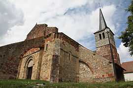
The church in Murat | |
 Murat | |
|
Location within Auvergne region  Murat | |
| Coordinates: 46°24′12″N 2°54′42″E / 46.4033°N 2.9117°ECoordinates: 46°24′12″N 2°54′42″E / 46.4033°N 2.9117°E | |
| Country | France |
| Region | Auvergne |
| Department | Allier |
| Arrondissement | Montluçon |
| Canton | Montmarault |
| Intercommunality | Région de Montmarault |
| Government | |
| • Mayor (2001–2008) | Bernard Philippe |
| Area1 | 20.07 km2 (7.75 sq mi) |
| Population (2008)2 | 280 |
| • Density | 14/km2 (36/sq mi) |
| INSEE/Postal code | 03191 / 03390 |
| Elevation |
247–360 m (810–1,181 ft) (avg. 314 m or 1,030 ft) |
|
1 French Land Register data, which excludes lakes, ponds, glaciers > 1 km² (0.386 sq mi or 247 acres) and river estuaries. 2 Population without double counting: residents of multiple communes (e.g., students and military personnel) only counted once. | |
Murat is a commune in the Allier department in central France.
Population
| Historical population | ||
|---|---|---|
| Year | Pop. | ±% |
| 1962 | 370 | — |
| 1968 | 409 | +10.5% |
| 1975 | 334 | −18.3% |
| 1982 | 295 | −11.7% |
| 1990 | 301 | +2.0% |
| 1999 | 311 | +3.3% |
| 2008 | 280 | −10.0% |
See also
References
| Wikimedia Commons has media related to Murat, Allier. |