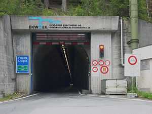
Munt la Schera Tunnel
 | |
| Overview | |
|---|---|
| Location | Grisons, Switzerland |
| Coordinates | 46°38′6″N 10°11′55″E / 46.63500°N 10.19861°ECoordinates: 46°38′6″N 10°11′55″E / 46.63500°N 10.19861°E |
| Operation | |
| Opened |
1965 (for private use) 1968 (for public use) |
| Character | road, one-way |
| Technical | |
| Length | 3,394 metres (11,135 ft) |
| Number of lanes | 1 |
| Highest elevation | 1,809 metres (5,935 ft) |
| Lowest elevation | 1,711 metres (5,614 ft) |
The Munt la Schera Tunnel is a single lane road tunnel located in the Swiss canton of Grisons. It connects the Engadin valley with Lago di Livigno, through Munt la Schera. Completed in 1965, the tunnel is 3,394 metres (11,135 ft) in length.[1]
The tunnel was built to transport building materials for the construction of Punt dal Gall dam. It was opened for public use in 1968, but is still owned and operated by the Engadiner Kraftwerke AG. The tunnel is only wide enough for a single vehicle, and traffic moves in alternate directions controlled by traffic lights which change every fifteen minutes. The tunnel is subject to height and width maxima of 3.6 metres (12 ft) and 2.5 metres (8 ft 2 in) respectively. The tunnel is open 24 hours a day, but for safety reasons is closed to cyclists. From June to September, cyclists may take their cycles on a half hourly shuttle bus, whilst at other times they may use a limited number of places on the public bus service.[2]
As of 2014, the toll for a one way vehicle trip in the summer through the tunnel is CHF16/EUR13. In winter a higher rate may be levied.[3][4]
References
- ↑ "Munt la Schera Tunnel (Grisons, 1965)". structurae.net. Retrieved 2014-07-19.
- ↑ "Tunnel Livigno - Opening Times". Engadiner Kraftwerke AG. Retrieved 2014-07-19.
- ↑ "Tunnel Munt La Schera - Price list Summer - valid from May 1st 2014". Engadiner Kraftwerke AG. Retrieved 2014-07-19.
- ↑ "Tunnel Munt la Schera". Chalet Claudia. Retrieved 2014-07-19.
External links
-
 Media related to Munt la Schera Tunnel at Wikimedia Commons