Municipalities of Liechtenstein
 |
| This article is part of a series on the politics and government of Liechtenstein |
|
Politics portal |
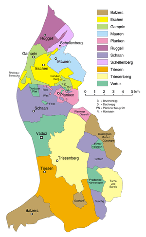
The principality of Liechtenstein is divided into eleven municipalities (Gemeinden – singular Gemeinde), most consisting of only a single town. Five of the Gemeinden fall within the electoral district Unterland (lower country), the remainder are within Oberland (upper country).
Municipalities
| Coat of arms | Postal Code and Name |
Population (Dec. 31, 2013) |
Area in km² |
Towns/Villages |
|---|---|---|---|---|
| Electoral District Unterland | ||||
| | 9491 Ruggell | 2092 | 7,4 | Ruggell |
| | 9488 Schellenberg | 1032 | 3,5 | Schellenberg |
| | 9487 Gamprin | 1649 | 6,1 | Gamprin Bendern |
| | 9492 Eschen | 4259 | 10,3 | Eschen Nendeln |
| | 9493 Mauren | 4142 | 7,5 | Mauren Schaanwald |
| Electoral District Oberland | ||||
| | 9494 Schaan | 5927 | 26,8 | Schaan Mühleholz |
| | 9498 Planken | 421 | 5,3 | Planken Hinterschellenberg |
| | 9490 Vaduz | 5372 | 17,3 | Vaduz Ebenholz |
| | 9497 Triesenberg | 2621 | 29,8 | Triesenberg Gaflei, Malbun, Masescha, Rotenboden, Samina, Silum, Steg, Sücka, Wangerberg |
| | 9495 Triesen | 4989 | 26,4 | Triesen |
| | 9496 Balzers | 4592 | 19,6 | Balzers Mäls |
| | Liechtenstein | 37132 | 160,0 | |
Exclaves and Enclaves
The municipalities of Liechtenstein, the Gemeinden, exhibit complex shapes, despite their small size.
Seven of the Gemeinden have one or more exclaves, in addition to the main territory:
- Balzers: 2 exclaves
- Eschen: 2 exclaves
- Gamprin: 1 exclave
- Planken: 4 exclaves, of which 1 is a true enclave
- Schaan: 4 exclaves, of which 1 is a true enclave
- Triesenberg: 1 exclave (around the town of Malbun)
- Vaduz: 6 exclaves, of which 2 are true enclaves
Data codes
In ISO 3166-2, the codes of the municipalities start with LI-, followed by two digits (01–11, assigned in alphabetical order).
In FIPS 10-4 (standard withdrawn in 2008), the codes of the municipalities started with LS-, followed by the same two digits as the ISO codes.
As a member of the EFTA, Liechtenstein is included in the Nomenclature of Territorial Units for Statistics (NUTS). The three NUTS levels all correspond to the country itself (NUTS-1: LI0; NUTS-2: LI00; NUTS-3: LI000). Below the NUTS levels, there are two LAU levels (LAU-1: electoral districts; LAU-2: municipalities).
External links
- Communes of Liechtenstein, Statoids.com
| ||||||||||||||||