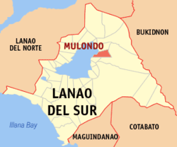
Mulondo, Lanao del Sur
| Mulondo | |
|---|---|
| Municipality | |
 Map of Lanao del Sur with Mulondo highlighted | |
.svg.png) Mulondo Location within the Philippines | |
| Coordinates: 07°56′N 124°23′E / 7.933°N 124.383°ECoordinates: 07°56′N 124°23′E / 7.933°N 124.383°E | |
| Country | Philippines |
| Region | Autonomous Region in Muslim Mindanao (ARMM) |
| Province | Lanao del Sur |
| Barangays | 26 |
| Government[1] | |
| • Mayor | Machol B. Abdulsalam |
| Area | |
| • Total | 458.67 km2 (177.09 sq mi) |
| Population (2010)[2] | |
| • Total | 14,065 |
| • Density | 31/km2 (79/sq mi) |
| Time zone | PST (UTC+8) |
| ZIP code | 9702 |
| Dialing code | 63 |
| Income class | 3rd |
Mulondo is a third class municipality in the province of Lanao del Sur, Philippines. According to the 2010 census, it has a population of 14,065 people.[2]
Etymology
Its name is derived from the Maranao dialect, which means "People of Lake"
Geography
Formerly known as Bato Intan, it is geographically situated east from Masiu, one of the four (4) Principalities of Lanao (Pangampong A Ranao), the governing bodies of the Lanao Sultanate. Strategically located in the 1st District of Lanao del Sur where it is partially urban.
Barangays
Mulondo is politically subdivided into 26 barangays.
- Bangon
- Bubonga Guilopa
- Buadi-Abala
- Buadi-Bayawa
- Buadi-Insuba
- Bubong
- Cabasaran
- Cairatan
- Cormatan
- Poblacion (Dado)
- Dalama
- Dansalan
- Dimarao
- Guilopa
- Ilian
- Kitambugun
- Lama (Bagoaingud)
- Lilod
- Lilod Raybalai
- Lumbaca Ingud
- Lumbac (Lumbac Bubong)
- Madaya
- Pindolonan
- Salipongan
- Sugan
- Bagoaingud
Demographics
| Population census of Mulondo | ||
|---|---|---|
| Year | Pop. | ±% p.a. |
| 1990 | 11,135 | — |
| 1995 | 11,866 | +1.20% |
| 2000 | 12,368 | +0.89% |
| 2007 | 16,458 | +4.02% |
| 2010 | 14,065 | −5.56% |
| Source: National Statistics Office[2] | ||
References
- ↑ "Official City/Municipal 2013 Election Results". Intramuros, Manila, Philippines: Commission on Elections (COMELEC). 1 July 2013. Retrieved 5 September 2013.
- ↑ 2.0 2.1 2.2 "Total Population by Province, City, Municipality and Barangay: as of May 1, 2010". 2010 Census of Population and Housing. National Statistics Office. Retrieved 20 June 2014.
External links
- Philippine Standard Geographic Code
- Philippine Census Information
- Local Governance Performance Management System
 |
Buadiposo-Buntong |  | ||
| Lake Lanao | |
Maguing | ||
| ||||
| | ||||
| Taraka / Maguing |