Mullumbimby, New South Wales
| Mullumbimby New South Wales | |
|---|---|
|
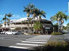
Burringbar Street—Mullumbimby's main street | |
|
Mullumbimby | |
| Coordinates | 28°33′S 153°30′E / 28.550°S 153.500°ECoordinates: 28°33′S 153°30′E / 28.550°S 153.500°E |
| Population | 3,172 (2011 census)[1] |
| Postcode(s) | 2482 |
| Location |
|
| LGA(s) | Byron Shire |
| State electorate(s) | Ballina[2] |
| Federal Division(s) | Richmond[3] |

Mullumbimby is a town in the Northern Rivers region of New South Wales, Australia in Byron Shire. It promotes itself as The Biggest Little Town in Australia.[4] The town lies at the foot of Mount Chincogan in the Brunswick Valley about 10 kilometres (6 miles) from the coast. At the 2011 census, Mullumbimby and the surrounding area had a population of 3,172 people.[1] Locals refer to the town as "Mullum".
Origins

Originally occupied by the Bundjalung people, by the 1850s a British camp site was established at the junction of the three arms of the Brunswick River. This grew to become a village and later the township of Mullumbimby. The name was given to the district by Aboriginal people possibly because of the proximity of Mount Chincogan.[5][6] It is alternatively believed to refer to a small round hill on Mainarm Rd (and not referring to Chincogan, the local landmark). The name of this small round hill is derived from the Bandjalung-Yugambeh dialect 'mulubinba' (pertaining to a native fern which grew there).[7]
It was an excellent site because the river was tidal and could be easily navigated to that point. Its central location gave access to all areas of the catchment area and it provided the best position for bullock teams to cross the river with their wagons loaded with timber. At low tide it is still possible to see the shallow region where the bullocks made the crossing of the Brunswick River.
Geography

Mullumbimby is about 4 kilometres (2 mi) west of the Pacific Highway, near where the now closed Murwillumbah railway line crosses the Brunswick River. The line opened in 1894 and was closed in 2004 because of an argument over funding between Federal and State politicians, despite community resistance across the region. Closure of the railway line between Murwillumbah and Casino has reduced transport options in the region. Mullumbimby is close to the localities of Ocean Shores, Brunswick Heads and Wilsons Creek.
Culture and history

Mullumbimby was a separate municipality from 1908 until 1980 when it was forced to amalgamate with the Byron Shire. The Byron Shire Council offices were relocated to Mullumbimby in the 1990s.
Byron Shire, including Mullumbimby and nearby Byron Bay, became a centre of alternative or counter culture alongside the extant mainstream culture in the 1970s and 1980s, and remains so today. Mullumbimby is also a farming community, with a number of banana, cane, cattle and dairy farms around the township.
A static inverter plant of HVDC Directlink is located near Mullumbimby. This inverter plant was previously the site of a hydroelectric power scheme generating electricity, that powered Mullumbimby and Byron Bay from 1926, using water from a weir in nearby Wilsons Creek.[8] The hydroelectric scheme was designed by William Corin (1867–1929).[9]
Health
Mullumbimby hosts an anti-vaccination group. As of 2013, the town 's vaccination rate was the lowest in Australia, with only 46% to 49% of one, two and five year-old children in the 2482 postcode fully immunised, in contrast with a state average in the low 90s. Richmond Valley, a region close to Mullumbimby, had the lowest overall vaccination rate, in part due to a high number of "conscientious objectors" to the practice. Health officials have cited education and timely reminders as key factors in improving the vaccination rate.[10][11]
Byron Shire, in which Mullumbimby is situated, is also the only remaining local government area in the Northern Rivers region to reject fluoridation of its water supply.[12]
Notable people
- Petria Thomas, Olympic gold medalist (born 1975)
- Iggy Azalea, rapper (born 1990)
- Edwin Wilson, author 'Mullumbimby Dreaming' and 'The Mullumbimby Kid' (born 1942)
References
- ↑ 1.0 1.1 Australian Bureau of Statistics (31 October 2012). "Mullumbimby (State Suburb)". 2011 Census QuickStats. Retrieved 10 April 2015.
- ↑ "NSW Electoral District - Ballina". Electoral Commission NSW. Retrieved 10 April 2015.
- ↑ "Federal Division - Richmond". Australian Electoral Commission. 2007.
- ↑ "Mullumbimby". Byron Bay Beaches. Retrieved 20 May 2011.
- ↑ "Byron Bay Hinterland". Australian Traveller. Retrieved 11 May 2011.
- ↑ "PLACE NAMES.". The Australian Women's Weekly (1932-1982) (1932-1982: National Library of Australia). 13 May 1964. p. 61. Retrieved 22 February 2011.
- ↑ "Mullumbimby". Geographical Names Register (GNR) of NSW. Geographical Names Board of New South Wales. Retrieved 26 October 2011.
- ↑ "Mullumbimby". The Sydney Morning Herald. 2004-02-08.
- ↑ http://www.adb.online.anu.edu.au/biogs/A080128b.htm
- ↑ "Mullumbimby vaccination rate below 50 per cent". abc.net.au. ABC. 2013-05-20. Retrieved 2015-04-29.
- ↑ "Low vaccination rates make Northern Rivers most "dangerous" place to raise children: State Opposition". abc.net.au/local. ABC. 2014-03-28. Retrieved 2015-04-29.
- ↑ Broome, Hamish (2014-12-31). "Turbulent times in our patch". The Northern Star. APN. Retrieved 2015-04-29.
External links
| Wikimedia Commons has media related to Mullumbimby. |
- "Brunswick River catchment" (MAP). Office of Environment and Heritage. Government of New South Wales.
| ||||||||||||||||||||||||||||||||||||||