Mulloy, Oregon
| Mulloy, Oregon | |
|---|---|
| Unincorporated community | |
|
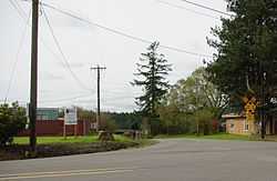
Intersection of Grahams Ferry Road and Clutter Road at Mulloy | |
 Mulloy, Oregon | |
| Coordinates: 45°20′01″N 122°47′25″W / 45.3337302°N 122.7903740°WCoordinates: 45°20′01″N 122°47′25″W / 45.3337302°N 122.7903740°W | |
| Country | United States |
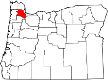
| State | Oregon |
| County | Washington |
| Elevation | 213 ft (65 m) |
| Population (1920) | |
| • Total | 59 |
| Time zone | Pacific (PST) (UTC-8) |
| • Summer (DST) | PDT (UTC-7) |
| ZIP code | 97140 |
| Area code(s) | 503 and 971 |
Mulloy is an unincorporated community in Washington County, Oregon, United States,[1] with a population of 59 in 1920.[2]
References
- ↑ Oregon Hometown Locator
- ↑ Geibergor, Charles (January 1920). It is served by the Sherwood, Oregon 97140 post office. "1920 Mulloy Precinct Census". Retrieved December 10, 2010.
| |||||||||||||||||||||||||||||