Mueang Nakhon Phanom District
| Mueang Nakhon Phanom เมืองนครพนม | |
|---|---|
| Amphoe | |
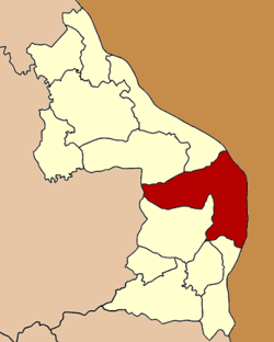 Amphoe location in Nakhon Phanom Province | |
| Coordinates: 17°22′2″N 104°45′38″E / 17.36722°N 104.76056°ECoordinates: 17°22′2″N 104°45′38″E / 17.36722°N 104.76056°E | |
| Country |
|
| Province | Nakhon Phanom |
| Seat | Nong Yat |
| Area | |
| • Total | 853.20 km2 (329.42 sq mi) |
| Population (2008) | |
| • Total | 141,997 |
| • Density | 122.7/km2 (318/sq mi) |
| Time zone | THA (UTC+7) |
| Postal code | 48000 |
| Geocode | 4801 |
Mueang Nakhon Phanom (Thai: เมืองนครพนม) is the capital district (Amphoe Mueang) of Nakhon Phanom Province, northeastern Thailand.
Geography
Neighboring districts are (from the south clockwise) That Phanom, Renu Nakhon of Nakhon Phanom Province, Kusuman of Sakon Nakhon Province, Pla Pak and Tha Uthen of Nakhon Phanom Province again. To the east across the Mekong river is the Laotian province Khammouan.
History
In 1917 the district was renamed from Mueang to Nong Buek (หนองบึก).[1] In 1938 it was renamed to Mueang Nakhon Phanom.[2]
Administration
The district is subdivided into 15 subdistricts (tambon), which are further subdivided into 169 villages (muban). The town (thesaban mueang) Nakhon Phanom covers the whole tambon Nai Mueang and Nong Saeng and parts of tambon At Samat and Nong Yat. There are further 13 Tambon administrative organizations (TAO).
| No. | Name | Thai | Villages | Inh.[3] |
|---|---|---|---|---|
| 1. | Nai Mueang | ในเมือง | - | 16,771 |
| 2. | Nong Saeng | หนองแสง | - | 4,691 |
| 3. | Na Sai | นาทราย | 13 | 5,784 |
| 4. | Na Rat Khwai | นาราชควาย | 9 | 7,277 |
| 5. | Kurukhu | กุรุคุ | 13 | 7,938 |
| 6. | Ban Phueng | บ้านผึ้ง | 23 | 15,787 |
| 7. | At Samat | อาจสามารถ | 11 | 9,771 |
| 8. | Kham Thao | ขามเฒ่า | 11 | 8,721 |
| 9. | Ban Klang | บ้านกลาง | 13 | 8,554 |
| 10. | Tha Kho | ท่าค้อ | 14 | 8,813 |
| 11. | Kham Toei | คำเตย | 18 | 12,135 |
| 12. | Nong Yat | หนองญาติ | 13 | 14,372 |
| 13. | Dong Khwang | ดงขวาง | 11 | 6,500 |
| 14. | Wang Ta Mua | วังตามัว | 11 | 8,302 |
| 15. | Pho Tak | โพธิ์ตาก | 9 | 6,581 |
References
- ↑ ประกาศกระทรวงมหาดไทย เรื่อง เปลี่ยนชื่ออำเภอ. Royal Gazette (in Thai) 34 (0 ก): 40–68. 1917-04-29.
- ↑ พระราชกฤษฎีกาเปลี่ยนนามจังหวัด และอำเภอบางแห่ง พุทธศักราช ๒๔๘๑. Royal Gazette (in Thai) 55 (0 ก): 658–666. 1938-11-14.
- ↑ "Population statistics 2008". Department of Provincial Administration.
External links
- amphoe.com (Thai)
| ||||||