Mueang Chonburi District
| Mueang Chonburi เมืองชลบุรี | |
|---|---|
| Amphoe | |
|
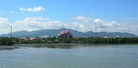
The Khao Khiao Massif rising east of Chonburi | |
 Amphoe location in Chonburi Province | |
| Coordinates: 13°21′43″N 100°58′45″E / 13.36194°N 100.97917°ECoordinates: 13°21′43″N 100°58′45″E / 13.36194°N 100.97917°E | |
| Country |
|
| Province | Chonburi |
| Seat | Bang Pla Soi |
| Tambon | 18 |
| Area | |
| • Total | 228.8 km2 (88.3 sq mi) |
| Population (2014) | |
| • Total | 316,119 |
| • Density | 1,387/km2 (3,590/sq mi) |
| Time zone | THA (UTC+7) |
| Postal code | 20000[1] |
| Geocode | 2001 |
Mueang Chonburi (Thai: เมืองชลบุรี; IPA: [mɯ̄aŋ tɕʰōn būrīː]) is the capital district (amphoe mueang) of Chonburi Province, Eastern Thailand.
Geography
Neighbouring districts are (from the north clockwise) Bang Pakong of Chachoengsao Province, Phan Thong, Ban Bueng and Si Racha. To the west is the Bay of Bangkok.
Administration
The district is subdivided into 18 subdistricts (tambon), which are further subdivided into 107 villages (muban). There are three towns (thesaban mueang) - Chonburi, Saen Suk and Ban Suan. More municipal areas are 3 townships (thesaban tambon), Khlong Tamru, Bang Sai, and Ang Sila. There are further 10 Tambon administrative organisations (TAO).
| No. | Name | Thai name | ||||||
|---|---|---|---|---|---|---|---|---|
| 1. | Bang Pla Soi | บางปลาสร้อย | 10. | Nong Mai Daeng | หนองไม้แดง | |||
| 2. | Makham Yong | มะขามหย่ง | 11. | Bang Sai | บางทราย | |||
| 3. | Ban Khot | บ้านโขด | 12. | Khlong Tamru | คลองตำหรุ | |||
| 4. | Saen Suk | แสนสุข | 13. | Mueang | เหมือง | |||
| 5. | Ban Suan | บ้านสวน | 14. | Ban Puek | บ้านปึก | |||
| 6. | Nong Ri | หนองรี | 15. | Huai Kapi | ห้วยกะปิ | |||
| 7. | Na Pa | นาป่า | 16. | Samet | เสม็ด | |||
| 8. | Nong Khang Khok | หนองข้างคอก | 17. | Ang Sila | อ่างศิลา | |||
| 9. | Don Hua Lo | ดอนหัวฬ่อ | 18. | Samnak Bok | สำนักบก |
Tourism
A number of beaches and Khao Sam Muk hill located by the Bangkok Bay seashore are important tourist attractions in Chonburi District.
Notes
- ↑ Tambon Ban Puk, Saen Suk, Mueang, muban 4 and 5 of Huai Kapi and muban 7 and 8 of Samet are handled by Bang Saen and have postal code 20130
| ||||||||||||||||||||||||||