Mueang Chiang Rai District
| Mueang Chiang Rai เมืองเชียงราย | |
|---|---|
| Amphoe | |
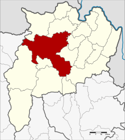 Amphoe location in Chiang Rai Province | |
| Coordinates: 19°54′31″N 99°49′57″E / 19.90861°N 99.83250°ECoordinates: 19°54′31″N 99°49′57″E / 19.90861°N 99.83250°E | |
| Country |
|
| Province | Chiang Rai |
| Area | |
| • Total | 1,216.1 km2 (469.5 sq mi) |
| Population (2005) | |
| • Total | 227,142 |
| • Density | 186.8/km2 (484/sq mi) |
| Time zone | THA (UTC+7) |
| Postal code | 57000 |
| Geocode | 5701 |
Mueang Chiang Rai (Thai: เมืองเชียงราย; IPA: [mɯ̄aŋ tɕʰīaŋ rāːj], Northern Thai: mɯaŋ.tɕiaŋ.haaj) is the capital district (amphoe mueang) of Chiang Rai Province, northern Thailand.
Geography
Neighboring districts are (from the northwest clockwise) Mae Fa Luang, Mae Chan, Wiang Chiang Rung, Wiang Chai, Thoeng, Pa Daet, Phan, Mae Lao, Mae Suai of Chiang Rai Province and Mae Ai of Chiang Mai Province.
The Phi Pan Nam Mountains dominate the landscape of the southern side of the district. The Kok River is an important water resource.
Administration
The district is subdivided into 16 subdistricts (tambon), which are further subdivided into 256 villages (muban). The city (thesaban nakhon) Chiang Rai covers the whole tambon Wiang and parts of Rop Wiang, San Sai and Rum Kok. The township (thesaban tambon) San Sai covers parts of tambon San Sai, and Ban Du the whole tambon Ban Du. There are further 14 Tambon administrative organizations (TAO).
| No. | Name | Thai name | Villages | Inh. | |
|---|---|---|---|---|---|
| 1. | Wiang | เวียง | 5 | 12,430 | |
| 2. | Rop Wiang | รอบเวียง | 7 | 47,992 | |
| 3. | Ban Du | บ้านดู่ | 19 | 14,542 | |
| 4. | Nang Lae | นางแล | 14 | 10,312 | |
| 5. | Mae Khao Tom | แม่ข้าวต้ม | 23 | 12,500 | |
| 6. | Mae Yao | แม่ยาว | 18 | 19,958 | |
| 7. | San Sai | สันทราย | 11 | 11,621 | |
| 11. | Mae Kon | แม่กรณ์ | 13 | 6,439 | |
| 12. | Huai Chomphu | ห้วยชมภู | 11 | 13,494 | |
| 13. | Huai Sak | ห้วยสัก | 29 | 17,789 | |
| 14. | Rim Kok | ริมกก | 11 | 16,239 | |
| 15. | Doi Lan | ดอยลาน | 20 | 10,854 | |
| 16. | Pa O Don Chai | ป่าอ้อดอนชัย | 21 | 9,849 | |
| 18. | Tha Sai | ท่าสาย | 13 | 8,412 | |
| 20. | Doi Hang | ดอยฮาง | 8 | 4,444 | |
| 21. | Tha Sut | ท่าสุด | 11 | 10,267 |
Missing numbers are tambon which now form Mae Lao district.
External links
 Chiang Rai travel guide from Wikivoyage
- amphoe.com (Thai)
| ||||||||||||||||||||