Mudgeeraba, Queensland
| Mudgeeraba Queensland | |||||||||||||
|---|---|---|---|---|---|---|---|---|---|---|---|---|---|
|
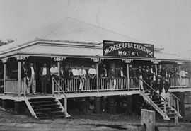
Mudgeeraba Exchange Hotel, 1915 | |||||||||||||
| Population | 13,204 (2011)[1] | ||||||||||||
| Postcode(s) | 4213 | ||||||||||||
| LGA(s) | Gold Coast City Council | ||||||||||||
| State electorate(s) | Mudgeeraba | ||||||||||||
| Federal Division(s) | McPherson, Wright | ||||||||||||
| |||||||||||||
Mudgeeraba is a suburb of Queensland, situated in the Gold Coast Hinterland. At the 2011 Australian Census the suburb recorded a population of 13,204.[1]
Geography
Mudgeeraba Creek is the major creek of a catchment area in the southern region of the Gold Coast. It is part of the larger catchment area of Nerang River. Bonogin and Wyangan Creeks are tributaries of Mudgeeraba Creek. Since 2005, under the Beaches to Bushland restoration program, Gold Coast City with the Austinville Landcare Group have worked on restoration of areas of upper Mudgerraba Creek.[2]
History

Mudgeeraba is remnant of the type of township that characterises the rural hinterland of the Gold Coast. Subdivision of land was conventional and buildings were traditionally rural or rural commercial. The Schmidt Farmhouse is typical of farms of that period in the district (the farmhouse is now in the adjacent suburb of Worongary).[3]


Mudgeeraba, like other areas, was an early centre, which rose to some prominence with the coming of the railway from Brisbane to Tweed Heads in 1903. The station of the South Coast railway line was located near the present-day motorway entrance.[4] The railway was closed in 1961. The modern day Pacific Motorway largely follows the route of the former railway. The new Gold Coast railway opened on a different alignment from Brisbane to neighbouring Robina in 1998. Robina station is about 1.8 km further than the old Mudgeeraba station.
In the early 1930s, the Upper Mudgeeraba Creek banks were location of unemployment relief camps set up under the Income (Unemployment Relief) Tax Acts, 1930. The creek water helped sustain vegetable gardens for the residents, housed in timber and corrugated iron huts.[5]
Contained on an 'island' within the flood plain, its essential character remains one of a nineteenth-century village despite the recent encroachment of housing estates to nearby land. Mudgeeraba contains important evidence of its earlier form and building and most older houses are situated on large blocks of 0.5 acres (2,000 m2) to 2 acres (8,100 m2).
Origin of the name
It is thought that the name was derived from an Indigenous Australian expression meaning, "place of infant's excrement", "place where someone told lies" or "place of sticky soil".[6] Another theory is that the name means "low-lying ground".[7][8]
Notable people
- d'Arcy Doyle, artist
- Darius Boyd, rugby league player for the Newcastle Knights
- Matthew Saunoa, 2006 New Zealand Idol champion
Schools
- Clover Hill State School
- Mudgeeraba Creek State School
- Mudgeeraba State School
- Mudgeeraba Special School
- Somerset College
Demographics
In the 2011 Census the population of Mudgeeraba is 13,204, 51.3% female and 48.7% male.
The median/average age of the Mudgeeraba population is 36 years of age, 1 year below the Australian average.
69% of people living in Mudgeeraba were born in Australia. The other top responses for country of birth were New Zealand 8.5%, England 6.1%, South Africa 1.7%, Scotland 0.7%, Germany 0.7%.
88.7% of people speak English as their first language 0.7% Japanese, 0.6% German, 0.6% Mandarin, 0.4% Cantonese, 0.4% Spanish.
Sport and recreation
A number of well-known sporting teams represent the area, including the Mudgeeraba Redbacks, the local rugby league club who play home games at Firth Park. There is also the Mudgeeraba Lawn Bowls Club situated just behind the Rugby Club and the Mudgeeraba Soccer Club.
References
- ↑ 1.0 1.1 Australian Bureau of Statistics (31 October 2012). "Mudgeeraba (State Suburb)". 2011 Census QuickStats. Retrieved 14 October 2013.
- ↑ "Bushcare and Landcare groups". The City of Gold Coast. Retrieved 30 November 2013.
- ↑ "Schmidt Farmhouse & Outbuildings (former) (entry 16625)". Queensland Heritage Register. Queensland Heritage Council. Retrieved 16 November 2014.
- ↑ "Mudgeeraba history". Gold Coast City Council. Retrieved 15 November 2014.
- ↑ "Mudgeeraba and Currumbin Creeks unemployment relief camps, 1931". Department of Labour and Industry. Retrieved 30 November 2013.
- ↑ Mudgeerabawikp History
- ↑ "SKETCHER.". The Queenslander (National Library of Australia). 11 April 1914. p. 8. Retrieved 18 September 2012.
- ↑ "ANSWERS.". The Brisbane Courier (National Library of Australia). 12 December 1931. p. 14. Retrieved 18 September 2012.
External links
| Wikimedia Commons has media related to Mudgeeraba, Queensland. |
- University of Queensland: Queensland Places: Mudgeeraba
- Mudgeeraba History
- Mudgeeraba Branch Library