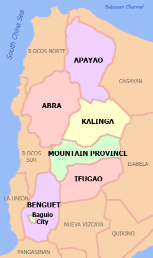
Mountain Province
| Mountain Province Lalawigang Bulubundukin | |||
|---|---|---|---|
| Province | |||
| |||
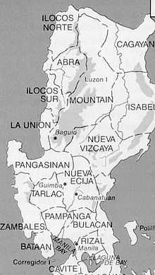
 Location in the Philippines | |||
| Coordinates: 17°05′N 121°10′E / 17.083°N 121.167°ECoordinates: 17°05′N 121°10′E / 17.083°N 121.167°E | |||
| Country | Philippines | ||
| Region | Cordillera Administrative Region (CAR) | ||
| Founded | 1908 | ||
| Capital | Bontoc | ||
| Government | |||
| • Governor | Leonard Mayaen (Independent) | ||
| • Vice Governor | Boni Lacwasan (Independent) | ||
| Area[1] | |||
| • Total | 2,157.38 km2 (832.97 sq mi) | ||
| Area rank | 58th out of 81 | ||
| Population (2010)[2] | |||
| • Total | 154,187 | ||
| • Rank | 76th out of 81 | ||
| • Density | 71/km2 (190/sq mi) | ||
| • Density rank | 75th out of 81 | ||
| Divisions | |||
| • Independent cities | 0 | ||
| • Component cities | 0 | ||
| • Municipalities | 10 | ||
| • Barangays | 144 | ||
| • Districts | Lone district of Mountain Province | ||
| Time zone | PHT (UTC+8) | ||
| ZIP code | 2616 to 2625 | ||
| Dialing code | 74 | ||
| ISO 3166 code | PH-MOU | ||
| Spoken languages | Ilocano, Bontoc, Kankana-ey, Pangasinan, Tagalog, English | ||
| Website |
mountainprovince | ||

Mountain Province (Filipino: Lalawigang Bulubundukin), is a landlocked province of the Philippines in the Cordillera Administrative Region in Luzon. Its capital is Bontoc.
Mountain Province is sometimes incorrectly named Mountain in some foreign references. The name is also incorrectly shortened by locals to Mt. Province, which in turn is read by native Anglophones as "Mount Province". The province was named so for being in the Cordillera Central mountain range found in the upper realms of Luzon island.
Mountain Province was also the name of the historical province that included most of the current Cordillera provinces. This old province was established by the Philippine Commission in 1908,[3][4][5] and was later split in 1966 into Mountain Province, Benguet, Kalinga-Apayao and Ifugao.[6] [7][8]
The province is also known for its mummy caves, which contain naturally mummified bodies, and for its hanging coffins.[6]
History
Spanish Period
The area of the Cordillera mountains proved difficult to control by the Spaniards. From 1566 to 1665, they sent expeditions to conquer the land but the rugged terrain and hostile indigenous population at the time were major obstacles to complete subjugation.[9]
Formerly called La Montañosa by the Spanish colonizers due to its mountainous terrain,[6][10] the area was subdivided into 6 comandancias politico-militar.[11]
| Comandancia | Year established | Comandancia | Year established |
|---|---|---|---|
| Benguet | 1846 | Amburayan | 1889 |
| Lepanto | 1852 | Kayapa | 1891 |
| Bontoc | 1859 | Cabugaoan | 1891 |
American Period
In August 19, 1908, during the American rule, the Philippine Commission enacted Act No. 1876, which organized the entire area of the Cordilleras into one large province, named Mountain Province.[3][5][6][12] The first governor was Samuel Cane, and the town of Bontoc was made the capital. It was originally composed of the sub-provinces of Amburayan, Apayao, Benguet, Lepanto-Bontoc, Ifugao and Kalinga.[10][5] Amburayan was later abolished in 1920 and its corresponding territories were transferred to the provinces of Ilocos Sur and La Union. Lepanto was also reduced in size and its towns were integrated into the sub-provinces of Bontoc and Benguet, and to the province of Ilocos Sur.[9][13] [14]
the province and its original boundaries
| Sub-province | Abolished? | Notes | Sub-province | Abolished? | Notes |
|---|---|---|---|---|---|
| Amburayan | Yes, in 1920 | Territories annexed to Ilocos Sur and La Union [5][14] | Ifugao | No | |
| Apayao | No | Kalinga | No | ||
| Benguet | No | Eastern towns annexed to Ilocos Sur and La Union in 1920[14] | Lepanto-Bontoc | Yes, in 1920 | Territories annexed to Ilocos Sur, Bontoc and Benguet[5][14] |
Post-war era
Effective on April 7, 1967, Republic Act No. 4695 abolished the old Mountain Province, converting its sub-provinces into 4 independent provinces: Benguet, Ifugao, Kalinga-Apayao and Mountain Province (corresponding to the former Bontoc sub-province).[6][10][8] On June 15, 1987, the Cordillera Administrative Region was established upon the issuance of Executive Order 220 by then-President Corazon Aquino, and Mountain Province was made one of its provinces.[9] [15][16]
Geography
Mountain Province is bounded in the east by Isabela, in the north by the provinces of Kalinga, Apayao, and Abra, in the south of Benguet and Ifugao, and in the west by the province of Ilocos Sur.
It has an area of 215,738 hectares (533,100 acres),[1] with 83% mountainous while 17% make up hills and levels. The province has many rivers, waterfalls, mountains, and caves. The central and western areas of the province are characterized by rugged mountains and steep cliffs, while the eastern portion has generally sloping terrain.[6][10]
Administrative
Mountain Province is subdivided into ten municipalities, all of which belong to a lone legislative district.[17]

| Seal | Municipality | Land area (km2)[17] |
Population (2010)[18] |
Pop. density (per km2) |
No. of barangays |
ZIP code | Income class[17] |
Location |
|---|---|---|---|---|---|---|---|---|
| |
||||||||
 | Barlig | 228.64 | 5,838 | 25.5 | 11 | 2623 | 5th | |
| Bauko | 153 | 30,172 | 197.2 | 22 | 2621 | 4th | | |
 | Besao | 173.62 | 7,818 | 45 | 14 | 2618 | 5th | |
 | Bontoc † | 396.1 | 23,980 | 60.5 | 16 | 2616 | 2nd | |
 | Natonin | 252 | 10,048 | 39.9 | 11 | 2624 | 4th | |
| Paracelis | 570.16 | 26,476 | 46.4 | 9 | 2625 | 2nd | | |
 | Sabangan | 72.04 | 8,741 | 121.3 | 15 | 2622 | 5th | |
 | Sadanga | 83.3 | 9,181 | 110.2 | 8 | 2617 | 5th | |
 | Sagada | 83.32 | 11,244 | 134.9 | 19 | 2619 | 5th | |
 | Tadian | 145.2 | 20,689 | 142.5 | 19 | 2620 | 4th | |
 | Mountain Province Total | 2157.38 | 154,187 | 71.5 | 144 | 2616 - 2625 | 4th[1] | |
Barangays
Mountain Province has 144 barangays comprising its 10 municipalities.[18]
As of 2010, the most populous barangay in the province is Poblacion in the municipality of Paracelis, with a total of 5,687 inhabitants. Balintaugan in the municipality of Bauko has the least population with only 144.[18]
Demographics
| Population census of Mountain Province | ||
|---|---|---|
| Year | Pop. | ±% p.a. |
| 1990 | 116,535 | — |
| 1995 | 130,755 | +2.18% |
| 2000 | 140,631 | +1.57% |
| 2007 | 148,661 | +0.77% |
| 2010 | 154,187 | +1.34% |
| Source: National Statistics Office[2][19] | ||
Based on the 2000 census survey, 52% of the population are Kankana-ey. Other ethnic groups living in the province are the Balangao 13.6%, Ibontoc 12%, and other ethnicity comprise about 21.6% of the province's population.[20]
Tourism

The province has several rice terraces in its different towns:[10]
- Kapayawan Rice Terraces - Bauko
- Bangen Rice Terraces - Bauko
- Besao Rice Terraces - Besao
- Bucas Rice Terraces - Besao
- Maligcong Rice Terraces - Bontoc
- Bayyo Rice Terraces - Bontoc
- Bontoc Poblacion Rice Terraces - Bontoc
- Dalican Rice Terraces - Bontoc
- Kiltepan Rice Terraces - Sagada
- Tanulong Rice Terraces - Sagada
- Suyo Rice Terraces - Sagada
- Bulongan Rice Terraces - Sagada
- Bangaan Rice Terraces - Sagada
- Ambasing Rice Terraces - Sagada
- Fidelisan Rice Terraces - Sagada
- Sadanga Rice Terraces - Sadanga
- Focong Rice Terraces - Sadanga
- Natonin Rice Terraces - Natonin
- Barlig Rice Terraces - Barlig
Opposite the rice terraces, the eastern side of low mountains and hills of Paracelis, boasts of rolling terrains of cornfields with good viewing decks on roadside.
Government
List of former governors:
- 2001–2004 Sario M. Malinias
- 2004–2010 Maximo B. Dalog
- 2010–2016 Leonard G. Mayaen
References
- ↑ 1.0 1.1 1.2 "List of Provinces". PSGC Interactive. Makati City, Philippines: National Statistical Coordination Board. Retrieved 23 December 2013.
- ↑ 2.0 2.1 "Total Population by Province, City, Municipality and Barangay: as of May 1, 2010" (PDF). 2010 Census of Population and Housing. National Statistics Office. Retrieved 23 December 2013.
- ↑ 3.0 3.1 3.2 Worcester, Dean C.; Philippine Commission (1908). Seventh Annual Report of the Secretary of the Interior to the Philippine Commission for the Fiscal Year Ended June 30, 1908. Manila: U.S. Government Printing Office. pp. 17–19. Archived from the original (DIGITIZED BY GOOGLE ON 23 NOV 2005 (ORIGINAL FILE FROM THE UNIVERSITY OF MICHIGAN)) on 23 Nov 2005. Retrieved 2 January 2015.
(Google Books link)
- ↑ Keesing, Felix Maxwell; Keesing, Marie Margaret; Keesing, Marie Martin; Institute of Pacific Relations (contributor); International Research Committee (contributor) (1934). Taming Philippine Headhunters: A Study of Government and of Cultural Change in Northern Luzon. Stanford University Press. p. 69. ISBN 9780804721103. Retrieved 2 January 2015.
- ↑ 5.0 5.1 5.2 5.3 5.4 5.5 Ingles, Raul Rafael (2008). 1908 :The Way it Really was : Historical Journal for the UP Centennial, 1908-2008. Diliman, Quezon City: University of the Philippines Press. p. 339. ISBN 9789715425803. Retrieved 22 October 2014.
- ↑ 6.0 6.1 6.2 6.3 6.4 6.5 Lancion, Jr., Conrado M.; de Guzman, Rey (cartography) (1995). "The Provinces". Fast Facts about Philippine Provinces (The 2000 Millenium ed.). Makati, Metro Manila: Tahanan Books. pp. 108–109. ISBN 971-630-037-9. Retrieved 16 January 2015.
- ↑ "Natural Attractions found in Atok". Province of Benguet. Retrieved 13 August 2013.
- ↑ 8.0 8.1 "Republic Act No. 4695: An Act Creating the Provinces of Benguet, Mountain Province, Ifugao and Kalinga-Apayao". Chan Robles Virtual Law Library. Retrieved 22 October 2014.
- ↑ 9.0 9.1 9.2 "Mt. Province". VisitMyPhilippines.com The Ultimate Travel Guide for Tourists. Department of Tourism. Retrieved 23 December 2013.
- ↑ 10.0 10.1 10.2 10.3 10.4 "Facts & Figures: Mountain Province". Philippine Statistics Authority - National Statistical Coordination Board - Cordillera Administrative Region. Retrieved 22 October 2014.
- ↑ 11.0 11.1 11.2 "Benguet History". Province of Benguet (official website). Retrieved 22 October 2014.
Benguet was once part of Mountain Province.
- ↑ "Act No. 1876". PhilippineLaw.info. 18 August 1908. Retrieved 22 October 2014.
- ↑ Philippines. Census Office; Buencamino, Felipe; Villamor, Ignacio (1920). Census of the Philippine Islands Taken Under the Direction of the Philippine Legislature in the Year 1918, Volume 1. Bureau of printing. p. 68.
- ↑ 14.0 14.1 14.2 14.3 14.4 "Cordillera Administrative Region History". Cordillera Connection (Blogspot). 14 August 2009. Retrieved 22 October 2014.
- ↑ "Regional Profile: Cordillera Administrative Region (CAR)". CountrySTAT Philippines. Retrieved 22 October 2014.
- ↑ "The Cordillera Administrative Region (CAR)". Department of Agriculture. Retrieved 22 October 2014.
- ↑ 17.0 17.1 17.2 "Province: Mountain Province". Philippine Statistics Authority - National Statistical Coordination Board. Retrieved 20 February 2015.
- ↑ 18.0 18.1 18.2 "2010 Census of Population and Housing: Population Counts - Cordillera Administrative Region" (PDF). National Statistics Office (Philippines), April 4, 2012. Retrieved 16 November 2014.
- ↑ "Population and Annual Growth Rates for The Philippines and Its Regions, Provinces, and Highly Urbanized Cities" (PDF). 2010 Census and Housing Population. National Statistics Office. Retrieved 26 August 2013.
- ↑ http://www.census.gov.ph/data/pressrelease/2002/pr0212tx.html
External links
| Wikimedia Commons has media related to Mountain Province. |
 |
Abra | Kalinga | | |
| Ilocos Sur | |
Isabela | ||
| ||||
| | ||||
| Benguet | Ifugao |
| ||||||||||||||
| ||||||||||||||||||||||||||||||||||

