Mount Wilhelm
| Mount Wilhelm | |
|---|---|
| Enduwa Kombuglu | |
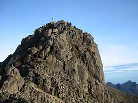 The granite peak of Mount Wilhelm | |
| Elevation | 4,509 m (14,793 ft) |
| Prominence |
2,969 m (9,741 ft)[1] Ranked 107th |
| Listing |
Country high point Ultra |
| Location | |
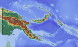 Mount Wilhelm Location of Mount Wilhelm in Papua New Guinea | |
| Location | Intersection of Simbu, Western Highlands and Madang provinces in Papua New Guinea |
| Range | Bismarck Range |
| Coordinates | 05°48′S 145°02′E / 5.800°S 145.033°ECoordinates: 05°48′S 145°02′E / 5.800°S 145.033°E |
| Climbing | |
| First ascent | 15 August 1938 by Leigh Vial |
| Easiest route | Rock scramble |
Mount Wilhelm (German: Wilhelmsberg), 4,509 metres (14,793 ft), is the highest mountain in Papua New Guinea. It is part of the Bismarck Range and the peak is the point where three provinces, Simbu, Western Highlands and Madang, meet. The peak is also known as Enduwa Kombuglu in the local Kuman language, a Papuan language.[2]
The mountain is on the island of New Guinea, which incorporates Papua New Guinea and the Indonesian province of Papua. It is surpassed by Puncak Jaya, 4,884 m (16,024 ft), and several other peaks in Indonesian Papua.
Some sources claim Mount Wilhelm as the highest mountain in Oceania or Australia, on account of Indonesia being part of Asia.[3] A Seven Summits list sometimes includes Mount Wilhelm.
History
Discovery
Mount Wilhelm received its name in 1888 when a German newspaper correspondent, Hugo Zöller, climbed the Finisterre Range, south-east of Madang, and named the Bismarck Range after the German Chancellor, Otto von Bismarck, and the four highest peaks of the range after him and his children: Ottoberg, Herbert-berg, Marienberg and Wilhelm-berg.[4] Otto-berg seemed to Zöller to be the highest of the range, but it was later discovered to be only 11,600 feet (3,540 m) and the distant Wilhelmberg was much taller.[5]
It was not until August 1938 when Leigh Vial, a government patrol officer, and two Papuan New Guineans made the first recorded ascent.[4] It was noted by Vial that even though the mountain was close to the equator, snow existed on top of the mountain at the time of ascent.[6]

WWII bomber crash
During the Second World War in the early hours of May 22, 1944, an American F-7A (a converted B-24 Liberator) named "Under Exposed" crashed into the mountain while flying too low. The aircraft left from Nadzab airbase, close to Lae, and had been assigned for a reconnaissance mission to photograph Padaidori Island in Dutch New Guinea. Around 0400 the plane crashed into Wilhelm at about 13,000 feet (4,000 m) above the twin lakes.[7] All crew were killed and most of the wreckage landed in the topmost lake although some can still be seen today. The only remains at the site are from the plane, as all bodies have been recovered.
Climbing deaths
A number of people have died trying to climb the mountain. An Australian Army Sergeant, Christopher Donnan, died in December 1971 when he fell down a steep slope. There is a plaque at the point where he was last seen. In August 1995 an Israeli backpacker died after he sprained his ankle and stayed behind while his group continued. He subsequently wandered off the track and fell into a ravine in the pre-dawn darkness. His body was found about a week later.[8] On 30 July 2005 58-year-old Bob Martin, a marketing manager at Air Niugini, suffered a heart attack and died near the summit.[9][10]
Ascending


Mount Wilhelm is the most accessible mountain to climb in Papua New Guinea. There are two routes to the top. The most common route starts from the village of Keglsugl at the end of the road from Kundiawa in Simbu province. A harder hike and climb starts from the village of Ambullua in the Western Highlands province.
The Keglsugl route involves climbing up and through a mountain rain forest and then along an alpine grassland glacial valley to the twin lakes of Piunde and Aunde. At Piunde there are two huts, one being an old Australian National University monitoring station and the other an 'A-Frame' hut. Though not a technical climb, various sections can be treacherous in wet weather. The climb is usually started during the night; the ascent and subsequent descent can take anywhere from nine to 24 hours. Reaching the peak at dawn allows a better chance of clear weather.
The other route from Ambullua is a much harder 4-day hike.
See also
References
- ↑ This prominence is from Papua New Guinea ultra-prominent peaks on peaklist.org. The prominence is sometimes given as 2,949 metres (9,675 ft) or 2,922 m (9,587 ft).
- ↑ Nolan, Riall W. (1983). Bushwalking in Papua New Guinea (1 ed.). Lonely Planet. ISBN 0-908086-41-5.
- ↑ Statistical Yearbook of Croatia, 2007
- ↑ 4.0 4.1 Pérusse, Yvon (July 1993). Bushwalking in Papua New Guinea (2 ed.). Lonely Planet. p. 156. ISBN 0-86442-052-8.
- ↑ Souter, Gavin (1963). New Guinea: The Last Unknown. Angus & Robertson. p. 76. ISBN 0-207-94627-2.
- ↑ Vial, L.G. (May 1939). "The Kamans". Walkabout.
- ↑ "F7-A "Under Exposed" Serial Number 42-73052". Pacific Wreck Database. Retrieved 2007-01-16.
- ↑ Adrian Lipscomb; Rowan McKinnon; Jon Murray. Papua New Guinea (6 ed.). Lonely Planet. p. 231. ISBN 0-86442-402-7.
- ↑ "PNG Loses Great Tourism Ambassador". Papua New Guinea Business and Tourism Forum. Retrieved 2007-01-15.
- ↑ TPA Monthly Newsletter Update ISSUE 17 - July - August 2005
External links
| Wikimedia Commons has media related to Mount Wilhelm. |
| ||||||||
| ||||||||||||||||||||||||||||||||||