Mount Wellington, New Zealand
| Mount Wellington | |
|---|---|
 | |
| Basic information | |
| Local authority | Auckland |
| Facilities | |
| Train station(s) | Panmure Train Station |
| Surrounds | |
| North | Ellerslie, St. John's Park |
| East | Tamaki River, Pakuranga |
| South | Westfield |
| West | Penrose |
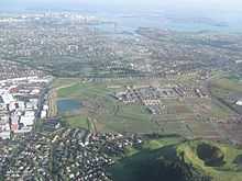
Mount Wellington is a suburb in East Auckland, New Zealand.
The suburb
The suburb surrounding the peak is also called Mount Wellington, and is located 10 kilometres southeast of the city centre. It is surrounded by the suburbs of Stonefields, Tamaki, Panmure, Penrose, and Ellerslie, and by the Tamaki River. State secondary schools serving the area include St Peter's College and Selwyn College.
Maungarei
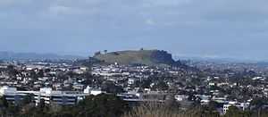
Maungarei / Mount Wellington is a 135 metre [1] volcanic peak located in the Auckland volcanic field of Auckland, New Zealand. It is the youngest onshore volcano of the Auckland volcanic field, having been formed by an eruption around 10,000 years ago. It is the largest of Auckland's scoria cones.[2] Maungarei / Mount Wellington is not expected to erupt again.
Education
- Bailey Road School is a state, coeducational full primary (years 1-8) school with a roll of 418 and a decile rating of 3.[3]
- Stanhope Road School is a state, coeducational full primary (years 1-8) school with a roll of 495 and a decile rating of 4. It was established in 1958.[4]
- Sylvia Park School is a state, coeducational full primary (years 1-8) school with a roll of 248 and a decile rating of 2.[5]
See also
References
- ↑ http://www.arc.govt.nz/environment/volcanoes-of-auckland/mt-wellington.cfm
- ↑ "Volcanoes of Auckland: Mt Wellington". Auckland Regional Council. Retrieved 2009-03-05.
- ↑ Te Kete Ipurangi schools database: Bailey Road School
- ↑ Te Kete Ipurangi schools database: Stanhope Road School
- ↑ Te Kete Ipurangi schools database: Sylvia Park School
- Volcanoes of Auckland: The Essential guide - Hayward, B.W., Murdoch, G., Maitland, G.; Auckland University Press, 2011.
External links
Coordinates: 36°53′31″S 174°50′48″E / 36.891909°S 174.846554°E