Mount Vsevidof
| Mount Vsevidof | |
|---|---|
 View, looking north, of Mount Vsevidof | |
| Elevation | 7,051 ft (2,149 m) |
| Prominence | 7,051 ft (2,149 m) |
| Listing | Ultra |
| Location | |
 Mount Vsevidof Alaska | |
| Location | Umnak Island, Alaska, U.S. |
| Range | Aleutian Range |
| Coordinates | 53°07′48″N 168°41′34.8″W / 53.13000°N 168.693000°WCoordinates: 53°07′48″N 168°41′34.8″W / 53.13000°N 168.693000°W |
| Geology | |
| Type | Stratovolcano |
| Volcanic arc/belt | Aleutian Arc |
| Last eruption | 1878 |
Mount Vsevidof (/ˌvɪzəˈviːdɒf/[1] or /vəˈʃeɪvɨdɒf/)[2] is a stratovolcano in the U.S. state of Alaska. Its summit is the highest point on Umnak Island, one of the eastern Aleutian Islands. Its symmetrical cone rises abruptly from its surroundings. Its most recent eruption was caused by an earthquake on March 9, 1957. The mountain erupted on March 11, 1957, and the eruption ended the next day.[3]
Its name comes from Russian and means "is seen from everywhere".
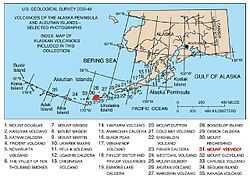
Map showing volcanoes of Alaska. The mark is set at the location of Mount Vsevidof.
See also
References
- ↑ Luke Smith, "The Lodge at the Edge of the World," Alaska magazine, February 2007.
- ↑ AllRefer.com
- ↑ This is recorded as a "questionable eruption" by the Alaska Volcano Observatory (Vsevidof History Page). Other possible eruptions or other activity occurred in 1784, 1790, 1830, 1878, and 1880.