Mount Victoria, Maryland
| Mount Victoria, Maryland | |
|---|---|
| Unincorporated community | |
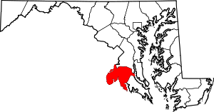
 Mount Victoria Location within the state of Maryland | |
| Coordinates: 38°21′12″N 76°53′45″W / 38.35333°N 76.89583°WCoordinates: 38°21′12″N 76°53′45″W / 38.35333°N 76.89583°W | |
| Country | United States |
| State | Maryland |
| County | Charles |
| Time zone | Eastern (EST) (UTC-5) |
| • Summer (DST) | EDT (UTC-4) |
| GNIS feature ID | 590846 |
Mount Victoria is an unincorporated community in southern Charles County, Maryland, United States, between the Wicomico and Potomac Rivers.[1] It was named for an enormous farm of 15,000 acres (61 km2) owned by Robert Crain, an attorney and farmer whose lobbying efforts led to the opening in 1927 of the Maryland portion of U.S. Highway 301. This farm was said at the time to be the largest private landholding in Maryland.
References
| |||||||||||||||||||||