Mount Tallac
| Mount Tallac | |
|---|---|
 | |
| Elevation | 9,739 ft (2,968 m) NAVD 88[1] |
| Prominence | 695 ft (212 m)[2] |
| Listing |
Tahoe OGUL Peak List[3] Sierra Peaks Section[4] |
| Location | |
| Location | El Dorado County, California, U.S. |
| Range | Sierra Nevada |
| Coordinates | 38°54′22″N 120°05′56″W / 38.905984014°N 120.098975258°WCoordinates: 38°54′22″N 120°05′56″W / 38.905984014°N 120.098975258°W[1] |
| Topo map | USGS Emerald Bay |
| Climbing | |
| Easiest route | Trail hike, class 1-2[5] |
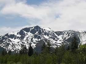
Mount Tallac is a mountain peak southwest of Lake Tahoe, in El Dorado County, California. The peak lies within the Desolation Wilderness in the Eldorado National Forest. It is quite visible from State Routes 89 and 28, and U.S. Route 50. A "cross of snow" is clearly visible on the mountain's face during the winter, spring, and early summer months.
Of the several trails leading to the summit, the Mount Tallac trailhead is the most frequented. This 5-mile (8 km) one-way trail, with an elevation gain of 3,250 feet (990 m), is given a difficulty rating of "intermediate to difficult" by the United States Forest Service.[5] The trail takes hikers past Floating Island Lake and Cathedral Lake on their way to the summit. On the southern side, next to Lilly Lake, is Glen Alpine trailhead. While providing a slightly longer route to the summit, (5.7 miles (9 km)), this trail brings hikers to Gilmore Lake. At approximately 8,300 feet (2,530 m), this lake is only 1,400 feet (427 m) below Tallac's summit. From the barren peak, nearly the entire Lake Tahoe basin can be seen.
The mountain is shown on maps of the Whitney Survey as Chrystal Peak. In 1877, the Wheeler Survey named the peak "Tallac", after the Washo word "daláʔak", meaning 'mountain'.[6]
References
- ↑ 1.0 1.1 "Tallac Peak 1893". NGS data sheet. U.S. National Geodetic Survey. Retrieved 2009-01-24.
- ↑ "Mount Tallac, California". Peakbagger.com. Retrieved 2009-01-24.
- ↑ "Tahoe OGUL Peak List". Western State Climbers. Retrieved 2014-01-19.
- ↑ "Sierra Peaks Section List". Angeles Chapter, Sierra Club. Retrieved 2014-01-19.
- ↑ 5.0 5.1 "East Side Trailheads and Trails". Eldorado National Forest. Retrieved 2014-01-19.
- ↑ Gudde, Erwin G. (1949). California Place Names. Berkeley: Univ. of California Press. pp. 352–353.
External links
- "Mount Tallac". Geographic Names Information System. United States Geological Survey.
- "Mount Tallac". SummitPost.org.