Mount Sterling, Alabama
| Mount Sterling, Alabama | |
|---|---|
| Unincorporated community | |
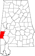
 Mount Sterling, Alabama Location within the state of Alabama | |
| Coordinates: 32°5′37″N 88°9′47″W / 32.09361°N 88.16306°W | |
| Country | United States |
| State | Alabama |
| County | Choctaw |
| Elevation | 164 ft (50 m) |
| Time zone | Central (CST) (UTC-6) |
| • Summer (DST) | CDT (UTC-5) |
| Area code(s) | 205 |
Mount Sterling is an unincorporated community in Choctaw County, Alabama.[1] Mount Sterling was once a prosperous antebellum community, with an economy based on cotton and timber, but today little is left other than a few scattered houses. One church building, the Mount Sterling Methodist Church, is listed on the National Register of Historic Places.[2][3]
Geography
Mount Sterling is located at 32°05′38″N 88°09′47″W / 32.09375°N 88.16307°WCoordinates: 32°05′38″N 88°09′47″W / 32.09375°N 88.16307°W and has an elevation of 164 feet (50 m).[1]
References
- ↑ 1.0 1.1 U.S. Geological Survey Geographic Names Information System: Mount Sterling, Alabama
- ↑ Chiat, Marilyn Joyce Segal (1997). America's Religious Architecture: Sacred Places For Every Community. John Wiley and Sons. p. 279. ISBN 978-0-471-14502-8.
- ↑ "National Register Information System". National Register of Historic Places. National Park Service. 2009-03-13.
| |||||||||||||||||||||||||