Mount San Cristobal
| Mount San Cristobal | |
|---|---|
| Mount Cristobal | |
 Mount San Cristobal | |
| Elevation | 1,470 m (4,820 ft)[1] |
| Location | |
.svg.png) Mount San Cristobal Location in the Philippines Quezon | |
| Location | Provinces of Quezon and Laguna on Luzon Island, Philippines. |
| Coordinates | 14°03′52″N 121°25′36″E / 14.06443°N 121.42680°ECoordinates: 14°03′52″N 121°25′36″E / 14.06443°N 121.42680°E |
| Geology | |
| Type | Complex volcano |
| Volcanic arc/belt | Macolod Corridor |
| Last eruption | Unknown |
| Climbing | |
| Easiest route | from Dolores, Quezon |
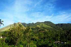
Mount San Cristobal is a dormant volcano in Quezon province on the island of Luzon, Philippines. The mountain rises to an elevation of 1,470 m (4,820 ft) above mean sea level [1] and is one of the volcanic features of Macolod Corridor.[2]
Mount San Cristobal is considered the Devil's mountain in Filipino folklore. It is the alter-ego of the Holy Mountain,[1] Mount Banahaw, and is part of Mount Banahaw-San Cristobal Protected Landscape covering 10,901 hectares (26,940 acres) of land.
The mountain is bounded by San Pablo City, province of Laguna at its northern slope and Dolores, province of Quezon at its southern slope.
Down to its northwestern slope is Tayak Hill, a hill at an elevation of 660 m (2,170 ft), which is a religious site commonly used by devoted Catholics as a vigil area.[3]
Mount San Cristobal is the western dome of the Banahaw Complex Volcano and is noted for having three peaks on its summit and has its own crater at 1,400 m (4,600 ft) which is now a swamp and a mossy forest.[3]
History
Tayak Hill, which is at the northwestern slope of Mount San Cristobal rising at 660 meters above sea level, was once used as a military supplies drop-off point during World War II. Now used as a vigil site for Catholic devotees; where a cross has been mounted on top.[3]
Hiking activity
Mount San Cristobal's main jump-off point is at Barangay Langka of Dolores, Quezon and is considered as the shortest route to the summit.
The hike features a 5-kilometer trail passing through abundant mossy forest. The summit however is not a famous destination as it is forested and the view is being blocked by the higher Mount Banahaw neighbor.
The most common destination is the clearing just passed its saddle campsite facing San Pablo City which gives a magnificent view of the Seven Lakes of San Pablo and neighboring mountains such as Malepunyo Range, Mount Makiling, and the mountains of Atimbia and Nagcarlan (Kalisungan).[3]
The trail coming from Rizal, Laguna at its northern slope is longer (9 kilometers) and is usually trekked as a traverse trail. This trail passes by the vicinity of Tayak Hill.
See also
References
- ↑ 1.0 1.1 1.2 "Mt. Cristobal (1,470+)". Pinoy Mountaineer. 23 September 2007. Retrieved 5 February 2015.
- ↑ Tectonophysics. Amsterdam: Elsevier Science Publishers. 1990. p. 266.
- ↑ 3.0 3.1 3.2 3.3 "Conquering Mt. Cristobal 1470+ MASL". Schadow1 Expeditions. 19 February 2013. Retrieved 5 February 2015.
External links
| Wikimedia Commons has media related to Mount San Cristobal. |