Mount Robie Reid
| Mount Robie Reid | |
|---|---|
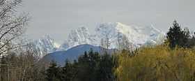 Mount Robie Reid from Langley | |
| Elevation | 2,095 m (6,873 ft)[1] |
| Prominence | 1,253 m (4,111 ft)[1] |
| Location | |
 Mount Robie Reid | |
| Range | Garibaldi Ranges |
| Coordinates | 49°25′55″N 122°21′22″W / 49.43194°N 122.35611°WCoordinates: 49°25′55″N 122°21′22″W / 49.43194°N 122.35611°W[2] |
| Topo map | NTS 092G08 |
Mount Robie Reid 2,095 m (6,873 ft) is a mountain in the southern end of the Garibaldi Ranges overlooking the Lower Mainland region of British Columbia, Canada. It lies to the north of Mission, British Columbia, Canada and on the west side of the upper end of Stave Lake, and to the northeast of the group of summits known as the Golden Ears. It has a prominence of 1,245 m (4,085 ft) relative to the lowest col between the valleys of Tingle and Osprey Creeks (Osprey Creek is tributary to the Pitt River drainage).
Together with Mount Judge Howay, which lies northeast across the deep valley of Tingle Creek, it was known as one of the Snow Peaks, and until its renaming in 1944 was referred to by old-timers as Old Baldy. Its name commemorates Robie Lewis Reid, a noted historian and educator whose colleague Frederic W. Howay is commemorated by Mount Judge Howay. Although relatively low, views of it dominate the mountain skyline from western Abbotsford and is also visible from Maple Ridge, North Surrey and New Westminster-Coquitlam, though from most of Mission it is invisible due to intervening smaller mountains and hill country.
References
- ↑ 1.0 1.1 "Mount Robie Reid". Bivouac.com. Retrieved 2010-03-21.
- ↑ "Mount Robie Reid". BC Geographical Names. Retrieved 2010-03-21.
External links
| Wikimedia Commons has media related to Mount Robie Reid. |