Mount Rat, South Australia
| Mount Rat South Australia | |
|---|---|
|
St Raphael's Anglican church | |
 Mount Rat | |
| Coordinates | 34°38′0″S 137°35′0″E / 34.63333°S 137.58333°ECoordinates: 34°38′0″S 137°35′0″E / 34.63333°S 137.58333°E |
| Established | 1850s |
| Elevation | 134 m (440 ft) |
| LGA(s) | Yorke Peninsula Council |
| State electorate(s) | Goyder |
| Federal Division(s) | Wakefield |
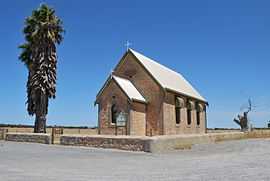
Mount Rat is a town in the Yorke Peninsula in South Australia. It is halfway between Maitland and Minlaton, South Australia. It was first founded in the 1850s, and by 1882 had a school, hotel, blacksmiths, chapel and a large water tank. By 1905 the school had closed, and now the town has mostly disappeared. There are two water tanks and a telecommunications tower at Mt Rat[1]
-
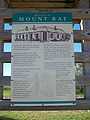
A close-up of the information sign.
References
- ↑ The sign (as per image above)
| Wikimedia Commons has media related to Mount Rat, South Australia. |
| ||||||||||||||||||||||||||||||||||||||||||||||||||