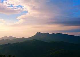
Mount Pico de Loro
| Mount Pico de Loro | |
|---|---|
| Mount Palay-Palay | |
 Mount Pico de Loro | |
| Elevation | 664 m (2,178 ft)[1] |
| Location | |
.svg.png) Mount Pico de Loro Location in the Philippines Cavite / Batangas | |
| Location | Mounts Palay-Palay–Mataas-na-Gulod Protected Landscape, Maragondon, Cavite and Nasugbu, Batangas, Luzon. |
| Coordinates | 14°12′51″N 120°38′47″E / 14.21427°N 120.64645°ECoordinates: 14°12′51″N 120°38′47″E / 14.21427°N 120.64645°E |
| Geology | |
| Type | Stratovolcano |
| Volcanic arc/belt | Bataan Arc |
| Last eruption | Unknown |
| Climbing | |
| Easiest route | from Ternate, Cavite |
Mount Pico de Loro, also known as Mount Palay-Palay, is a dormant volcano in Cavite province on the island of Luzon, Philippines. The mountain rises to an elevation of 664 m (2,178 ft) above mean sea level [1] and is one of the ancient volcanic features of Bataan Arc.[2]
Mount Pico de Loro is the most notable mountain at Mounts Palay-Palay–Mataas-na-Gulod Protected Landscape and is considered as one of the two prominent mountains of the protected landscape together with Mount Marami. It features a monolith or a natural 60-meter rock column beside its summit which is the major attraction of the mountain.
Although the major jump-off of the mountain is at Ternate, most of its area is under Maragondon. Its summit is shared among the boundary of both the province of Cavite and Batangas.
History
Pico de Loro was first named by Spanish sea-farers which means "Parrot's Beak" as its pointed summit resembles the shape of a parrot's beak from afar and it is commonly used as a signal by sea-farers to turn east to get to Manila Bay [3]
Governance
Under the Proclamation No. 1315 s.2007 [4] of the Philippine government, the Mounts Palay-Palay–Mataas-na-Gulod Protected Landscape is placed under the protection and jurisdiction of the Department of Environment and Natural Resources. However, a local, Rey Medina, who has been living within the mountain has claimed he has developed and maintained the trail to Pico de Loro summit and has been managing its base camp over the years. Thus fees have been collected both by DENR and Mr. Medina.[1]
Hiking activity

Mt. Pico de Loro is most frequented mountain of the Mounts Palay-Palay–Mataas-na-Gulod Protected Landscape, together with Mount Marami. There are two major jump-off to the mountain. One is via Ternate which is usually is the primary jump-off to the mountain and the other is at the border of Maragondon and Nasugbu at Barangay Papaya, which is usually the traverse exit point.
The hike to the summit features a 5-kilometer long trail passing through forested areas and minor streams. The saddle camp beside the summit is notable for its bamboo trees while the summit itself is grass.
A side trip to Pico de Loro Waterfalls is also notable especially during rainy season.
Its summit gives a spectacular 360-degree view to the whole protected landscape. To its north is Manila Bay and Corregidor, and to the south are the remaining portions of the protected landscape which includes Mataas na Gulod, and Dos Picos as well as the far mountains of Nasugbu such as Mount Talamitam and Batulao. To the west is the Limbones Cove and the rest of the West Philippine Sea.
An adjacent 60-meter rock column from the summit is the Monolith which rock climbers scale to get another exhilarating view.
Last December 20, 2014, the first mapping expedition was held by a five-man team organized by Schadow1 Expeditions and led by Ervin Malicdem, that documented a trail from Mount Marami to Mt. Pico de Loro, injecting through the dense jungle of the Mounts Palay-Palay–Mataas-na-Gulod Protected Landscape.[5]
Transportation
Last July 1, 2013, the Kaybiang Tunnel, the country's longest underground highway tunnel at 300 meters was opened along the Ternate-Nasugbu Road piercing through Mt. Pico de Loro's north ridge, that shortens the travel time from Manila to the western coves of Cavite and Nasugbu, Batangas.[6]
See also
References
- ↑ 1.0 1.1 1.2 "Conquering Pico De Loro 664+MASL". Schadow1 Expeditions. Retrieved 17 January 2015.
- ↑ Tectonophysics. Amsterdam: Elsevier Science Publishers. 1990. p. 266.
- ↑ "Pico De Loro (664+)". Pinoy Mountaineer. Retrieved 17 January 2015.
- ↑ "Proclamation No. 1315, s. 2007". Official Gazette of the Republic of the Philippines. Retrieved 17 January 2015.
- ↑ "Mataas na Gulod - Palay-Palay Mountain Range Mapping Expedition (Marami to Pico De Loro Traverse)". Schadow1 Expeditions. 22 December 2014. Retrieved 17 January 2015.
- ↑ "Kaybiang Tunnel - The Gateway to the Western Coves of Cavite and Batangas". Schadow1 Expeditions. 28 July 2013. Retrieved 30 July 2013.
External links
| Wikimedia Commons has media related to Mount Pico De Loro. |