Mount Marapi
| Marapi | |
|---|---|
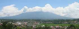 Marapi in 2005 | |
| Elevation | 2,891 m (9,485 ft)[1] |
| Prominence | 2,116 m (6,942 ft) |
| Listing |
Ultra Ribu |
| Location | |
 Marapi | |
| Range | Barisan Mountains |
| Coordinates | 00°22′51.59″S 100°28′22.79″E / 0.3809972°S 100.4729972°ECoordinates: 00°22′51.59″S 100°28′22.79″E / 0.3809972°S 100.4729972°E[1] |
| Geology | |
| Type | Complex volcano |
| Last eruption | February 2014 |
Marapi (also known as Merapi or Berapi) is a complex volcano in West Sumatra, Indonesia. Its name means Mountain of Fire, and it is the most active volcano in Sumatra. Its elevation is 2,891.3 metres (9,485.9 ft). A number of cities and towns are situated around the mountain, including Bukittinggi, Padang Panjang and Batusangkar.
According to legend, the mountain is the site first settled by the Minangkabau people after their ship landed on the mountain when it was the size of an egg and surrounded by water.[2] There are large numbers of upright burial stones in the region which are oriented in the direction of the mountain, indicating its cultural significance.[3]
Since August 3, 2011 Alert Level has been established by Center of Vulcanology and Mitigation Geology Disaster.[4]
See also
References
- ↑ 1.0 1.1 "Marapi". Global Volcanism Program. Smithsonian Institution. Retrieved 2013-12-24.
- ↑ Summerfield, Anne; Summerfield, John (1999). Walk in Splendor: Ceremonial Dress and the Minangkabau. UCLA. ISBN 0-930741-73-0.
- ↑ Miksic, John (2004). "From megaliths to tombstones: the transition from pre-history to early Islamic period in highland West Sumatra.". Indonesia and the Malay World 32 (93): 191. doi:10.1080/1363981042000320134.
- ↑ "Februari, Marapi Meletus 41 Kali". Padang Ekspres. February 20, 2012. Retrieved 2013-12-24.
External links
- "Marapi". Global Volcanism Program. Smithsonian Institution.
- Indonesian Directorate of Volcanology and Geological Hazard Mitigation entry