Mount Jerai
| Mount Jerai | |
|---|---|
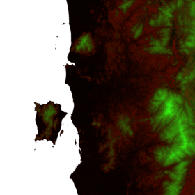 Mount Jerai is the isolated greenish triangle at the upper middle of this heightmap | |
| Elevation | 1,217 m (3,993 ft) |
| Location | |
| Location | Kedah, Malaysia |
| Range | Titiwangsa Mountains |
| Climbing | |
| First ascent | Hindu settlers about 800 AD |

1818 aquatint of distant Mount Jerai viewed from Penang Island
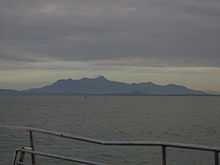
Mount Jerai (Malay: Gunung Jerai;) or formerly Kedah Peak is located in the Malaysian state of Kedah with the height of 3,854 feet (1,175 m). Within Kedah itself, the mountain stands at the border of Kuala Muda and Yan districts. The mountain is a massive limestone outcrop and is a lone feature from the surrounding geography of the area. There is an information board on top of the mountain stating that it used to be an island called Pulai Serai before the sea levels receded letting it form a mountain, but this fact has no research or historical basis.
The height of Mount Jerai relative to its surroundings allowed Indian traders and seafarers to use the mountain as a navigational point more than 1500 years ago. The mountain was considered sacred by the ancient Malays so they built temples from the foothills up to the summit. Hindu-Buddhist priests would pray at these stupas for the safety of Bujang Valley, the richest archaeological site in Malaysia located on the southern reaches of the mountain.
See also
| ||||||||||||||||||||||||||||||||
Coordinates: 5°47′N 100°26′E / 5.783°N 100.433°E