Mount Gould (Montana)
| Mount Gould | |
|---|---|
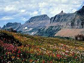 Mount Gould (center) and the rest of the Garden Wall | |
| Elevation | 9,553 ft (2,912 m)[1] |
| Prominence | 1,953 ft (595 m)[1] |
| Parent peak | Mount Siyeh |
| Listing | Mountains in Glacier County, Montana |
| Location | |
 Mount Gould | |
| Range | Lewis Range |
| Coordinates | 48°44′34″N 113°42′52″W / 48.74278°N 113.71444°WCoordinates: 48°44′34″N 113°42′52″W / 48.74278°N 113.71444°W[2] |
| Topo map | USGS Logan Pass |
| Climbing | |
| First ascent | 1920 by Frank B. Wynn, Harry R. Horn, Henry H. Goddard, and party |
| Easiest route | West Face (scramble/Class 3) |
Mount Gould is a peak on the Continental Divide in Glacier National Park, Montana, United States. It is the highest point of the Garden Wall, a distinctive ridge of the Lewis Range. It is most notable for its huge, steep east face, which drops 4,000 ft (1,220 m) in only one-half mile (0.8 km). This face provides a backdrop to Grinnell Lake, and is often photographed.
The first recorded[3] ascent of Mount Gould was in 1920, by Frank B. Wynn, Harry R. Horn, Henry H. Goddard, and party. They used the West Face route, which is the easiest and most commonly used route today. It starts from the Highline Trail, which skirts the west side of the peak, and involves some rock scrambling but no technical climbing.
Climbing the sheer East Face of Mount Gould is theoretically possible; however the brittle, loose nature of the rock in Glacier National Park makes the ascent highly technical, unpleasant, and dangerous.

See also
Notes
- ↑ 1.0 1.1 "Mount Gould, Montana". Peakbagger.com. Retrieved 2014-04-13.
- ↑ "Mount Gould". Geographic Names Information System. United States Geological Survey. Retrieved 2014-04-13.
- ↑ Since access to the summit is nontechnical, an earlier ascent, and perhaps a much earlier Native American ascent, is possible.
Source
- J. Gordon Edwards and Josephine Gould, A Climber's Guide to Glacier National Park, Falcon Press, 1991. ISBN 0-87842-177-7.
External links
| Wikimedia Commons has media related to Mount Gould (Montana). |