Mount Elgon
| Mount Elgon | |
|---|---|
| Wagagai (summit) | |
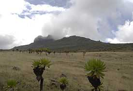
 Mount Elgon (left) and Great Rift Valley (right) | |
| Elevation |
4,321 m (14,177 ft)[1] Ranked 17th in Africa |
| Prominence | 2,458 m (8,064 ft)[1] |
| Listing | Ultra |
| Location | |
 Mount Elgon | |
| Coordinates | 01°07′06″N 34°31′30″E / 1.11833°N 34.52500°ECoordinates: 01°07′06″N 34°31′30″E / 1.11833°N 34.52500°E[1] |
| Topo map | Mount Elgon Map and Guide[2] |
| Geology | |
| Type | Shield volcano |
| Age of rock | Miocene origin |
| Last eruption | Unknown |
| Climbing | |
| First ascent | 1911 by Kmunke and Stigler |
| Easiest route | Scramble |

- See also Mount Elgon District
Mount Elgon is an extinct shield volcano on the border of Uganda and Kenya,[3] north of Kisumu and west of Kitale. The mountain's highest point, named "Wagagai", is located entirely within the country of Uganda.[4][1] At 4,321 m (14,177 ft), Elgon is the 17th-highest mountain of Africa.
Physical features
It is the oldest and largest solitary volcano in East Africa, covering an area around 3500 km2.
Other features of note are:
- The caldera — Elgon's is one of the largest intact calderas in the world.
- The warm springs by the Suam River
- Endebess Bluff (2563 m or 8408 ft)
- Ngwarisha, Makingeny, Chepnyalil, and Kitum caves: Kitum Cave is over 60 m wide and penetrates 200 m. The cave contains salt deposits and it is frequented by wild elephants that lick the salt exposed by gouging the walls with their tusks.[5] It became notorious following the publication of Richard Preston's book The Hot Zone in 1994 for its association with the Marburg virus after two people who had visited the cave (one in 1980 and another in 1987) contracted the disease and died.[6]
The mountain soils are red laterite. The mountain is the catchment area for the several rivers such as the Suam River, which becomes the Turkwel downstream and which drains into Lake Turkana, the Nzoia River and the Lwakhakha River which flow to Lake Victoria. The town of Kitale is in the foothills of the mountain. The area around the mountain is protected by two Mount Elgon National Parks, one on each side of the international border.
Some rare plants are found on the mountain, including Ardisiandra wettsteinii, Carduus afromontanus, Echinops hoehnelii, Ranunculus keniensis, and Romulea keniensis.[7]
In 1896, C. W. Hobley became the first European to circumnavigate the mountain. Kmunke and Stigler made the first recorded ascent of Wagagai and Koitobos in 1911. F. Jackson, E. Gedge, and J. Martin made the first recorded ascent of Sudek in 1890. The main peak is an easy scramble and does not require any special mountaineering skills.
Name
The mountain is named after the Elgeyo tribe, who once lived in huge caves on the south side of the mountain.
It was known as Ol Doinyo Ilgoon (Breast Mountain) by the Maasai and as Masaba on the Ugandan side by the Bamasaba.
Mt. Elgon consists of five major peaks:
- Wagagai (4,321 m), in Uganda
- Sudek (4,302 m or 14,140;ft) on the Kenya/Uganda border
- Koitobos (4,222 m or 13,851;ft), a flat-topped basalt column in Kenya
- Mubiyi (4,211 m or 13,816;ft) in Uganda
- Masaba (4,161 m or 13,650;ft) in Uganda
Mount Elgon is a massive solitary volcanic mountain on the border of eastern Uganda and western Kenya. Its vast form, 80 km in diameter, rises 3070 m above the surrounding plains, providing welcome relief in more than one sense of the word. Its mountainous terrain introduces variety to an otherwise monotonous regional landscape. Its cool heights offer respite for humans from the hot plains below, and its higher altitudes provide a refuge for flora and fauna.
Local ethnicities
Mount Elgon and its tributaries are home to four tribes, the Bagisu, the Sapiiny, the Shana, and the Ogiek, better known in the region under the derogatory umbrella term Ndorobo.[8] The Bagisu, Sapiiny, and Shana are subsistence farmers and conduct circumcision ceremonies every even year to initiate young men (and in the Sapiiny's case, girls) into adulthood. Traditionally, the Bagisu, also known as the Bamasaba, consider Mount Elgon to be the embodiment of their founding father Masaba, and sometimes call the mountain by this name. The Sapiiny also consider it the home of their forefather Musobo. All life and livelihood really depend on the mountain forest. Local people have long depended on forest produce, but in recent years, the locals and park officials have been on running battles as they are completely prohibited from entering the park to harvest resources such as bamboo poles and bamboo shoots (a local delicacy). The Ogiek used to be hunters and honey gatherers, but have become more sedentary in recent decades, and have partially been moved downward by the government as complete conservation takes root.
See also
- List of Ultras of Africa
- 2010 Ugandan landslide
- List of volcanoes in Kenya
- Elgon languages
- Mount Elgon insurgency
- Breast shaped hills
References
- ↑ 1.0 1.1 1.2 1.3 Africa Ultra-Prominences Peaklist.org. Retrieved 2012-01-11.
- ↑ Mount Elgon Map and Guide (Map) (1st ed.). 1:50,000 with mountaineering information. EWP. 1989. ISBN 0-906227-46-1.
- ↑ "Uganda Wildlife Authority". www.uwa.or.ug. Retrieved 2008-03-16.
- ↑ "Mount Elgon, Uganda" Peakbagger.com. Retrieved 2012-01-11.
- ↑ http://animal.discovery.com/fansites/wildkingdom/cave_elephants/field/field.html
- ↑ Preston, Richard, The Hot Zone : The Terrifying True-Life Thriller, Bantam Books, 1994.
- ↑ http://www.tour-uganda.com/national-parks/uganda-national-parks/mt-elgon-nationl-park.html
- ↑ Scott, Penny (1998). From Conflict to Collaboration: People and Forests at Mount Elgon, Uganda. IUCN. ISBN 2-8317-0385-9.