Mount Edgecumbe (Alaska)
| Mount Edgecumbe | |
|---|---|
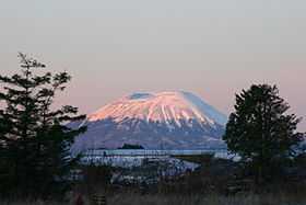 Mount Edgecumbe in December 2004. | |
| Elevation | 3,201 ft (976 m) |
| Prominence | 3,201 ft (976 m) |
| Location | |
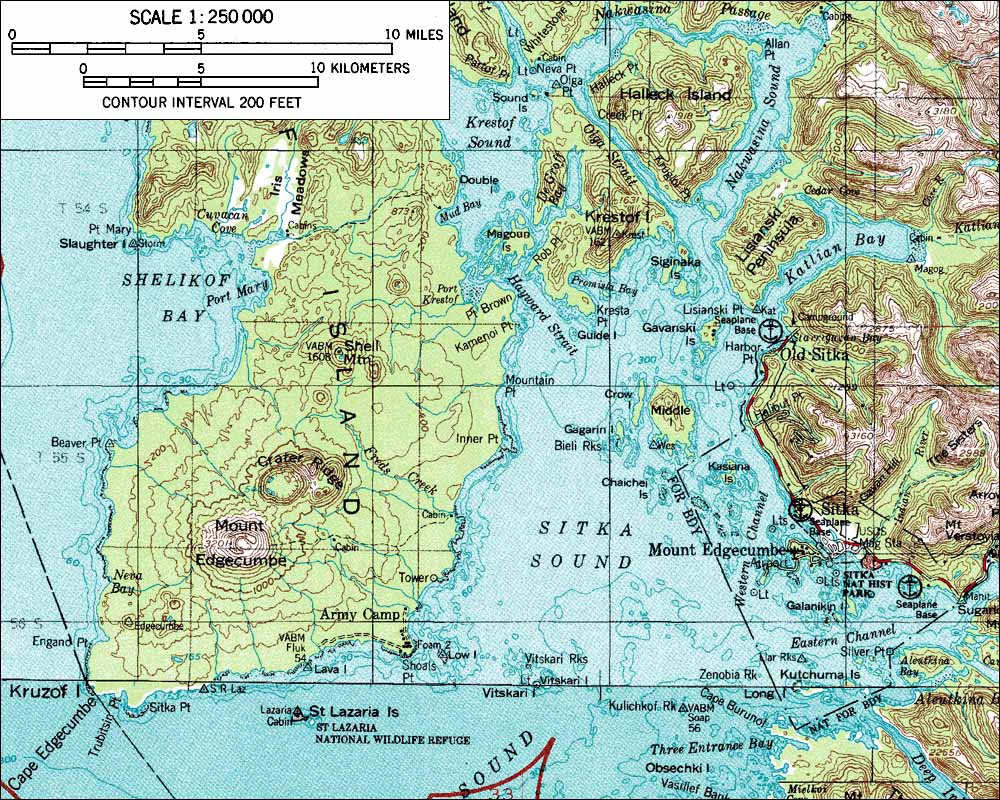
| Location | Kruzof Island, Sitka City and Borough, Alaska, U.S. |
| Coordinates | 57°03′05″N 135°45′31″W / 57.05139°N 135.75861°WCoordinates: 57°03′05″N 135°45′31″W / 57.05139°N 135.75861°W |
| Topo map | USGS Sitka A-6 |
| Geology | |
| Type | Dacite stratovolcano |
| Age of rock | < 600,000 yr |
| Last eruption | 2220 BCE ± 100 years |
| Climbing | |
| First ascent | 1803 by Urey Lisianski |
| Easiest route | Hike |


Mount Edgecumbe is the current name of a dormant volcano located at the southern end of Kruzof Island, Alaska, of which it is the highest point. In the Tlingit language it is called L’ux.[1] Mt. Edgecumbe is a local landmark and a tourist attraction.
Naming
Mount Edgecumbe was named by British Captain James Cook in 1778 after a hill overlooking Plymouth Harbor, England, or possibly for George, Earl of Edgcumbe.[2] It had previously been named Montaña de San Jacinto (to La Pérouse "Mount Saint Hyacinth") in 1775 by Spanish explorer Juan de la Bodega to honor the saint whose day it was.[3]
Ascent
Mount Edgecumbe can be ascended by a 6.7 Miles (one way), difficult day hike - Muddy and wet in places, last 3 miles steep climb, bears may be present.[4] The trail and original cabin were constructed by the Civilian Conservation Corps.
Eruptions
False eruption
On April 1, 1974, a local prankster named Oliver (Porky) Bickar flew in and ignited 100 old tires in the crater, convincing nearby residents of Sitka, Alaska that the volcano was erupting. Round the rim of the volcano someone had spraypainted "April Fool" in 50ft letters. Bickar had been planning the prank for four years.[6]
See also
- List of volcanoes in the United States of America
References
- ↑ Joseph, Charlie; Brady, I.; Makinen, E.; David, R.; Davis, V.; Johnson, A.; Lord, N. (2001). "Sheet’kwaan Aani Aya". Sitka Tribe of Alaska. Retrieved 27 October 2009.
- ↑ Wagner, Henry (1937). The Cartography of the Northwest Coast of America to the Year 1800. Berkeley: University of California Press. p. 385.
- ↑ Orth, Donald J. (1967). Dictionary of Alaska Place Names, Geological Survey, Professional Paper 567. Washington: United States Government Printing Office.
- ↑ "Mount Edgecumbe Trail". http://www.sitkatrailworks.org/''. Sitka Trail Works Inc. Retrieved 10 February 2015.
- ↑ "Mount Edgecumbe". Global Volcanism Program. Smithsonian Institution.
- ↑ Lamont, Tom (1 April 2012). "The 10 best April fools". The Guardian (London). Retrieved 2012-04-01.