Mount Douglas, Greater Victoria
Mount Douglas (SENĆOŦEN: pq̕áls or PKOLS) is a prominent, 260 m (853 ft) hill on the ancestral lands of the Saanich people, currently claimed by the Greater Victoria municipality. English colonizers changed the name for the second governor of the Colony of Vancouver Island, Sir James Douglas, who oversaw the signing of the Douglas Treaties. One of these treaties was signed at the top of PKOLS in 1852, the North Saanich Treaty.[1] This treaty and those who translated it to attain signatures misled the local First Nations peoples, who believed they were signing an agreement for shared land use, not a permanent surrender of the land. Oral histories show that the Saanich nations were told that this was a peace treaty and that there would be no change to their way of life. [2] This promise was broken with the restriction of fishing and hunting rights and the later development of the reserve system.
Name
The original name was PKOLS [pq̕áls], used by the aboriginal Saanich and Songhees people. In 2013 a movement was started to reestablish its original name.[3][4][5] The Reclaim PKOLS movement has appealed to the BC Geographical Names Office for a formal name change. There has yet to be an approval of this petition. On May 22nd, 2013, a new "PKOLS" sign was brought to the top of the mountain by a group of WSANEC and Lekwungen chiefs, joined by several hundred supporters . This sign was later removed by the Saanich Parks Board, without consultation, due to their concerns about the anchor bolts interfering with electrical wiring. It was later re-installed at a different location.[6] PKOLS means "White Head" in SENĆOŦEN dialect. This mountain was a culturally significant gathering and meeting place SENĆOŦEN and Lekwungen peoples, a site for ceremonies and sharing important news. [7]
In the mid-nineteenth century, it was called Cedar Hill, and was home to logging operations. Local mills supplied the growing city of Victoria, including the original Hudson's Bay Company fort, transporting lumber south along present day Cedar Hill Road. It was brought under protected status in 1889. Finding no cedars on the hill called "Cedar Hill," Captain Henry Kellett renamed it "Mount Douglas," as recorded in the Fort Victoria Journal by Roderick Finlayson.[8] Although this informal renaming occurred in Douglas' lifetime (it was given the appellation "Mount" in order to honour the governor's status), the name "Mt. Douglas" was not officially adopted until 1910.
The neighbourhood
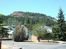
The namesake neighbourhood around the base of Mt. Douglas is a mix of residential neighbourhoods, hobby farms and working farms, roughly bounded by Cedar Hill Road, Cordova Bay Road, the Blenkinsop Valley and Parkside Crescent. The farms of the Blenkinsop Valley (such as Madrona Farm) are protected by the provincial Agricultural Land Reserve.
Mount Douglas Mining Cave
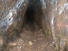
Mount Douglas has many trails. One trail in particular, on its south side (near the north-most point of Glendenning Trail), has an old abandoned mine. The mine has a small entrance, but it opens up inside. The mine is about 50 to 60 feet (15.24 to 18.29 m) in length.
References
- ↑ http://nationsrising.org/action-reclaim-pkols-may-22-2013/
- ↑ http://web.uvic.ca/igov/research/pdfs/Janice%20Knighton%20CGP%20Aug.%202004.pdf
- ↑ "Reclaim PKOLS". Retrieved 2013-05-22.
- ↑ Hill, Edward (2013-05-18). "First Nations act to reclaim name of Mount Doug". Victoria News. Retrieved 2013-05-22.
- ↑ Mount Douglas Name Change Supported By Noam Chomsky, Canadian Press, May 22, 2013
- ↑ http://www.vicnews.com/news/229311701.html
- ↑ http://socialcoast.org/taking-the-names-down-from-the-hill/item/history
- ↑ http://www.fortvictoriajournal.ca/1846-august.php?hl=de&q=hill
External links
- Description of the location and nomenclature from the BC Ministry of Sustainable Resource Management.
- Description of the park from the Saanich municipal website.
- A description of the area, including some historical information.
- Website for Mount Douglas High School
| ||||||||||||||||||
Coordinates: 48°29′35″N 123°20′48″W / 48.49307°N 123.34679°W