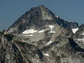
Mount Despair (Washington)
For the mountain in Montana, see Mount Despair (Montana).
| Mount Despair | |
|---|---|
 | |
| Elevation | 7,296 ft (2,224 m) NAVD 88[1] |
| Prominence | 1,852 ft (564 m)[1] |
| Location | |
| Location | Whatcom County, Washington, U.S. |
| Range | Cascade Range, North Cascades |
| Coordinates | 48°44′14″N 121°22′36″W / 48.737333°N 121.376777°WCoordinates: 48°44′14″N 121°22′36″W / 48.737333°N 121.376777°W[1] |
| Topo map | USGS Damnation Peak |
Mount Despair is a rugged mountain in the North Unit of North Cascades National Park in Washington state. Northeast of Mount Despair lies the Picket Range.
The mountain's name was given by Lage Wernstedt of the U.S. Forest Service who mapped the region in the 1920s. The name Mount Despair first appeared on Forest Service maps in 1931.[2]
Nearby peaks
References
- ↑ 1.0 1.1 1.2 "Mount Despair, Washington". Peakbagger.com.
- ↑ Beckey, Fred W. (1995). Cascade Alpine Guide: climbing and high routes, Vol. 3, Rainy Pass to Fraser River (2nd ed.). Mountaineers Books. p. 86. ISBN 978-0-89886-423-6.
External links
- "Mount Despair" (map). TopQuest.com.
- "Mount Despair". Peakware.com.