Mount Conner
| Mount Conner | |
|---|---|
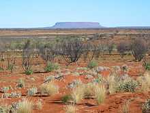
 Mount Conner seen from the road to Uluru | |
| Elevation | 859 m (2,818 ft)AHD |
| Location | |
| Location | Northern Territory, Australia |
| Coordinates | 25°29′49″S 131°54′00″E / 25.497°S 131.900°ECoordinates: 25°29′49″S 131°54′00″E / 25.497°S 131.900°E |
Mount Conner, also known as Attila and Artilla, and occasionally found as Mount Connor, is an Australian mountain located in the southwest corner of the Northern Territory, 75 kilometres (47 mi) southeast of Lake Amadeus at the border of the vast Curtin Springs cattle station. It reaches to 859 metres (2,818 ft) above sea level and to 300 metres (984 ft) above ground level.[1][2]
Mount Conner is a flat-topped and horseshoe-shaped inselberg/mesa, part of the same vast rocky substrate thought to be beneath Uluru/Ayers Rock and Kata Tjuta/Olgas. It can easily be confused with Uluru, since it can be seen from the road to Uluru and Kata Tjuta, when approaching from Alice Springs. It was named Mount Conner by William Gosse in 1873 after South Australian politician M. L. Conner.[1][2]
Geology
Mt Conner consists of conglomerates, sandstones, siltstones, and mudstones of the Late Ediacaran–Early Cambrian Winnall beds and the Middle Cryogenian–early/mid Ediacaran Inindia beds. The Winnall beds form the upper part of Mt Conner. The summit consists of grey to coarse-grained sandstone with pebble layers and minor beds of pebble conglomerate and siltstone that from a prominent scarp. The Winnall beds that underlie this scarp is a recessive unit composed of dark brown micaceous siltstone, mudstone, and fine-grained sandstone. The lower part of Mt. Conner consists of planar and trough cross-bedded, medium to coarse-grained, grey-brown sandstones, dark brown siltstones, and cherts, of the Inindia beds. The upper part of the Inindia beds are fluvial deposits. The sides of Mt Conner are also blanketed by scree (talus) and its top is blanketed by colluvium. The base of Mt Conner is surrounded by alluvium.[3][4][5]
The summit of Mt Conner, along with the summits of low domes in the Kata Tjuta complex and summit levels of Uluru, is an erosional remnant of a Cretaceous geomorphic surface. It is considered to a classic example of an inselberg created by erosion of surrounding strata.[6]
References
- ↑ 1.0 1.1 "Mount Conner". Gazetteer of Australia online. Geoscience Australia, Australian Government.
- ↑ 2.0 2.1 "Mount Conner". Encyclopædia Britannica Online. Encyclopædia Britannica. 2011.
- ↑ Young, DN, N Duncan, A Camacho, PA Ferenczi, and TLA Madigan (2002a) Ayers Rock, SG 52-8 map, 1:250 000 Geological Series (Second Edition), Northern Territory Geological Survey. scale 1:250 000, Darwin, Northern Territory Geological Survey, Australia.
- ↑ Young, DN, N Duncan, A Camacho, PA Ferenczi, and TLA Madigan (2002b) Ayers Rock, SG 52-8 Expanatory Text, 1:250 000 Geological Series (Second Edition). scale 1:250 000, Darwin, Northern Territory Geological Survey, Australia.
- ↑ Edgoose, CJ (2012) The Amadeus Basin, central Australia. Episodes. 35(1):257-263.
- ↑ Twidale, CR (2007) Ancient Australian Landscapes. Rosenberg Publishing, Kenthurst, New South Wales. 144 pp.
Additional sources
- Ayers Rock Geology Map (Map) (1st ed.). 1:250,000. Sheet SG52-8. Northern Territory Geological Survey. 1967.
- Ayers Rock Geology Map (Map) (2nd ed.). 1:250,000. Sheet SG52-8. Northern Territory Geological Survey. 2002.
- Johnson, David (2004). The Geology of Australia. Cambridge University Press. ISBN 0-521-84121-6.
- Thompson, R B (1995). A Guide to the Geology and Landforms of Central Australia. Alice Springs: Northern Territory Geological Survey. ISBN 0-7245-2527-0.