Mount Cereme
| Mount Cereme | |
|---|---|
 | |
| Elevation | 3,078 m (10,098 ft)[1] |
| Listing |
Ultra Ribu |
| Location | |
| Location | Java, Indonesia |
| Coordinates | 6°53′31″S 108°24′00″E / 6.892°S 108.40°E |
| Geology | |
| Type | Stratovolcano |
| Last eruption | March 1951 |
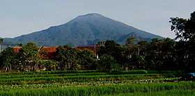
Mount Cereme or Mount Ciremai (or Ciremay) is a dominating symmetrical stratovolcano in West Java, Indonesia. It is located to the southwest of the major town of Cirebon. Mt Ciremai is strikingly visible towards the south from the main west-east (Jakarta-Surabaya) rail link along the north coast of Java.
At the summit of Mt Ciremai there is a 4.5 × 5 km wide caldera. Eruptions are relatively infrequent in historical time but explosive activity and lahars from the summit have been recorded.[1] Mount Ceremai is especially significant because it is the highest mountain in the province of West Java. The name Cereme or Ciremai is derived from Sundanese word for Otaheite gooseberry.
There are numerous recreational and tourist sites on the slopes of Mt Ciremai. Various sites, including parks and cafes, attract crowds of visitors from Cirebon. The museum at Linggajati on the slopes of Mt Ceremai which records the important historical event of the Linggadjati Agreement during the struggle for Indonesian Independence in 1946 attracts many visitors during weekends. The Mt Ciremai National Park extends for a considerable distance around the slopes of the mountain.
On Mt Ciremai, as on many other mountains up and down Java, there has been serious deforestation in recent decades. It was reported in late 2012 that forest destruction on Mt Ciremai had reached 4,000 ha out of a total of 15,000 ha. Causes are said to include illegal logging, sand quarrying (often for construction purposes in nearby areas), and forest fires.[2] Some of the consequences of deforestation of this kind, evident in the Cirebon area close to the sea near Mt Ciremai, include extensive siltation of the rivers which flow northwards into the Java sea and more frequent flooding in lowland areas.[3]
Climbing Mt Ciremai
Groups of hikers, including parties of students, regularly climb the peak. The climb, which often takes 12 hours or more for the round trip, involves camping on the mountain for a night for some groups. As is frequently the case in other parts of Indonesia, groups are expected to register with local officials before beginning the climb. Care is needed because inexperienced hikers sometimes run into considerable difficulties.[4] Groups often begin the climb from Linggajati in the east, Palutungan from the south near the town of Cigugur, or Majalengka to the west.
A useful guide to climbing Mt Ciremai is on the Gunung Bagging website for the mountain.
See also
References
- ↑ 1.0 1.1 "Cereme". Global Volcanism Program. Smithsonian Institution.
- ↑ Nana Rukmana, 'Environment Watch: Action needed to stop Cirebon destruction', The Jakarta Post, 24 December 2010.
- ↑ Nana Rukmana, 'Northern coastal areas of West Java vulnerable to flooding', The Jakarta Post, 1 September 2012.
- ↑ Nana Rukmana, 'Missing climbers on Mt Ceremai found safe', The Jakarta Post, 29 May 2009.