Mount Arrowsmith
For other mountains with this name, see Mount Arrowsmith (disambiguation).
| Mount Arrowsmith | |
|---|---|
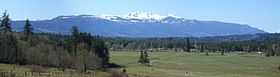 Mount Arrowsmith from Highway 19 | |
| Elevation | 1,819 m (5,968 ft)[1] |
| Prominence | 1,429 m (4,688 ft)[1] |
| Location | |
 Mount Arrowsmith | |
| Coordinates | 49°13′25″N 124°35′40″W / 49.22361°N 124.59444°WCoordinates: 49°13′25″N 124°35′40″W / 49.22361°N 124.59444°W[1] |
| Topo map | NTS 92F/02 |
| Climbing | |
| First ascent | John Macoun 1887 |
| Easiest route | scramble |
Mount Arrowsmith is the largest mountain on southern Vancouver Island. Its dominant rock is basalt. The mountain is contained within a UNESCO Biosphere Reserve and as of September 18, 2009 is designated part of 1,300 hectare Mt. Arrowsmith Regional Park.
History
The first recorded ascent was made by botanist John Macoun in 1887. Macoun was a botanist to the Geological Survey of Canada. Mount Waddington was first seen from the peak of Mount Arrowsmith by Don and Phyllis Munday in 1925 (see also Mount Munday). The mountain was named about 1853 by Captain Richards for cartographers, Aaron Arrowsmith and his nephew John Arrowsmith.[2]:24
The mountain was known as "Kulth-ka-choolth", meaning "jagged face", in the Coast Salish language.[3]
References
- ↑ 1.0 1.1 1.2 "Mount Arrowsmith". Bivouac.com. Retrieved 2006-06-05.
- ↑ Walbran, Captain John T. (1971). British Columbia Place Names, Their Origin and History (Facsimile reprint of 1909 ed.). Vancouver/Toronto: Douglas & McIntyre. ISBN 0-88894-143-9. OCLC 15852328.
- ↑ "Mount Arrowsmith". BC Geographical Names. Retrieved 2010-02-20.
External links
| Wikimedia Commons has media related to Mount Arrowsmith. |
- "Mount Arrowsmith". BC Geographical Names.
- Mount Arrowsmith website
- Mount Arrowsmith biosphere
- Judges Route, Club Tread
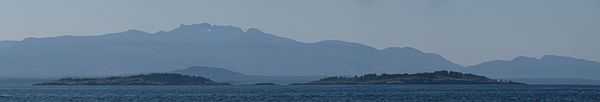
Mount Arrowsmith from the Strait of Georgia with
Ballenas Islands in the foreground