Mount Ararat
| Mount Ararat | |
|---|---|
|
| |
| Elevation |
5,137 m (16,854 ft) See Elevation section |
| Prominence |
3,611 m (11,847 ft) Ranked 48th |
| Listing |
Country high point Ultra |
| Location | |
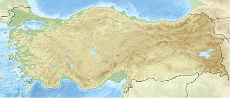 Mount Ararat Location in Turkey | |
| Location | Nearest city, approach for climbers:[note 1] Doğubeyazıt, Ağrı Province, Turkey[1] |
| Range | Armenian Highlands |
| Coordinates | 39°42.113′N 44°17.899′E / 39.701883°N 44.298317°ECoordinates: 39°42.113′N 44°17.899′E / 39.701883°N 44.298317°E[2] |
| Geology | |
| Type | Stratovolcano |
| Last eruption | 1840[3] |
| Climbing | |
| First ascent |
1829 Dr. Friedrich Parrot and Khachatur Abovian[4] |
_view_from_plane_under_naxcivan_sharur.jpg)


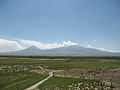
Mount Ararat (Turkish: Ağrı Dağı; Armenian: Արարատ or Masis Մասիս, see below for its other names and etymology) is a snow-capped and dormant compound volcano in Turkey. It consists of two major volcanic cones: Greater Ararat (the highest peak in Turkey and the entire Armenian plateau with an elevation of 5,137 m (16,854 ft) and Lesser Ararat (with an elevation of 3,896 m (12,782 ft).[5]
The Ararat massif is about 40 km (25 mi) in diameter. The Iran-Turkey boundary skirts east of Lesser Ararat, the lower peak of the Ararat massif. It was in this area that, by the Tehran Convention of 1932, a border change was made in Turkey's favour, allowing it to occupy the eastern flank of Lesser Ararat.[6]
Mount Ararat in Judeo-Christian tradition is associated with the "Mountains of Ararat" where, according to the Book of Genesis, Noah's Ark came to rest. It also plays a significant role in Armenian culture and nationalism. The mountain can be seen on the coat of arms of Armenia.
Names and etymology
- Ararat - The Bible says that Noah's Ark landed on the mountains of Ararat. This does not refer to any specific mountain or peak, but rather a mountain range within the region of Ararat, which was the name of an ancient kingdom of Urartu.[7] Nonetheless, one particular tradition identifies the mountain as Mount Masis, the highest peak in the Armenian Highland, which is therefore called Mount Ararat.[7] (As opposed to the Armenian and European tradition, Semitic tradition identifies the mountain as Judi Dagh located in Turkey near Cizre.)[note 2] According to the medieval Armenian historian Moses of Khoren in his History of Armenia, the plain of Ayrarat (directly north of the mountain) got its name after King Ara the Handsome.[8] Here the Assyrian Queen Semiramis is said to have lingered for a few days after the death of Ara.[8] According to Thomson, the mountain is called Ararat (Armenian: Արարատ) corresponding to Ayrarat, the name of the province.[note 3][note 4]
- Ağrı Dağı (Mountain of Ağrı) - The Ottoman Turkish name was 'Aghur Dagh' اغـر طﺎﻍ [note 5] which means 'heavy mountain'. Ağrı is also a province in the Eastern Anatolian Region of Turkey, which derived its name from the mountain in 1949.[9] During the Ottoman Empire era, Ağrı village was originally called Karakilise (black church).[10]
- Masis (Armenian: Մասիս) - is the Armenian name for the peak of Ararat, the plural 'Masiq' (Armenian: Մասիք) may refer to both peaks.[8] The History of Armenia derives the name from a king Amasya, the great-grandson of the Armenian patriarch Hayk, who is said to have called the mountain Masis after himself.[8]
- Çiyayê Agirî (Fiery Mountain), Çiyayê Alavhat and Grîdax (Kurdish): This entire tree name referred a volcanic characteristic of Mount Ararat. It is the only name to have a clear, descriptive etymology while also indicating the preservation of folk memory.[10]
- Kuh-e-Nuh (Noah's Mountain): (Persian: کوه نوح, IPA: [ˈkuːhe ˈnuːx], Kuh-e Nuh), also influenced by the flood story, this time via the Islamic view of Noah.[10]
Geography
Mount Ararat is located in the Eastern Anatolia Region of Turkey between Doğubeyazıt and Iğdır, near the border with Iran, Armenia and Nakhchivan exclave of Azerbaijan, between the Aras and Murat Rivers.[1] Its summit is located some 16 km (10 mi) west of the Turkey-Iran border and 32 km (20 mi) south of the Turco-Armenian border. The Ararat plain runs along its northwest to western side.
Elevation
An elevation of 5,165 m (16,946 ft) for Mount Ararat is still given by some authorities. However, a number of other sources, such as public domain and verifiable SRTM data[11] and a 2007 GPS measurement show that the alternatively widespread figure of 5,137 m (16,854 ft) is probably more accurate, and that the true elevation may be even lower due to the thick layer of snow-covered ice cap which permanently remains on the top of the mountain. 5,137 m is also supported by numerous topographic maps.[12]

Summit Ice Cap
Mount Ararat has an ice cap on its summit. Since at least about 1957, it has been shrinking. In the late 1950s, Blumenthal[13] observed that there existed 11 outlet glaciers emerging from a summit snow mass that covered about 10 km2 (3.9 sq mi). At that time, it was found that the present glaciers on the summit of Ararat to extend as low as an elevation of 3,900 meters (12,800 ft) on the north-facing slope, and an elevation of 4,200 meters (13,800 ft) on its south-facing slope.[13] Using pre-existing aerial imagery and remote sensing data, Sarıkaya[14][15] and others studied the extent of the ice cap on Mount Ararat between 1976 and 2011. They discovered that this ice cap had shrank to 8.0 km2 (3.1 sq mi) by 1976 and to 5.7 km2 (2.2 sq mi) by 2011. They calculated that between 1976 and 2011, the ice cap on top of Mount Ararat had lost 29% of its total area at an average rate of ice loss of 0.07 km2 (0.027 sq mi) per year over 35 years. This rate is consistent with the general rates of retreat of other Turkish summit glaciers and ice caps that have been documented by other studies.[15]
Blumenthal[13] estimated that the snow line had been as low as 3,000 meters (9,800 ft) in elevation during the Late Pleistocene. Such a snow line would have created an ice cap of 100 km2 (39 sq mi) in extent. However, he observed a lack of any clear evidence of prehistoric moraines other than those which were close to the 1958 glacier tongues. Blumenthal explained the absence of such moraines by the lack of confining ridges to control glaciers, insufficient debris load in the ice to form moraines, and their burial by later eruptions. Years later, Birman[16] observed on the south-facing slopes a possible moraine that extends at least 300 meters (980 ft) in altitude below the base of the 1958 ice cap at an elevation of 4,200 meters (13,800 ft). He also found two morainal deposits that were created by a Mount Ararat valley glacier of Pleistocene, possibly Wisconsinan (Last Glacial Maximum) age downvalley from Lake Balik Golu. The higher moraine lies at an altitude of about 2,200 meters (7,200 ft) and the lower moraine lies at an altitude of about 1,800 meters (5,900 ft). The lower moraine occurs about 15 kilometers (9.3 mi) downstream from Lake Balik Golu. Both moraines are about 30 meters (98 ft) high. It is suspected that Lake Balik Golu occupies a glacial basin.[16]

Geology
Mount Ararat is a polygenic, compound stratovolcano. Covering an area of 1,100 km2 (420 sq mi), it is the largest volcanic edifice within the region. Along its northwest–southeast trending long axis, Mount Ararat is about 45 kilometers (28 mi) long and is about 30 kilometers (19 mi) long along its short axis. It consists of about 1,150 km3 (280 cu mi) of dacitic and rhyolitic pyroclastic debris and dacitic, rhyolitic, and basaltic lavas.[5]
Mount Ararat consists of two distinct volcanic cones, Greater Ararat and Lesser Ararat (Little Ararat). The western volcanic cone, Greater Ararat, is a steep-sided volcanic cone that is larger and higher than the eastern volcanic cone. Greater Ararat is about 25 kilometers (16 mi) wide at the base and rises about 3 kilometers (1.9 mi) above the above the adjacent floors of the Iğdir and Doğubeyazıt basins. The eastern volcanic cone, Lesser Ararat, is 3,896 meters (12,782 ft) high and 15 kilometers (9.3 mi) across. These volcanic cones, which lie 13 kilometers (8.1 mi) apart, are separated by a wide north–south-trending crack. This crack is the surface expression of an extensional fault. Numerous parasitic cones and lava domes have been built by flank eruptions along this fault and on the flanks of both of the main volcanic cones.[5]
Mount Ararat lies within a complex, sinistral pull-apart basin that originally was a single, continuous depression. The growth of Mount Ararat partitioned this depression into two smaller basins, the Iğdir and Doğubeyazıt basins. This pull-apart basin is the result of strike-slip movement along two en-echelon fault segments, the Doğubeyazıt–Gürbulak and Iğdir faults, of a sinistral strike–slip fault system. Tension between these faults, not only formed the original pull-apart basin, but created a system of faults, exhibiting a horsetail splay pattern, that control the position of the principal volcanic eruption centers of Mount Ararat and associated linear belt of parasitic volcanic cones. The strike-slip fault system within which Mount Ararat located is the result of north–south convergence and tectonic compression between the Arabian Platform and Laurasia that continued after the Tethys Ocean closed during the Eocene Epoch along the Bitlis–Zagros suture.[5][17][18]
Geological History
During the early Eocene and early Miocene, the collision of Arabian platform with Laurasia closed and eliminated the Tethys Ocean from the area of what is now Anatolia. The closure of these masses of continental crust, collapsed this ocean basin by middle Eocene and resulted in a progressively shallowing of the remnant seas, until the end of early Miocene period. Post-collisional tectonic convergence within the collision zone resulted in the total elimination of the remaining seas from East Anatolia, at the end of early Miocene, crustal shortening and thickening across the collision zone, and uplift of the East Anatolian–Iranian plateau. Accompanying this uplift was extensive deformation by faulting and folding, which resulted in the creation of numerous local basins. The north–south compressional deformation continues today as evidenced by ongoing faulting, volcanism, and seismicity.[5][17][19]
Withn Anatolia, regional volcanism started middle-late Miocene. During the late Miocene–Pliocene period, widespread volcanism blanketed the entire East Anatolian–Iranian plateau under thick volcanic rocks. This volcanic activity has continued uninterrupted until historical times. Apparently, it reached a climax during the latest Miocene–Pliocene, 6 to 3 Ma. During the Quaternary, the volcanism became restricted to a few local volcanoes such as Mount Ararat. These volcanoes are typically associated with north–south tensional fractures formed by the continuing the north–south shortening deformation of Anatolia.[5]
In their detailed study and summary of the Quaternary volcanism of Anatolia, Yilmaz[5] and others recognized four phases to the construction of Mount Ararat from volcanic rocks exposed in glacial valleys deeply carved into it flanks. First, they recognized a fissure eruption phase of Plinian-subPlinian fissure eruptions that deposited more than 700 meters (2,300 ft) of pyroclastic rocks and a few basaltic lava flows. These volcanic rocks were erupted from approximately north northwest–south southeast-trending extensional faults and fissures prior to the development of Mount Ararat. Second, a cone-building phase began when the volcanic activity became localized at a point along a fissure. During this phase, the eruption of successive flows of lava up to 150 meters (490 ft) thick and pyroclastic flows of andesite and dacite composition and the following eruption of basaltic lava flows, formed the Greater Ararat cone with a low conical profile. Third, during a climatic phase, copious flows of andesitic and basaltic lavas were erupted. During this phase, the current cones of Greater and Lesser Ararat were formed as eruptions along subsidiary fissures and cracks and flank occurred. Finally, the volcanic eruptions at Mount Ararat transitioned into a flank eruption phase during which a major north–south-trending fault offset the two cones developed along with a number of number of subsidiary fissures and cracks on the volcanos flanks. Along this fault and the subsidiary fissures and cracks, a number of parasitic cones and domes were built by minor eruptions. One subsidiary cone erupted voluminous basalt and andesite lava flows. They flowed across the Doğubeyazıt plain and along the southerly flowing Sarısu River. These lava flows formed black ʻaʻā and pāhoehoe lava flows that contain well preserved lava tubes.[5] The radiometric dating of these lava flows yielded radiometric ages of 0.4, 0.48 and 0.81 Ma.[20] Overall, radiometric ages obtained from the volcanic rocks erupted by Mount Ararat range from 1.5 to 0.02 Ma.[5]
Recent Volcanic and Seismic Activity
The chronology of Holocene volcanic activity associated with Mount Ararat is poorly documented. However, either archaeological excavations, oral history, historical records, or combination of these data provide solid evidence that volcanic eruptions of Mount Ararat occurred in 2500–2400 BC, 550 BC, possibly in 1450 AD and 1783 AD, and definitely in 1840 AD. Archaeological evidence demonstrates that explosive eruptions and pyroclastic flows from the northwest flank of Mount Ararat destroyed and buried at least one Koura–Arax culture settlement and caused numerous fatalities in 2500–2400 BC. Oral histories indicated that a significant eruption of uncertain magitude occurred in 550 BC and minor eruptions of uncertain nature might have occurred in 1450 AD and 1783 AD. Historical records and oral history document a phreatic eruption and pyroclastic flow from radial fissues on the upper north flank of Mount Ararat and a possibly associated earthquake of magnitude 7.4 that caused severe damage and numerous casualties in 1840 AD. Up to 10,000 people in the Mount Ararart region died in the earthquake, including 1900 villagers in the village of Akory who were killed by a gigantic landslide and subsequent debris flow. In addition, this combination of landslide and debris flow destroyed the town of Aralik, several villages, and Russian military barracks. It also temporarily dammed the Sevjour River.[3][18][19][21] According to the interpretation of historical and archaeological data, strong earthquakes not associated with volcanic eruptions also occurred the area of Mount Ararat in 139, 368, 851–893, and 1319 AD. During the 139 AD earthquake, a large landslide that caused many casualties and was similar to the 1840 AD landslide originated from the summit of Mount Ararat.[18][19][22]
Climbing Mount Ararat
First recorded ascent in modern times
| Wikisource has original text related to this article: |
Dr. Friedrich Parrot, with the help of Khachatur Abovian, was the first explorer in modern times to reach the summit of Mount Ararat, subsequent to the onset of Russian rule in 1829.[4] Abovian and Parrot crossed the Aras River and headed to the Armenian village of Agori situated on the northern slope of Ararat 4,000 feet (1,200 m) above sea level. Following the advice of Harutiun Alamdarian of Tbilisi, they set up a base camp at the Monastery of Saint Jacob some 2,400 feet (730 m) higher, at an elevation of 6,375 feet (1,943 m). Abovian was one of the last travelers to visit Agori and the monastery before a disastrous earthquake completely buried both in May 1840. Their first attempt to climb the mountain, using the northeastern slope, failed as a result of lack of warm clothing.
Six days later, on the advice of Stepan Khojiants, the village chief of Agori, the ascent was attempted from the northwestern side. After reaching an elevation of 16,028 feet they turned back because they did not reach the summit before sundown. They reached the summit on their third attempt at 3:15 p.m. on October 9, 1829. Abovian dug a hole in the ice and erected a wooden cross facing north. Abovian also picked up a chunk of ice from the summit and carried it down with him in a bottle, considering the water holy. On November 8, Parrot and Abovian climbed up Lesser Ararat. Impressed with Abovian's thirst for knowledge, Parrot arranged for a Russian state scholarship for Abovian to study at the University of Dorpat in 1830. In 1845, the German mineralogist Otto Wilhelm Hermann von Abich climbed Ararat with Abovian. Abovian's third and last ascent to Ararat was with the Englishman Henry Danby Seymour in 1846.
Later ascents
| Date | Person(s) climbed | Comment |
|---|---|---|
| October 9, 1829 | Friedrich Parrot and Khachatur Abovian | First ascent of the summit of Mount Ararat Started from the monastery of St. Jacob (Surb Hakob) and made the ascent by the north-western slope.[4] |
| August 5, 1834 | Kozma Spassky-Avtonomov | Climbed Ararat from Akori, to prove that the stars could be seen at noon and used ice from the summit to baptize his son.[23] |
| August 8–9, 1835 | Karl Behrens[23] | Imperial Russian Geographical Society attested to the expedition. |
| July 29, 1845 | Otto Wilhelm Hermann von Abich | Armenian guide led him up the southeastern face from Sardar Bulak, a Cossack station with a well, located in the middle of the wide semicircular valley or sloping plain between Greater and Lesser Ararat. Abich I & II Glaciers named after him.[23] Climbed western and eastern summit.[4] They climbed from Sardar Bulak. |
| 1846 | Henry Danby Seymour | With 2 Armenians and a Cossack officer Climbed from New Akori.[23] |
| August 1–9, 1850 | Iosif Khodko (Иосиф Ходько), P.H. Moritz, N. V. Khanikov and many others | Ascended from Sardar Bulak. Six days were spent on top of Mt. Ararat[23] |
| June 29, 1856 | English Major Robert Stuart | With major Alick J. Fraser, Reverend Walter Thursby, James Theobald, John Evans of Darley Abbey. They climbed from Bayazid. |
| August 31, 1876 | James Bryce | He was alone. And he founded a timber at 3965 m (13,500 ft)[23] He climbed from Sardar Bulak. |
| 1878 | G. P. Baker | He climbed from Sardar Bulak. |
| 1882 | Sivoloboff | |
| August 13, 1888 | Yevgeniy Markov | With Ivan Kovalewski and Mosokevich (young lady).[23] They climbed from Saradar Bulak. |
| 1888 | Semenoff | |
| 1889 | Raphalovich and others | He climbed from Sardar Bulak. |
| July 4, 1891 | Thomas Gaskell Allen, Jr. and William Lewis Sachtleben [4] | First American ascent of the summit of Mount Ararat [4] He climbed from Bayazid. |
| 1893 | Postukhoff | He climbed from Sardar Bulak. |
| October 1893 | H. F. B. Lynch | With Rudolph Taugwalder[23] and H. B. Lynch |
| 1897 | Herr A. Oswald[23] Eine Besteigung des Ararat, Alpenclub, Berne, 1899–1900, vol. XXXV. pp. 157–183 | |
| September 5, 2009 | Erik Weihenmayer, Edwin Albert Weihenmayer, Gökmen Önay, Bahar Ganjavi, Behrouz Khabbaz Beheshti, Seyed Hassan Moghimi[24] | Erik Weihenmayer is first known blind person to reach the summit of Mount Ararat. Group guided by Gökmen Önay from Turkey. Hassan Moghimi Iran, born without one hand and is a professional cyclist.[24] |
Climbing routes, permits and guides
The climb is long, but there is a fairly easy route from the south in late summer for climbers who are familiar with the use of axe and crampons. Snow covers the last 400 m (¼ mile) year-round. There are two possible campsites on the mountain, and the glacier begins around 4,800 m (15,750 ft).

The Turkish government requires a climbing permit and use of a certified Turkish guide. Arrangements can take two months to complete.
Association with Noah

The name "Ararat" for the peak derives from the tradition linking it with the Biblical Mountains of Ararat where Noah's Ark came to rest after the great flood (Genesis 8:4).
The identification of Mount Ararat with these biblical mountains is ancient, entering Western Christianity in the fourth century, with Jerome's reading of Josephus. The Vulgata renders the Hebrew hārəy Ǎrārāṭ as montes Armeniae.
In eastern tradition (Syriac and Quranic), the biblical mountains are associated with Mount Judi in what is now northwestern Iran. But by the medieval period, the western tradition appears to have eclipsed the earlier association with Mount Judi even in Eastern Christianity, and the Mount Judi tradition is now mostly confined to the Islamic view of Noah.
Political boundaries
Mount Ararat forms a near-quadripoint between Turkey, Armenia, Azerbaijan and Iran. Its summit is located some 16 km (10 mi) west of both the Iranian border and the border of the Nakhchivan exclave of Azerbaijan, and 32 km (20 mi) south of the Armenian border.
The Turkish-Armenian-Azerbaijani and Turkish-Iranian-Azerbaijani tripoints are actually some 8 km apart, separated by a narrow strip of Turkish territory containing the E99 road which enters Nakhchivan at 39°39′19″N 44°48′12″E / 39.6553°N 44.8034°E.
The international boundaries as described have been in effect since the 1991 independence of Azerbaijan and Armenia. However, they have a longer history, having been drawn in 1923, after the conflicts of World War I and the dissolution of the Ottoman Empire that affected the region, in particular the Armenian–Azerbaijani War of 1918 to 1920, and the creation of the Republic of Turkey in the Treaty of Lausanne of 1923 regulating the Partitioning of the Ottoman Empire.
From 1923 to 1991, the border between Armenia and Azerbaijan was an internal border within the Soviet Union, between the Armenian SSR and the Nakhichevan SSR, the tripoint between Turkey, Iran and the Soviet Union from 1923 to 1991 corresponding to the current Turkish-Iranian-Azerbaijani tripoint. Prior to World War I the area had been divided between the Russian Empire, the Ottoman Empire, and the Persian Empire.
Ararat (Ağrı Dağı) was officially opened for tourism only in 1998, when the Turkish Federation of Mountaineering issued permit to climb up to the summit. Since 2004, Ararat has been part of a nature reserve.
Significance in Armenian nationalism

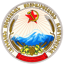
In Armenian mythology Mt. Ararat is the home of the Gods, much like Mt. Olympus is in Greek Mythology, and in the modern-era Ararat has been revered by the Armenians as symbolizing their national identity. Ararat dominates the skyline of Armenia's capital, Yerevan.[25] Ararat is the national symbol of the Republic of Armenia, being featured in the center of its coat of arms.[26] This coat of arms descends from that of the Armenian SSR, which featured Mount Ararat along with the Soviet hammer and sickle and red star behind it.[27] After the dissolution of the Soviet Union, a slightly modified version of the Democratic Republic of Armenia's coat of arms was adopted and has remained in place ever since.[26] The 2002 film Ararat by Armenian-Canadian filmmaker Atom Egoyan features Mt. Ararat prominently in its symbolism.
Mount Ararat was depicted on various Armenian dram banknotes issued in 1993-2001[note 6] and on the reverse of the Turkish 100 lira banknotes of 1972-1986.[note 7]
Depiction in symbols
| Image | Country, region, settlement Description |
|---|---|
 |
City of Tiflis (1843) coat of arms on the left upper corner |
 |
Democratic Republic of Armenia (1918-1920) coat of arms in the center |
| |
Transcaucasian Socialist Federative Soviet Republic (1922-1936) coat of arms |
 |
Armenian Soviet Socialist Republic (1937-1991) emblem |
 |
Republic of Armenia (established 1991) coat of arms in the center |
Gallery


Artistic
-

Gevorg Bashinjaghyan, 1912
Historical
|
.jpg)
.jpg)


._Floriant_Gille._Lettres_sur_le_Caucase_et_la_Crim%C3%A9e._1859.jpg)


.jpg)

See also
- 96205 Ararat is an asteroid named in the mountain's honor
- Volcanic Seven Summits
Notes
- ↑ The only permitted route to climb Mount Ararat begins in Doğubeyazıt, optionally by automobile. Ministry of Culture and Tourism (2005).
- ↑ "Against the Armenian (and European) tradition that makes Masis the landing place of Noah, the Semitic tradition associated this landing with the mountain called Judi Dagh (earlier called Ararad or Sararad) located in Kurdistan northeast of Mosul.", Hewsen, p. 15Hewsen 2001
- ↑ "Masis: the Armenian name for the mountain south of the Araxes now called Ararat (by confusion with Ayrarat, the name of the province)". The Primary History, Sebeos, p. 10, offers a different etymology, from the personal name 'Marseak'. Thomson, footnote on p. 91.Thomson 1978
- ↑ Friedrich Murad, Ararat und Masis, Studien zur armenischen Altertumskunde und Litteratur, Heidelberg, 1900. (Frederick Cornwallis Conybeare in a 1901 review states, "To anyone acquainted with Armenia, to speak of Ararat as a mountain is as if you spoke of Wales as such."
- ↑ Ağır Dağ in modern Turkish.
- ↑ Mount Ararat was depicted in the following Armenian banknotes:
- On the reverse of the 10 dram banknotes issued in 1993 (10 Dram).
- On the reverse of the 50 dram banknotes issued in 1998 (50 Dram).
- On the obverse of the 100 dram banknotes issued in 1993 (100 Dram).
- On the obverse of the 500 dram banknotes issued in 1993 (500 Dram).
- On the reverse of the 50,000 dram banknotes issued in 2001 (50,000 Dram).
- ↑ Central Bank of the Republic of Turkey. Banknote Museum: 6. Emission Group - One Hundred Turkish Lira - I. Series, II. Series & III. Series. – Retrieved on 20 April 2009.
References
- ↑ 1.0 1.1 "Ağrı – Mount Ararat". Republic of Turkey Ministry of culture and tourism (kultur.gov.tr). 2005.
- ↑ 2007 GPS survey
- ↑ 3.0 3.1 Siebert, L., T. Simkin, and P. Kimberly (2010) Volcanoes of the world, 3rd ed. University of California Press, Berkeley, California. 551 pp. ISBN 978-0-520-26877-7.
- ↑ 4.0 4.1 4.2 4.3 4.4 4.5 Early American Expedition Of Mount Ararat
- ↑ 5.0 5.1 5.2 5.3 5.4 5.5 5.6 5.7 5.8 Yilmaz, Y., Y. Güner, and F. Saroğlu (1998) Geology of the quaternary volcanic centres of the east Anatolia. Journal of Volcanology and Geothermal Research. vol. 85, pp. 173–210.
- ↑ "IBS No. 28 - Iran (IR) & Turkey (TU) 1964" (PDF), law.fsu.edu.
- ↑ 7.0 7.1 "Ararat". Jewish Virtual Library. 2008. Retrieved 27 July 2009.
- ↑ 8.0 8.1 8.2 8.3 Thomson, p. 90-98.Thomson 1978
- ↑ Turkish law 5442 changing place and city name to Turkish
- ↑ 10.0 10.1 10.2 Mount Ararat Information
- ↑ SRTM data for Mount Ararat
- ↑ Detailed topographic maps of Mount Ararat
- ↑ 13.0 13.1 13.2 Blumenthal, M.M. (1958). Vom Agrl Dag (Ararat) zum Kagkar Dag. Bergfahrten in nordostanatolischen Grenzlanden. Die Alpen. vol. 34, pp. 125-137.
- ↑ Sarıkaya, M.A. (2012) Recession of the ice cap on Mount Ağrı (Ararat), Turkey, from 1976 to 2011 and its climatic significance. Journal of Asian Earth Sciences. vol. 46, pp. 190–194.
- ↑ 15.0 15.1 Sarıkaya, M.A., and A.E. Tekeli (2014) Satellite inventory of glaciers in Turkey. In J. S. Kargel and others, eds., pp. 465-480, Global Land Ice Measurements from Space. Springer Praxis Books, Springer-Verlag, New york, New York. 876 pp. ISBN 978-3540798170
- ↑ 16.0 16.1 Birman, J.H., (1968) Glacial Reconnaissance in Turkey. Geological Society of America Bulletin. vol. 79, no. 8, pp. 1009-1026.
- ↑ 17.0 17.1 Dewey, J.F., M.R. Hempton, W.S.F. Kidd, F. Saroglum and A.M.C. Sengὃr (1986) Shortening of continental lithosphere: the neotectonics of Eastern Anatolia - a young collision zone. In M.P. Coward, and A.C. Ries, eds., pp. pp. 3-36, Collision Tectonics. Special Publication No. 19, Geological Society of London, London, United Kingdom.
- ↑ 18.0 18.1 18.2 Karakhanian, A., R. Djrbashian, V. Trifonov, H. Philip, S. Arakelian, and A. Avagian (2002) Holocene–Historical Volcanism and Active Faults as Natural Risk Factor for Armenia and Adjacent Countries. Journal of Volcanology and Geothermal Research. vol. 113, no. 1, pp. 319–344.
- ↑ 19.0 19.1 19.2 Karakhanian, A.S., V.G. Trifonov, H. Philip, A. Avagyan, K. Hessami, F. Jamali, M. S. Bayraktutan, H. Bagdassarian, S. Arakelian, V. Davtian, and A. Adilkhanyan (2004) Active faulting and natural hazards in Armenia, Eastern Turkey and North-Western Iran. Tectonophysics. vol. 380, pp. 189– 219.
- ↑ Allen, M.B., D F. Mark, M. Kheirkhah, D. Barfod, M.H. Emami, and C. Saville (2011) 40Ar/39Ar dating of Quaternary lavas in northwest Iran: constraints on the landscape evolution and incision rates of the Turkish–Iranian plateau. Geophysical Journal International. vol. 185, pp. 1175-1188.
- ↑ Арутюнян, Р. А. (2005) Катастрофическое извержение вулкана Арарат 2 июля 1840 года. Институт геологических наук НАН РА // Известия НАН Армении. Науки о земле. Т. LVIII, № 1. - C. 27 - 35.
- ↑ Taymaz, T., H. Eyidogan, and J. Jackson (1991) Source parameters of large earthquakes in the East Anatolian fault zone (Turkey). Geophysical Journal International. vol. 106, pp. 537–550.
- ↑ 23.0 23.1 23.2 23.3 23.4 23.5 23.6 23.7 23.8 Mount Ararat Search Expeditions & Early Ascents
- ↑ 24.0 24.1 Erik Weihenmayer's Blog
- ↑ "Ararat, Mount :: Mount Ararat — Britannica Online Encyclopedia". Britannica.com. Retrieved 2008-11-11.
- ↑ 26.0 26.1 "Armenia: Coat of arms". Crwflags.com. Retrieved 2008-11-11.
- ↑ "Armenia in the Soviet Union". Flagspot.net. Retrieved 2008-11-11.
Bibliography
- ^ Hewsen, Robert H. (2001), Armenia: A Historical Atlas (1st ed.), Chicago, IL: University of Chicago Press, ISBN 0-226-33228-4
- ^ Moses of Khoren; Thomson, Robert W. (1978). History of the Armenians. Cambridge, Massachusetts: Harvard University Press. ISBN 0-674-39571-9.
External links
| Wikimedia Commons has media related to Mount Ararat. |