Mount Abbot
| Mount Abbot | |
|---|---|
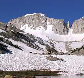 Mount Abbot, showing the north couloir. Petit Griffon is the gendarme on the right. | |
| Elevation | 13,710 ft (4,180 m) NAVD 88[1] |
| Prominence | 864 ft (263 m)[1] |
| Listing | SPS Emblem peak[2] |
| Location | |
 Mount Abbot Location in California | |
| Location | Fresno / Inyo counties, California, U.S. |
| Range | Sierra Nevada |
| Coordinates | 37°23′11″N 118°47′05″W / 37.386324°N 118.7848432°WCoordinates: 37°23′11″N 118°47′05″W / 37.386324°N 118.7848432°W[3] |
| Topo map | USGS Mount Abbot |
| Climbing | |
| First ascent | July 13, 1908 by Joseph N. Le Conte, James S. Hutchinson & Duncan McDuffie[4] |
| Easiest route | Moderate scramble, class 3[2] |
Mount Abbot is a mountain in California's Sierra Nevada, in John Muir Wilderness.[5] It is located between Mount Mills and Mount Dade along the Sierra Crest and straddles the border between Fresno and Inyo counties.
The peak was named for Henry Larcom Abbot who, in 1855, was a member of the Williamson party of the Pacific Railroad Surveys in California and Oregon.[4][6] He retired from the United States Army as a brigadier general in 1904.[4]
See also
- California 4000 meter peaks
- Thirteener
References
- ↑ 1.0 1.1 "Mount Abbot, California". Peakbagger.com. Retrieved 2009-01-16.
- ↑ 2.0 2.1 "Sierra Peaks Section List". Angeles Chapter, Sierra Club. Retrieved 2009-01-16.
- ↑ "Mount Abbot". Geographic Names Information System. United States Geological Survey. Retrieved 2009-01-16.
- ↑ 4.0 4.1 4.2 Farquhar, Francis P. (1926). Place Names of the High Sierra. San Francisco: Sierra Club. Retrieved 2009-01-16.
- ↑ "Mount Abbot". SummitPost.org. Retrieved 2011-05-31.
- ↑ Erwin G. Gudde; William Bright (10 May 2004). California Place Names: The Origin and Etymology of Current Geographical Names. University of California Press. p. 3. ISBN 978-0-520-24217-3. Retrieved 2012-04-01.