Mottola
| Mottola | ||
|---|---|---|
| Comune | ||
| Comune di Mottola | ||
 | ||
| ||
 Mottola Location of Mottola in Italy | ||
| Coordinates: 40°38′N 17°02′E / 40.633°N 17.033°ECoordinates: 40°38′N 17°02′E / 40.633°N 17.033°E | ||
| Country | Italy | |
| Region |
| |
| Province | Taranto | |
| Founded | 1300 BC[1] | |
| Government | ||
| • Mayor | Luigi Pinto (PD) | |
| Area | ||
| • Total | 212.33 km2 (81.98 sq mi) | |
| Elevation | 387 m (1,270 ft) | |
| Population (January 2008) | ||
| • Total | 16,365 | |
| • Density | 77/km2 (200/sq mi) | |
| Time zone | CET (UTC+1) | |
| • Summer (DST) | CEST (UTC+2) | |
| Postal code | 74017 | |
| Dialing code | 099 | |
| Patron saint | San Tommaso Becket | |
| Website | Official website | |

Mottola is a town and comune in the province of Taranto and region of Apulia in southeast Italy.
It stands on a hill 387 metres (1,270 ft) above mean sea level[2] in the sub-region of Murgia. It is also called "The Ionian Spy" for its strategic geographical position. From various points of the town all of the Gulf of Taranto can be seen. The economy is based mostly on agriculture and food production (olives, wine, citrus fruits, vegetables). Tourism and the manufacture of wooden fixtures are also being developed.
History
The Mottola's hill was inhabited since prehistory. In fact, in 1899 where founded a bronze closet of that historical period. The town was destroyed in 1102 after a popular rebellion to the chancellor Muarcaldo. In Medieval age, Mottola became a "castellum" and was governed by catapan Basilio Boioannes. During the Norman domination period, the town became a Diocese until 1818, when lost the title for Castellaneta. In 1653 with the notary act of Giovanni Angelo Durante di Napoli, the feud was sold to Francesco Caracciolo, the Martina Franca's duke. In the Bourbon Restoration period, Mottola follow the Italian unification events, suffering the subversive actions made by "Briganti".
Geography and climate
Mottola enjoys a typical mediterranean climate, with the greatest amounts of precipitation mainly occurring from mid-October to mid-April; any precipitation is sparse during summer and it generally takes the form of showers and/or thunderstorms. The average temperature varies from a low of 5 °C (41 °F) in January to a high of 28 °C (82 °F) in July and August. The wettest months are December and March averaging between 15 and 20 centimetres (5.9 and 7.9 in). Fog is highly usual in the town centre but it is less frequent in the outskirts, specially in the south part. Spring and fall (autumn) are considered ideal seasons for sightseeing and all kinds of outdoor activities. Summers can be particularly hot.
| Climate data for Mottola | |||||||||||||
|---|---|---|---|---|---|---|---|---|---|---|---|---|---|
| Month | Jan | Feb | Mar | Apr | May | Jun | Jul | Aug | Sep | Oct | Nov | Dec | Year |
| Average high °F (°C) | 54 (12) |
54 (12) |
58 (14) |
63 (17) |
71 (22) |
78 (26) |
83 (28) |
83 (28) |
78 (26) |
70 (21) |
61 (16) |
56 (13) |
68 (20) |
| Average low °F (°C) | 41 (5) |
41 (5) |
44 (7) |
48 (9) |
55 (13) |
62 (17) |
67 (19) |
67 (19) |
62 (17) |
56 (13) |
48 (9) |
43 (6) |
53 (12) |
| Average precipitation inches (mm) | 1.9 (48) |
1.9 (48) |
2.8 (71) |
1.2 (30) |
1.3 (33) |
1.9 (48) |
0.8 (20) |
1.2 (30) |
2 (50) |
2.3 (58) |
2 (50) |
2.8 (71) |
17.49 (444.2) |
| Source: weatherbase.com[3] | |||||||||||||
Main sights
- The cathedral (13th century, enlarged in 1507) and the Byzantine cave churches, dates from the medieval period, among which the most important are Saint Nicholas, Saint Margaret and Saint Angelus situated in frazione Casalrotto.
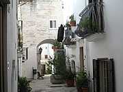
- The town has a particularly beautiful "old city" surrounded by stone walls with prominent Baroque gates leading to piazzas and winding, tiny streets. The Piazza XX Settembre is the largest open space in the city, with a greenspace in the center of a largely rectangular place.
- In the historic centre are present the Saint Mary ex-cathedral (12th century), Our Lady of Mount Carmel church (17th century), Immaculate church (17th century), Saint Mary of Constantinople chapel (16th century), and a part of Hellenistic wall (6th–4th century BCE). At the end of historic part of the town, is located a roundabout, from which can be viewed the landscape of the western part of the Province of Taranto.
Archaeological sites
Mottola country is rich of karsts called "gravine", usually situated in the south side of the town. The most important are Forcella, San Biagio, di Capo Gavito and Petruscio. The last one is certainly the most predominant.
Holy Week rites
There are numerous religious events during the Holy Week in Mottola. These events are characterized by typical processions, celebrating the Passion, made by hooded faithfuls called "paranze" in the last days of the week. The processions take place through the streets of the historical centre and end in the Our Lady of Mount Carmel church, that is also the organizer church.
Famous natives
- Nicola Legrottaglie (footballer, born 1976)
- Luigi Mastrangelo (volleyball player, born 1975)
- Giovanni D'Onghia (volleyball coach, born 1963)
- Oronzo Mario Scarano (composer, 1847–1901)
- Lorenzo Semeraro (composer and professor at Conservatorio Luigi Cherubini in Florence, 1914–89)
See also
- Terra d'Otranto
- Murgia
- Karst topography
References
- ↑ "History of Mottola".
- ↑ "Comune di Mottola Official Site".
- ↑ "Average weather for Mottola". weatherbase.com. Retrieved 22 April 2009.
External links
- Official website (Italian)
- Holy Week rites in Mottola (Italian)
- Googlemap: Mottola satellite map
- Province of Taranto (Italian)
- Region of Puglia (Italian)