Motiti Island
| Maori: Motiti | |
|---|---|
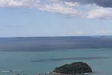
 An aerial view of Motiti Island. | |
 Motiti Island | |
| Geography | |
| Location | Bay of Plentyzw |
| Coordinates | 37°37′33″S 176°25′20″E / 37.6257°S 176.4221°E |
| Total islands | 1 |
| Major islands | 1 |
| Area | 10 km2 (3.9 sq mi) |
| Highest elevation | 57 m (187 ft) |
| Country | |
| Demographics | |
| Population | 27[1] (as of 2006) |
| Density | 2.7 /km2 (7 /sq mi) |
| Ethnic groups | Maori |
Motiti Island is located off the Bay of Plenty coast of New Zealand's North Island. It is 21 kilometres (13 mi) north-east of Tauranga and 9.4 kilometres (5.8 mi) north-east of Papamoa. There were 18 homes occupied by 27 people on the island in the 2006 Census.[1]
A relatively flat island covering some 10 km2 (3.9 sq mi), it is composed mainly of Miocene volcanic rocks, overlaid with more recent sediments in the south.[2] The principal activity on the island is agriculture, with a developing avocado plantation. Most residents and visitors travel to the island by air.
History
On 2 November 1769 during his first voyage, Cook sailed close inshore to Motiti where he reported the most extensive complex of fortified villages he had yet seen. In his journal he refers to it as the “Flat Island”.[3]
On 9 October 2011, the 45' launch M/V Excalibur ran aground offshore in bad weather. The crew of six was rescued, but the ship was considered a total loss.[4]
In 2011 the MV Rena ran aground on Astrolabe Reef. Oil from the resulting spill, as well as shipping containers and their contents, reached the shoreline of the island.[5] In October 2013, Motiti Island Residents rejected an offer by the MV Rena's owners to start a Development Project for the island.[6] The plan Included:
•Building a landing point for barges.
•Creating a one-lane, all weather road to the airstrip.
•Installing a new cellphone tower to improve communications.
•Running an underground cable from the mainland to improve power supply.
•Putting a permanent beacon on Astrolabe Reef.
•Building a Rena memorial from the ship's anchor.
See also
References
- ↑ 1.0 1.1 QuickStats About Motiti Island, 2006 Census, Statistics New Zealand. Retrieved 29 October 2010.
- ↑ Motiti Island, An Encyclopaedia of New Zealand (1966). Retrieved 29 October 2010.
- ↑ http://www.teara.govt.nz/en/1966/motiti-island
- ↑ http://www.cargolaw.com/presentations_casualties.php
- ↑ "Containers, oil to spill from 'dying' Rena". Stuff.co.nz (New Zealand). 2011-10-17. Retrieved 2011-10-20.
- ↑ http://www.3news.co.nz/Motiti-Island-residents-reject-development-plan/tabid/423/articleID/313767/Default.aspx
Coordinates: 37°37′33″S 176°25′20″E / 37.6257°S 176.4221°E