Motala ström
| Motala ström | |
| River | |
 | |
| Country | Sweden |
|---|---|
| Source | Vättern |
| - elevation | 88 m (289 ft) |
| - coordinates | 58°32′10″N 15°02′05″E / 58.53611°N 15.03472°E |
| Mouth | Baltic Sea |
| - elevation | 0 m (0 ft) |
| - coordinates | 58°37′30″N 16°15′10″E / 58.62500°N 16.25278°ECoordinates: 58°37′30″N 16°15′10″E / 58.62500°N 16.25278°E |
| Length | 100 km (62 mi) [1] |
| Basin | 15,481.2 km2 (5,977 sq mi) [2] |
| Discharge | |
| - average | 100 m3/s (3,531 cu ft/s) [1] |
 Map showing Motala ström from lake Vättern (left) to the Baltic Sea (right)
| |
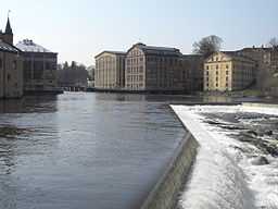
Motala ström is the river system that drains lake Vättern, the second largest lake in Sweden, into the Baltic Sea in Norrköping. It is named from the city Motala where it begins. In the early 19th century, the Göta Canal was constructed in parallel with Motala ström.
References
- ↑ 1.0 1.1 "Motala ström". Nationalencyklopedin (in Swedish). Retrieved 14 July 2010. (subscription required)
- ↑ "Län och huvudavrinningsområden i Sverige" (PDF) (in Swedish). Swedish Meteorological and Hydrological Institute. Retrieved 14 July 2010.