Mosqueiro
Coordinates: 1°06′S 48°24′W / 1.1°S 48.4°W
 Chapéu Virado neighborhood of Belém, on the island of Mosqueiro | |
 Mosqueiro (Brazil) | |
| Etymology | Probably from the Tupinambá word "moqueio"[1] |
|---|---|
| Geography | |
| Location | Pará River |
| Coordinates | 1°06′S 48°24′W / 1.1°S 48.4°W |
| Area | 191 km2 (74 sq mi) |
| Country | |
| Country |
|
| Region | North |
| State |
|
| Mesoregion | Belém Metropolitan Area |
| Demographics | |
| Population | 27,000 |
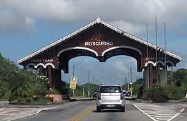
Mosqueiro is an island near the south bank of the Pará River in the Brazilian state of Pará, roughly 67 km (42 mi) north of downtown Belém.[2] The north and west of the island comprise an administrative district of the city of Belém. The island has 17 km (11 mi) of beaches with freshwater tides, which draw vacationers primarily in the dry season.[3] The largest settlement on the island is the town of Vila (often referred to simply as Mosqueiro) along the southwestern shore.
Origin of the name
Scholars have attributed the name Mosqueiro to a corruption of the native Tupinambá word moqueio, which referred to the local practice of smoking meat and fish. In the early period of Portuguese colonization, the Tupinambá supplied smoked meat and fish to the city of Belém. The Portuguese, unfamiliar with the term moqueio, called the island Mosqueiro, which was the name of several places on the Iberian Peninsula.[1] In Portuguese, the word mosqueiro means "flypaper".[4]
Landmarks
Chapéu Virado
The Chapéu Virado is located on the plaza bearing its name, at the intersection of avenues 16 de novembro and Beira Mar. It was originally a modest inn and restaurant of wood construction, dating from the heyday of the rubber plantation industry in the late nineteenth to early twentieth centuries. The hotel was constructed in a mix of European architectural styles, with allowances for the local climate. After the original structure was destroyed by fire, the mayor of Belém and the governor of Pará provided funding for its reconstruction.[1]
Capelinha do Sagrado Coração de Jesus (Chapel of the Sacred Heart of Jesus)
The Capelinha do Sagrado Coração de Jesus, located on the plaza Chapéu Virado, was constructed by Guilherme Augusto de Miranda Filho in fulfillment of a promise he made to God while ill on the island, in exchange for the return of his health. The chapel was dedicated on December 17, 1909 by the acting archbishop of Belém. On the second Sunday in December, the chapel holds a special observation for the patron saint of the people of Mosqueiro.[1]
Villa Porto Franco
Located on the plaza Chapéu Virado, the neoclassical Villa Porto Franco was once home to Portuguese artist José Franco.[1]
Sebastião Rabelo de Oliveira Bridge
The Sebastião Rabelo de Oliveira Bridge, at a length of 1,430 m (4,690 ft), connects Mosqueiro with the mainland.[5] The bridge was inaugurated on January 12, 1976, with Brazilian president Ernesto Geisel in attendance.[1]
Parque Municipal da Ilha de Mosqueiro (Mosqueiro Island Municipal Park)
Since 1988, 190 hectares (1.9 km2) of the island have been set aside as a municipal park by the city of Belém, which is seeking to promote ecotourism. The park includes 3 km (1.9 mi) of trails. The Brazilian Ministry of the Environment has approved an investment of R$200,000 (approximately US$90,000 as of 2014) in physical infrastructure, including a pier, administrative building, and research center.[2]
Wildlife
In June 2011, an amphibian identified as belonging to the species Atretochoana eiselti was photographed near Praia de Marahú, on the island of Mosqueiro. A. eiselti, previously known only from two preserved specimens dating from the late 1800s, is the largest known lungless tetrapod.[6]
Gallery
|
References
- ↑ 1.0 1.1 1.2 1.3 1.4 1.5 Paiva, Paulo (ed.). "A Ilha do Mosqueiro na Rota da História" [The Route of History of the Island of Mosqueiro]. Portal Ilha de Mosqueiro (in Portuguese). Retrieved September 16, 2014.
- ↑ 2.0 2.1 "Parque Municipal da Ilha de Mosqueiro" [Mosqueiro Island Municipal Park] (in Portuguese). Prefeitura de Belėm. Retrieved September 16, 2014.
- ↑ "Ilha de Mosqueiro". Facebook. Retrieved September 16, 2014.
- ↑ Elwes, Alfred (1907). A Dictionary of the Portuguese Language in Two Parts: 1. Portuguese-English (Fifth ed.). London: Crosby, Lockwood and Son. p. 255. Retrieved 23 February 2015.
- ↑ "Mosqueiro: a maior ilha do município de Belém" [Mosqueiro: The Largest Island in Belém] (in Portuguese). August 2, 2010. Retrieved September 17, 2014.
- ↑ Hoogmoed, Marinus Steven; Coragem, Juliano Tupan (2011). "Discovery of the largest lungless tetrapod, Atretochoana eiselti (Taylor, 1968) (Amphibia: Gymnophiona: Typhlonectidae), in its natural habitat in Brazilian Amazonia". Boletim do Museu Paraense Emílio Goeldi : Ciências Naturais 6 (3): 241–262. ISSN 1981-8114. Retrieved 22 February 2011.
External links
![]() Ilha do Mosqueiro travel guide from Wikivoyage
Ilha do Mosqueiro travel guide from Wikivoyage
 |
Baia de Marajó | Baia de Marajó |  | |
| Baia de Marajó | |
|||
| ||||
| | ||||
| Tatuoca Baia de Santo Antônio |
Caratateua Belém |
Santa Bárbara do Pará |
| |||||||||||||||||||||||||||||||||||||||||||||||||||||||||||||||||||||||||||||||||||||||||||||||||||||||||||||


