Moses-Saunders Power Dam
| Moses-Saunders Power Dam | |
|---|---|
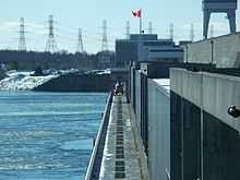 The dam's R.H. Saunders Generating Station | |
 | |
| Official name | Robert Moses-Robert H. Saunders Power Dam |
| Country | United States/Canada |
| Location |
Massena, New York Cornwall, Ontario |
| Coordinates | 45°00′23″N 74°47′42″W / 45.00639°N 74.79500°WCoordinates: 45°00′23″N 74°47′42″W / 45.00639°N 74.79500°W |
| Status | Operational |
| Construction began | 1954 |
| Opening date | 1958 |
| Owner(s) |
New York Power Authority Ontario Hydro |
| Dam and spillways | |
| Impounds | Saint Lawrence River |
| Height | 195.5 ft (60 m)[1] |
| Length | 3,216 ft (980 m) |
| Spillways | Long Sault Dam |
| Reservoir | |
| Creates | Lake St. Lawrence |
| Surface area | 100 sq mi (259 km2)[2] |
| Max. length | 30 mi (48 km) |
| Power station | |
| Commission date | R.H. Saunders: July 8, 1958-December 18, 1959[3] |
| Hydraulic head | 81 ft (25 m)[4] |
| Turbines |
R.H. Saunders: 16 x 65.3 MW fixed-pitch Kaplan-type St. Lawrence/FDR: 16 x 57 MW fixed pitch Kaplan-type[5] |
| Installed capacity |
R.H. Saunders: 1,045 MW St. Lawrence/FDR: 912 MW Total: 1,957 MW |
The Moses-Saunders Power Dam, short for Robert Moses-Robert H. Saunders Power Dam, is a dam on the Saint Lawrence River straddling the border between the United States and Canada. It is located between Massena in New York and Cornwall in Ontario. The dam supplies water to two adjacent power stations, the United States' 912 MW St. Lawrence-Franklin D. Roosevelt Power Project and Canada's 1,045 MW R.H. Saunders Generating Station. Constructed between 1954 and 1958, the dam created Lake St. Lawrence and is part of a larger project called the Saint Lawrence Seaway. Aside from providing significant amounts of renewable power, the dam regulates the St. Lawrence River and affords passage for the navigation of large vessels. Despite the enormous economic advantages to the dam, it required the relocation of 6,500 people and caused harm to the surrounding environment. Positive efforts have been made over the years to improve shoreline and fish habitats.
Background

Development of the St. Lawrence River which serves as a border between Canada and the United States was in its early stages in 1871 when the Treaty of Washington was signed, which in part demarcated the St. Lawrence River as a boundary and offered Americans greater use of the Canadian side of the river for shipping. In 1895 the Deep Waterways Commission was established to explore expanded use of the river for navigation. International shipping on the river would have a positive impact on trade between the two countries. The early St. Lawrence Seaway was proposed but railway companies in the United States stopped its construction because they felt it would reduce their profits. The Boundary Waters Treaty of 1909 further solidified cooperation between the U.S. and Canada on the river, allowing "free and open" navigation and establishing the International Joint Commission (IJC) to resolve disputes. In 1931, New York's Governor Franklin D. Roosevelt signed the Power Authority Act which allowed the development of the St. Lawrence River for power use. A primary site was just below the Long Sault Rapids. Despite the cooperation, the U.S. Federal Government was unable to open up the river for increased navigation and development due to political issues. Upset with this, Canada unilaterally passed two acts in 1951 which allowed projects on the St. Lawrence for power and navigation purposes. They pressured the U.S. to act and in 1952, President Dwight D. Eisenhower approved a hydroelectric dam on the river. The next year a proposal for a hydroelectric dam and navigation lock was submitted to the IJC for approval. In October 1952 the project was approved.[6]
Because of political stalemate and the railway companies, construction did not begin until August 19, 1954 when the entire seaway project began with a ground breaking ceremony at the dam site. Construction was expected to last seven years and much of which was supervised by the U.S. Army Corps of Engineers.[7] Chairman of the New York Power Authority, Robert Moses, oversaw the U.S. portion and Robert H. Saunders, chairman of Ontario Hydro, oversaw the Canadian side of the project. The project included the main dam, the Long Sault Dam, the Eisenhower\Snell Locks, the Massena Intake, and 10.9 mi (18 km) of dikes. Four years later in 1958 the power station began generating electricity. The last generators were commissioned in 1959.[8] Previously, in 1956, the IJC established the International St. Lawrence River Board of Control as a mechanism to regulate the river above and below the dam. Competing interests for power and navigation had to be controlled in order to maintain good function of the dam. Those interested in power and flood control desired moderate water levels and the shipping industry and power station operators wanted levels to be higher.[6]
Negative impacts
To construct the dam, 6,500 people, predominately Akwesasne Mohawks, were relocated. Six villages and three hamlets, known as The Lost Villages, were flooded. The residents were given market value for their land and generally treated fairly but some were forcibly evicted. The Akwesasne received the worst part of the deal when relocated. They moved to homes in new communities called South Stormont (Long Sault) or Ingleside.[9][10] In 2008, Ontario Hydro made an official apology.[3] Power produced by the dam was the primary reason that General Motors, Reynolds Metals and the Aluminum Company of America opened factories in the area. These factories though severely polluted the river and are now Superfund sites.[11] Flooding and pollution have affected fish populations on the river and in Lake St. Lawrence. Northern Pike, Walleye, Muskellunge, Lake Sturgeon and American eel have been affected. The loss of spawning grounds is believed to have contributed to drops in their populations also. Recent efforts though have stabilized or increased much of the populations.[12] An eel ladder was installed on the dam in the 1970s. At 521 ft (159 m) long and 95 ft (29 m) high, it was the only one in North America and the tallest in the world at the time. In recent years, it has been upgraded and extended 984 ft (300 m) in length.[13] Both New York and Ontario have instituted programs to improve the local environment around the reservoir and its water quality.[3] The U.S. programs were mainly instituted after the power station was re-licensed for 50 years on October 23, 2003.[4][14][15]
Rehabilitation and upgrades
After investigations in 1990 and 1991, it was determined that generator and structural problems within the dam were due to Alkali–aggregate reaction. The power station's concrete was cracking and deteriorating while the generator stators and throat ring linings were deformed. From 1993 to 2001 extensive repairs were carried out to fix damaged concrete and mitigate concrete expansion.[16] From 1987 to 2007 upgrades to R.H. Saunders Generating Station have increased efficiency by 16 percent.[3] In 1998, the New York Power Authority began a $254 million refurbishment of the turbine-generators at the St. Lawrence/FDR. The project is expected to be complete in 2013.[17]
Design and operation

The 195.5 ft (60 m) tall and 3,212 ft (979 m) long dam is situated in between the Canadian shore at Cornwall and New York's Barnhart Island. To create the reservoir, the Long Sault Dam was constructed 3.5 mi (6 km) upstream in between Barnhart Island and one of the Long Sault Islands. In between the Long Sault Island the New York shore is the Eisenhower and Snell Locks. Located 7.5 mi (12 km) upstream is the Massena Intake. Further securing the reservoir is 10.9 mi (18 km) of dikes. The Longsault Dam, completely in the U.S., is 2,960 ft (902 m) long and 109 ft (33 m) high. It serves as a spillway to pass flood waters on the river. The Massena Intake is 721 ft (220 m) long and 108 ft (33 m) high. It provides water for industry and local civil consumption.[4] The power station at the Moses-Saunders Dam contains 32 turbine generators. Ontario Power Generation operates units 1-16 and the New York Power Authority operates 17-32. The Canadian side of the power station, R.H. Saunders Generating Station, contains 16 x 65.3 MW fixed-pitch Kaplan turbine-generators and the U.S. power station, St. Lawrence-FDR contains 16 x 57 MW veritcal fixed-pitch Kaplan turbine-generators. The dam affords the turbines 81 ft (25 m) of hydraulic head.[4] The Eisenhower and Snell Locks can pass ships up to 730 ft (223 m) in length and 76 ft (23 m) wide a height of 38 ft (12 m) (Eisenhower) and 43 ft (13 m) (Snell).[18]
See also
- Saint Lawrence Seaway
- The Lost Villages
- List of power stations in New York
- List of electrical generating stations in Ontario
References
| Wikimedia Commons has media related to Moses-Saunders Power Dam. |
- ↑ Parham, Claire Puccia (2009). The St. Lawrence Seaway and Power Project : an oral history of the greatest construction show on earth (1st ed. ed.). Syracuse, N.Y.: Syracuse University Press. pp. xxiii. ISBN 0-8156-0913-2.
- ↑ "St. Lawrence River (International Section)". U.S. Army Corps of Engineers. Retrieved 5 March 2012.
- ↑ 3.0 3.1 3.2 3.3 "R.H. Saunders Station". Ontario Power Generation Inc. Retrieved 5 March 2012.
- ↑ 4.0 4.1 4.2 4.3 "Order Approving Settlement Agreements, Dismissing Complaint and Issuing New License". Federal Energy Regulatory Commission. 23 October 2003. Retrieved 5 March 2012.
- ↑ "The HydroX System". Orbit. 2004. Retrieved 5 March 2012.
- ↑ 6.0 6.1 Sproule-Jones, edited by Mark; Johns, Carolyn, Heinmiller, B. Timothy (2008). Canadian water politics : conflicts and institutions. Montréal [Québec]: McGill-Queen's University Press. pp. 247–252. ISBN 0-7735-3469-5.
- ↑ Levasseur, Phillip G.; Dane McKinney (22 April 2010). "The Great Lakes-The St. Lawrence River: Under Climate Change". Transboundary Water Resources. University of Texas at Austin. Retrieved 5 March 2012.
- ↑ Little, Gordie (2009). "St. Lawrence-FDR Power Project & NYPA". Absolutely Business. Retrieved 5 March 2012.
- ↑ Gorrie, Peter (29 June 2008). "Our own Three Gorges". Toronto Star. Retrieved 5 March 2012.
- ↑ "The Lost Villages". Postmedia Network Inc. 28 June 2008. Retrieved 5 March 2012.
- ↑ Hofrichter, edited by Richard (2000). Reclaiming the environmental debate : the politics of health in a toxic culture. London: MIT. pp. 96–97. ISBN 0-262-58182-5.
- ↑ "FISH HABITAT CHANGES - Thousand Islands, Middle Corridor, and Lake St. Lawrence". RE Grant & Associates. Retrieved 5 March 2012.
- ↑ Johnson, Brian (1 August 2009). "The eels weren’t forgotten". Lake Ontario Waterkeeper. Retrieved 5 March 2012.
- ↑ "Land Management Plan - St. Lawrence River". New York Power Authority. Retrieved 5 March 2012.
- ↑ "Future Habitat Improvement Projects Fund". New York Power Authority. Retrieved 5 March 2012.
- ↑ "R.H. Saunders Generating Station Structural Rehabilitation". AWARD OF EXCELLENCE: Water Structures Category. International Concrete Repair Institute. Retrieved 5 March 2012.
- ↑ "St. Lawrence-FDR Power". New York Power Authority. Retrieved 5 March 2012.
- ↑ "Erie Canal and Eisenhower Locks". Learning on the Great Lakes Seaway Trail. Seaway Trail. Retrieved 5 March 2012.