Morrow Township, Washington County, Arkansas
| Township of Morrow | |
|---|---|
| Township | |
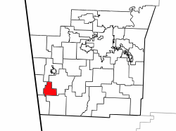 Location of Morrow Township in Washington County | |
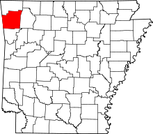 Location of Washington County in Arkansas | |
| Coordinates: 35°52′15″N 94°26′1″W / 35.87083°N 94.43361°WCoordinates: 35°52′15″N 94°26′1″W / 35.87083°N 94.43361°W | |
| Country |
|
| State |
|
| County | Washington |
| Area | |
| • Total | 11.3 sq mi (29 km2) |
| • Land | 11.3 sq mi (29 km2) |
| • Water | 0.0 sq mi (0 km2) 0% |
| Elevation | 1,142 ft (348 m) |
| Population (2000) | |
| • Total | 459 |
| • Density | 40/sq mi (20/km2) |
| Time zone | CST (UTC-6) |
| • Summer (DST) | CDT (UTC-5) |
| Area code(s) | 479 |
| GNIS feature ID | 69796 |
| U.S. Geological Survey Geographic Names Information System: Morrow Township, Washington County, Arkansas | |
Morrow Township is one of thirty-seven townships in Washington County, Arkansas, USA.[1] As of the 2000 census, its total population was 898.
Geography
According to the United States Census Bureau, Morrow Township covers an area of 11.3 square miles (29 km2); all land.[1]
Cities, towns, villages
Cemeteries
The township contains Bethesda Cemetery, Bethlehem Cemetery, Drake Cemetery, Edmiston Cemetery, and English Cemetery.
Major routes
See also
References
- United States Census Bureau 2008 TIGER/Line Shapefiles
- United States Board on Geographic Names (GNIS)
- United States National Atlas
- ↑ 1.0 1.1 "Township of Morrow, Washington County, Arkansas". U.S. Census Bureau. Retrieved 2011-09-16.
External links
 |
Starr Hill Township | Cane Hill Township | | |
| Dutch Mills Township | |
Center Township | ||
| ||||
| | ||||
| Vineyard Township | Boston Township |