Morlaàs
| Morlaàs | |
|---|---|
|
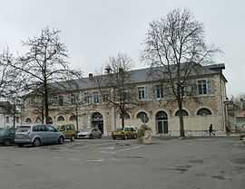
Morlaàs city hall | |
 Morlaàs | |
|
Location within Aquitaine region  Morlaàs | |
| Coordinates: 43°20′43″N 0°15′40″W / 43.3453°N 0.2611°WCoordinates: 43°20′43″N 0°15′40″W / 43.3453°N 0.2611°W | |
| Country | France |
| Region | Aquitaine |
| Department | Pyrénées-Atlantiques |
| Arrondissement | Pau |
| Canton |
Morlaàs (chef-lieu) |
| Intercommunality | Communauté de communes des Luy-Gabas-Souye et Lées |
| Government | |
| • Mayor (2008–2014) | Dino Forté |
| Area1 | 13.15 km2 (5.08 sq mi) |
| Population (2006)2 | 4,121 |
| • Density | 310/km2 (810/sq mi) |
| INSEE/Postal code | 64405 / 64160 |
| Elevation |
233–349 m (764–1,145 ft) (avg. 295 m or 968 ft) |
|
1 French Land Register data, which excludes lakes, ponds, glaciers > 1 km² (0.386 sq mi or 247 acres) and river estuaries. 2 Population without double counting: residents of multiple communes (e.g., students and military personnel) only counted once. | |
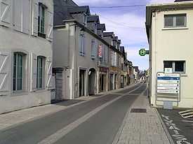
Main Street Morlaàs.
Morlaàs (Gascon Morlans) is a commune in the Pyrénées-Atlantiques department in south-western France.
It is the seat of a canton.
After the Roman city of Benearnum (today's Lescar) was razed by the Vikings in 841, Morlaàs became the capital of the ancient province of Béarn. It remained the capital until the 12th century, when Orthez took over.[1]
See also
References
| Wikimedia Commons has media related to Morlaàs. |