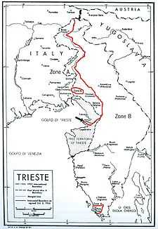
Morgan Line

The Morgan Line was the line of demarcation set up after World War II in the region known as Julian March which prior to the war belonged to the Kingdom of Italy. The Morgan Line was the border between two military administrations in the region: the Yugoslav on the east, and that of the Allied Military Government on the west. After 15 September 1947, the Allied Military Government was composed of both the British Element Trieste Forces (BETFOR) troops from the United Kingdom and the Trieste United States Troops (TRUST) from the United States.
Boundary
The Morgan Line established a temporary boundary between the Yugoslav and Allied administrations in the region of Julian March (Venezia Giulia), contended by Italy and the Socialist Federal Republic of Yugoslavia, and also to reduce the possibility of combat between Allied and Yugoslav forces in the area. The line was named after the British representative at the negotiations in Duino that resulted in the demarcation, Lieutenant General Sir William Duthie Morgan. Morgan, chief of staff to Field Marshal Sir Harold Alexander, Supreme Allied Commander in the Mediterranean, had been sent to Belgrade on May 7 to remind Yugoslav leader Josip Broz Tito that Yugoslav forces were in violation of a February 1945 written agreement between Tito and Alexander in occupying the territory. During the negotiations, Morgan drew up a line, then called the "Blue Line" and, when Allied troops of the British XIII Corps began moving forward to the blue line on May 22, Tito agreed in principle to the demarcation the next day, with the agreement signed in Duino on June 10, 1945.
Location
The line, approximately 70 miles in length, began on the coast just south of Trieste, curved 15 miles to the east and then northwest to Gorizia, Italy, then north along the Isonzo/Soča River through Kobarid to Rateče near the Italian-Austrian border. The demarcation divided the Julian March into two zones, "Zone A" under Allied military administration and "Zone B" under the administration of the Yugoslav People's Army.
Zone A
Zone A comprised the western portion of the region, which included the current Italian provinces of Trieste and Gorizia, a strip of territory between the current Slovene-Italian border and the Soča river, the Brda hills, the lower Vipava Valley (corresponding roughly to the current Slovene municipalities of Šempeter-Vrtojba, Renče-Vogrsko, Miren-Kostanjevica and most of the municipality of Nova Gorica, except the Banjšice Plateau), the western section of the Kras plateau (corresponding more or less to the current Slovene municipalities of Sežana and Komen), and the Istrian villages of Plavje, Spodnje Škofije, Jelarji and Hrvatini, now in Slovenia.
The Istrian coastal town of Pula (now in Croatia) was also under Allied administration, forming an enclave of Zone A within the territory of Zone B.
Zone B
The Yugoslav-administered Zone B extended to almost two-thirds of the region, including the city of Rijeka, most of the Istrian peninsula (with the exception of the town of Pula and the municipalities of Muggia and San Dorligo della Valle), the Cres-Lošinj archipelago, and the eastern portion of the Slovene Littoral. The village of Opatje Selo on the north-western edge of the Kras plateau formed a small enclave of Zone B within the territory of Zone A.
End of the line
The Morgan Line ceased to exist on 15 September 1947, when the Treaty of Paris came into effect. The Treaty established the border between Italy and Yugoslavia in the northern sections of the contended territory, while the Free Territory of Trieste was established in its southern part. Allied troops along the Morgan Line withdrew several miles to a parallel "French Line" (adopted at the recommendation of the French Foreign Minister), part of which ran along sections of the former Morgan Line.
The Free Territory was divided into Zone A and Zone B, and the border between the two ran along the Morgan line. In 1954, when the Free Territory was abolished and the villages of Plavje, Spodnje Škofije, Jelarji and Hrvatini annexed to Yugoslavia together with the entire zone B, the Morgan Line ceased to serve as an internationally recognized border.
Today, almost all of the former Morgan Line is completely within Slovenian territory. Only a very small part still serves as a border between Italy and Slovenia, dividing the Italian municipality of San Dorligo della Valle from the Slovenian municipality of Koper.
Source
- White's Political Dictionary, 1947